Maps of Postolin

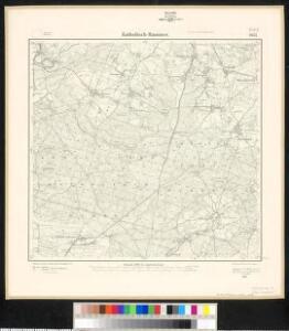
Meßtischblatt 2637 : Katholisch Hammer, 1937
1 : 250000 Katholisch Hammer. - Hrsg. 1887, bericht. 1928, einz. Nachtr. 1932, gedr. [19]37. - 1:25000. - [Berlin]: Reichsamt für Landesaufnahme, 1937. - 1 Kt.
Meßtischblatt 2637 : Katholisch- Hammer, 1902
1 : 250000 Katholisch- Hammer. - Aufn. 1885, hrsg. 1887, einz. Nachtr. 1895, gedr. [19]02. - 1:25000. - [Berlin]: Reichsamt für Landesaufnahme, 1902. - 1 Kt.
119. Breslau, uit: Topographische Uebersichtskarte des Deutschen Reiches / herausgegeben v. d. Kartogr. Abt. d. Königl. Preuß. Landesaufnahme
1 : 200000 titelvariant: Topogr. Übersichtskarte des Deutschen Reiches; Annotatie: Titel boven bladen ook: Topogr. Übersichtskarte des Deutschen Reiches; Annotatie geografische gegevens: Op elk blad twee maatstokken: 10 Kilometer = 5,5 cm; 1 geogr. Meile = 3,6 cm; Legenda onder op elk blad Königlich Preußische Landesaufnahme. Kartographische Abtheilung [S.l : Königlich Preußische Landesaufnahme, Kartographische Abtheilung]
La Haute et la Basse Silesie
1 : 3330000 Slezsko Lotter, Tobias Conrad Tobie Conrad Lotter
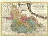
Das Fürstenthum Oels in Nieder-Schlesien nebst denen freyen Standes-Herrschaften Trachenberg, Militsch und Wartenberg
1 : 417770 Mollova mapová sbírka Schleuen, Johann David Schleuen, Johann David
Ducatus in Silesia Inferiore Olsnensis Novissima Delineatio
1 : 208000 Mollova mapová sbírka Schenk, Pieter Schenk, Peter II
Dvcatvs in Silesia Inferiore Olsnensis Novißima Delineato
1 : 216000 Mollova mapová sbírka Sinapius, Daniel Winckler, Christian
Das Fürstenthum Oels in Nieder-Schlesien nebst denen freyen Standes-Herrschafften Trachenberg, Militsch und Wartenberg
Oleśnica (Vratislav, Polsko) Wieland, Johann Wolfgang Schleuen, Johann David I.D. Schleuen
Principatvs Silesiae Oelsnensis :
1 : 154000 Mollova mapová sbírka Wieland, Johann Wolfgang Homann, Johann Baptista - dědici
DVCATVS | BRESLANVS | sive | WRATISLAVIENSIS
Amstelædami, Apud Joan. Blaeu
Principatvs Silesiae Oelsnensis in suos districtus Oels Bernstadt et Trebnitz divisi exactissima tabula geographica, exhibens insimul circumjacentes dynastias liberas Trachenberg et Militsch, cum statibus minoribus Freyhain Nevschlos, Goschvtz et Zvlavf
1 : 154000 Oleśnica (Vratislav, Polsko) Wieland, Johann Wolfgang Schubarth, Matthäus Haeretibus Homannianis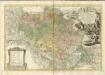

Breslau 77, uit: Special-Karte von Mittel-Europa / nach amtlichen Quellen bearbeitet von W. Liebenow
1 : 300000 titelvariant: W. Liebenow's Mittel-Europa; Annotatie: Titel boven de bladen: W. Liebenow's Mittel-Europa Johannes Wilhelm Liebenow 1822-1897 Frankfurt a. M. : Ludwig Ravenstein
Ducatus Breslanus sive Wratislaviensis. [Karte] Breslaw totius Silesiae Metropolis. [Nebenkarte], in: Novus atlas absolutissimus, Bd. 2, S. 264.
1 Karte aus Atlas Janssonius Offizin

Prov. Schlesien Reg. Bez
1 : 180000 Varšava-oblast (Polsko)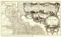
Basse Silesie Raduitte en deux Feuilles sur celle de 16 Faittes sur les lieux
1 : 408000 Mollova mapová sbírka Le Rouge, Georges-Louis Schubarth, Matthäus
Sect. 16: Posen, uit: Geologische Karte des Deutschen Reichs in 27 Blaettern / [von] Richard Lepsius ; Red. von C. Vogel
1 : 500000 Annotatie: Blad 18 ontbreekt; Een aantal bladen op linnen; Een aantal bladen gereviseerd 1913-1914; Annotatie geografische gegevens: Met schaalstokken o.a. in kilometers; Legenda Carl Vogel 1828-1897 Gotha : Justus Perthes
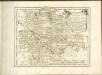
Silesia Inferior
1 : 870000 Mollova mapová sbírka Scultetus, Johannes Schenk, Peter I
Kolonie założone za panowania Fryderyka Wielkiego na Śląsku pruskim
Polen Schlesien Preußen Stadtgründung Friedrich II.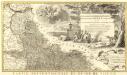
Novissimum Silesiae Theatrum
1 : 400800 Mollova mapová sbírka Condet, Johannes Covens, Johannes I
Parte inferiore del Ducato di Silesia
1 : 525000 Mollova mapová sbírka Cantelli, Giacomo De Rossi, Domenico
Posen
1 : 600000 Opitz, Carl Solbrig
Dvcatvs Silesiae Tabvla Geographica Prima, Inferiorem eivs partem, seu Novem Principatvs, quorum insignia hic adjecta sunt, secundum statum recentissimum complectens
1 : 575000 Mollova mapová sbírka Hase, Johann Matthias Homann, Johann Baptista - dědici
Monumenta Cartographica Bohemiae II.: Müllerova mapa

Provinz Posen
1 : 1200000 Provinz Posen
Dvcatvs Silesiae Tabvla Geographica Prima, Inferiorem eivs partem, seu novem principatvs, quorum insignia hic adjecta sunt, secundum statum recentissimum complectens =
1 : 575000 Mollova mapová sbírka Hase, Johann Matthias Homann, Johann Baptista - dědici