Maps of Großalmerode

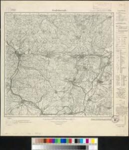
Meßtischblatt 2736 : Großalmerode, 1936
1 : 250000 Großalmerode. - Hrsg. 1909, einz. Nachtr. 1936. - 1:25000. - [Berlin]: Reichsamt für Landesaufnahme, 1936. - 1 Kt.
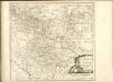
Les Environs de Cassel en Hesse et le Plan de la Battaille entre Sandershausen et Lutternberg le 10. Octobre 1758
Mollova mapová sbírka Back, Jakob Conrad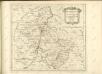

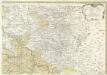
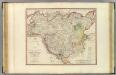
Le Landgraviat de Hesse-Cassel Meridional et Septentr: avec une Partie du Landgraviat de Hesse-Darmstat et de la Vetteravie avec autres dependences
1 : 200000 Mollova mapová sbírka Carlet, Louis-François Lotter, Tobias Conrad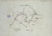
Verproviantirung von Göttingen im Januar 1761
Landgrafiatvs Hasso-Cassellanvs typo geographico quatuor Foliorum expressus Cura Homannianorum Heredum Norimb: 1761
1 : 160000 Mollova mapová sbírka Homann, Johann Baptist Homann, Johann Baptista - dědici
Landt Tafel des Eyßfeldts
1 : 180000 Mollova mapová sbírka Fluck, Johann Merian, Matthäus
Landgraviatus Hassiae Inferioris Comitatvs Waldeciae Eichsfeldiae Tabvla Geographica
1 : 140000 Mollova mapová sbírka Berger, Daniel
Tractvs Eichsfeldiae in suas Praefecturas divisae nec non Territorii Mvlhvsani Chorographia
1 : 160000 Mollova mapová sbírka Homann, Johann Baptist Homann, Johann Baptista - dědici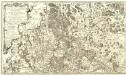
Carte Demi-Topo-Graphique De La Partie Septentrionale du Landgraviat de Hesse-Cassel
1 : 190000 Mollova mapová sbírka Carlet, Louis-François Beaurain, Jean de
112. Cassel, uit: Topographische Uebersichtskarte des Deutschen Reiches / herausgegeben v. d. Kartogr. Abt. d. Königl. Preuß. Landesaufnahme
1 : 200000 titelvariant: Topogr. Übersichtskarte des Deutschen Reiches; Annotatie: Titel boven bladen ook: Topogr. Übersichtskarte des Deutschen Reiches; Annotatie geografische gegevens: Op elk blad twee maatstokken: 10 Kilometer = 5,5 cm; 1 geogr. Meile = 3,6 cm; Legenda onder op elk blad Königlich Preußische Landesaufnahme. Kartographische Abtheilung [S.l : Königlich Preußische Landesaufnahme, Kartographische Abtheilung]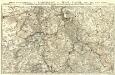
Partie Septentrionale du Landgraviat de Hesse-Cassel avec les Pays Voisins
1 : 130000 Mollova mapová sbírka Carlet, Louis-François Back, Jakob Conrad Broenner, Heinrich Ludwig II.
Cassel
1 : 300000 R. Mittelbach
Eveché de Paderborn
1 : 230000 Mollova mapová sbírka Le Rouge, Georges-Louis Baisiez Le Rouge, Georges-Louis
Recens et Accurata Designatio Episcopatus Paderbornensis in suas Dioecenses et Praefect. Exacte Distincti
1 : 230000 Mollova mapová sbírka Seutter, Matthäus Seutter, Matthäus
Le Theatre de Bellone :
Mollova mapová sbírka Schenk, Pieter Braakman, Adriaan
Vestrovaldia ad Septentrionem sita in IV. Mappis Geogr: Proposita cum adiac: Regionibus. cum Plurim: Privil:
1 : 210000 Mollova mapová sbírka Buna, Wilhelm C. Broenner, Heinrich Ludwig
Hassia Landgraviatus
1 : 350000 Mollova mapová sbírka Hondius, Henricus Janssonius, Johannes I
Uebersichts-Karte des Oberfürstenthums Hessen
Meister, G.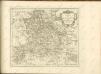
Holstein.
1 : 270000 Faden, William, 1750?-1836
Karte der Thüringer Eisenbahn
1 : 218000 Kunstanstalt von Mädel II

Hassia landtgrauiatus
1 Karte : Kupferdruck ; 33 x 40 cm Mercator; Hondius sumptibus Henrici Hondij
Hassia landtgrauiatus
1 Karte : Kupferdruck ; 33 x 40 cm Mercator s.n.
HASSIA | Landgraviatus.
[Amsterdam : Joan Blaeu]
Le Landgraviat de Hesse-Cassel, meridional et septentr. avec une partie de Landgraviat de Hesse-Darmstat et de la Vetteravie avec autres dependences
1 : 175000 par Mr. Carlet de la Roziere gravé par les soins et aux dépens du Tobie Conrad Lotter Augsbourg : Tobie Conrad Lotter
Hassia landtgrauiatus
1 : 410000 Mollova mapová sbírka Mercator, Gerhard Hondius, Henricus