Maps of Landkreis Kassel

Eveché de Paderborn
1 : 230000 Mollova mapová sbírka Le Rouge, Georges-Louis Baisiez Le Rouge, Georges-Louis
Recens et Accurata Designatio Episcopatus Paderbornensis in suas Dioecenses et Praefect. Exacte Distincti
1 : 230000 Mollova mapová sbírka Seutter, Matthäus Seutter, Matthäus
Carte de l'Evêché de Paderborn
1 : 180000 Mollova mapová sbírka Carlet, Louis-François Lotter, Tobias Conrad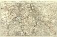
Partie Septentrionale du Landgraviat de Hesse-Cassel avec les Pays Voisins
1 : 130000 Mollova mapová sbírka Carlet, Louis-François Back, Jakob Conrad Broenner, Heinrich Ludwig II.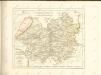

Paderbornensis Episcopatus Descriptio Nova [Karte], in: Novus Atlas, das ist, Weltbeschreibung, Bd. 1, S. 138.
1 Karte aus Atlas Blaeu, Joan Blaeu, Willem Janszoon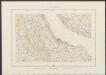
Paderbornensis Episcopatus, Descirptio Nova [Karte], in: Theatrum orbis terrarum, sive, Atlas novus, Bd. 1, S. 218.
1 Karte aus Atlas Blaeu, Joan Blaeu, Willem Janszoon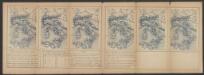
Paderbornensis Episcopatus Descriptio Nova [Karte], in: Le théâtre du monde, ou, Nouvel atlas contenant les chartes et descriptions de tous les païs de la terre, Bd. 1, S. 169.
1 Karte aus Atlas Blaeu, Willem Janszoon und Blaeu, Joan Blaeu, Willem Janszoon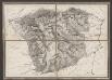
Episcopatus Paderbornensis descriptio nova [Karte], in: Gerardi Mercatoris et I. Hondii Newer Atlas, oder, Grosses Weltbuch, Bd. 1, S. 167.
1 Karte aus Atlas Mercator, Gerhard und Hondius, Jodocus Jansson, Jan
Episcopatus Paderbornensis descriptio nova [Karte], in: Novus atlas absolutissimus, Bd. 2, S. 124.
1 Karte aus Atlas Janssonius Offizin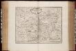
Episcopatus Paderbornensis descriptio nova / Iohanne Gigante Ludense ; [Henricus Hondius]
1 : 225000 Annotatie: Het eerst verschenen in: Novus Atlas ... Ersten Theils, Ander Stück. - Amstelodami : apud Ioannem Ianssonium, 1644; 1e staat: Amstelodami : Henricus Hondius, [1630]; Origineel is Blad 75 in atlas factice Gigas, Joannes (1580-1650); Hondius, Henricus Amstelodami : Joannes Janssonius excudit
Paderbornensis episcopatus descripto nova
1 : 222000 Paderborn-oblast (Německo) Gigas, Johann Michael Blaeu, Willem Janszoon Guilielmus Blaeuw
PADERBORNENSIS | Episcopatus | DESCRIPTIO NOVA
Ioanne Gigante Ludense D. Med. et Math. auth. Amstelodami Judocus Hondius excudit
Episcopatvs Paderbornensis descriptio nova
1 : 230000 Mollova mapová sbírka Gigas, Johann Michael Schenk, Peter I
Paderbornensis Episcopatus Descriptio Nova
1 : 220000 Mollova mapová sbírka Gigas, Johann Michael Blaeu, Willem Jansz.
Paderbornensis Episcopatus Descriptio Nova
1 : 220000 Mollova mapová sbírka Gigas, Johann Michael
Paderbornensis Episcopatus Descriptio Nova
1 : 220000 Mollova mapová sbírka Gigas, Johann Michael
Episcopatvs Paderborn nec non Abbatiae Corvei Territorium seculare
1 : 190000 Mollova mapová sbírka Gigas, Johann Michael Homann, Johann Baptista - dědici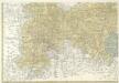
Landgrafiatvs Hasso-Cassellanvs typo geographico quatuor Foliorum expressus Cura Homannianorum Heredum Norimb: 1761
1 : 160000 Mollova mapová sbírka Homann, Johann Baptist Homann, Johann Baptista - dědici
Le Landgraviat de Hesse-Cassel Meridional et Septentr: avec une Partie du Landgraviat de Hesse-Darmstat et de la Vetteravie avec autres dependences
1 : 200000 Mollova mapová sbírka Carlet, Louis-François Lotter, Tobias Conrad
98. Detmold, uit: Topographische Uebersichtskarte des Deutschen Reiches / herausgegeben v. d. Kartogr. Abt. d. Königl. Preuß. Landesaufnahme
1 : 200000 titelvariant: Topogr. Übersichtskarte des Deutschen Reiches; Annotatie: Titel boven bladen ook: Topogr. Übersichtskarte des Deutschen Reiches; Annotatie geografische gegevens: Op elk blad twee maatstokken: 10 Kilometer = 5,5 cm; 1 geogr. Meile = 3,6 cm; Legenda onder op elk blad Königlich Preußische Landesaufnahme. Kartographische Abtheilung [S.l : Königlich Preußische Landesaufnahme, Kartographische Abtheilung]
Landgraviatus Hassiae Inferioris Comitatvs Waldeciae Eichsfeldiae Tabvla Geographica
1 : 140000 Mollova mapová sbírka Berger, Daniel
Waldeccensis Comitatus Descriptio Accuratissima. [Karte], in: Theatrum orbis terrarum, S. 145.
1 Karte aus Atlas Ortelius, Abraham
Cassel-Göttingen 72, uit: Special-Karte von Mittel-Europa / nach amtlichen Quellen bearbeitet von W. Liebenow
1 : 300000 titelvariant: W. Liebenow's Mittel-Europa; Annotatie: Titel boven de bladen: W. Liebenow's Mittel-Europa Johannes Wilhelm Liebenow 1822-1897 Frankfurt a. M. : Ludwig Ravenstein
Cassel 72, uit: [W. Liebenow's Special-Karte von Mittel-Europa]
1 : 300000 titelvariant: W. Liebenow's Mittel-Europa; Annotatie: Titel boven de bladen: W. Liebenow's Mittel-Europa Johannes Wilhelm Liebenow 1822-1897 Hannover : Hermann Oppermann
Le Landgraviat de Hesse-Cassel Meridional et Septentr: avec une Partie du Landgraviat de Hesse-Darmstat et de la Vetteravie avec autres dependences
1 : 200000 Mollova mapová sbírka Carlet, Louis-François Lotter, Tobias Conrad

WALDECK | COMITATVS
Amsterdami | Apud Guiljelmum Blaeu
Waldeck Comitatus. [Karte], in: Le théâtre du monde, ou, Nouvel atlas contenant les chartes et descriptions de tous les païs de la terre, Bd. 1, S. 175.
1 Karte aus Atlas Blaeu, Willem Janszoon und Blaeu, Joan Blaeu, Willem Janszoon


