Maps of Unstruttal

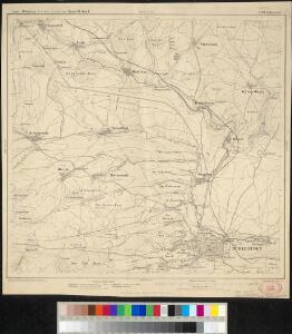
Meßtischblatt 4728 : Mühlhausen (In Thüringen), 1936
1 : 250000 Mühlhausen (In Thüringen). - Hrsg. 1909, einz. Nachtr. 1936. - 1:25000. - [Berlin]: Reichsamt für Landesaufnahme, 1936. - 1 Kt.
Meßtischblatt 2740 : Mühlhausen (In Thüringen), 1868
1 : 250000 Mühlhausen (In Thüringen). - Aufn. 1854. - 1:25000. - [Berlin]: Reichsamt für Landesaufnahme, 1868. - 1 Kt.
Les Environs de Cassel en Hesse et le Plan de la Battaille entre Sandershausen et Lutternberg le 10. Octobre 1758
Mollova mapová sbírka Back, Jakob Conrad
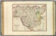
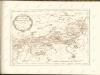
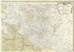
Landgraviatus Hassiae Inferioris Comitatvs Waldeciae Eichsfeldiae Tabvla Geographica
1 : 140000 Mollova mapová sbírka Berger, Daniel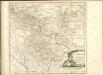

113. Sondershausen, uit: Topographische Uebersichtskarte des Deutschen Reiches / herausgegeben v. d. Kartogr. Abt. d. Königl. Preuß. Landesaufnahme
1 : 200000 titelvariant: Topogr. Übersichtskarte des Deutschen Reiches; Annotatie: Titel boven bladen ook: Topogr. Übersichtskarte des Deutschen Reiches; Annotatie geografische gegevens: Op elk blad twee maatstokken: 10 Kilometer = 5,5 cm; 1 geogr. Meile = 3,6 cm; Legenda onder op elk blad Königlich Preußische Landesaufnahme. Kartographische Abtheilung [S.l : Königlich Preußische Landesaufnahme, Kartographische Abtheilung]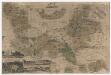
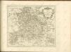
Karte des Fürstentums Schwarzburg-Sondershausen in Thüringen
Mit drei Zeichnungen eines Lust- und Jagdschlosses, der Residenzstadt Sondershausen und dem Amts- und Marktflecken Ebeleben. Mit Erklärung der verwendeten Zeichen. Meisner, Johann Wilhelm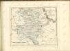
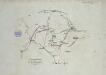
Verproviantirung von Göttingen im Januar 1761
Landgrafiatvs Hasso-Cassellanvs typo geographico quatuor Foliorum expressus Cura Homannianorum Heredum Norimb: 1761
1 : 160000 Mollova mapová sbírka Homann, Johann Baptist Homann, Johann Baptista - dědici
Landt Tafel des Eyßfeldts
1 : 180000 Mollova mapová sbírka Fluck, Johann Merian, Matthäus
Tractvs Eichsfeldiae in suas Praefecturas divisae nec non Territorii Mvlhvsani Chorographia
1 : 160000 Mollova mapová sbírka Homann, Johann Baptist Homann, Johann Baptista - dědici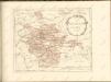

LandtTafel des Eyszfeldts
1 : 180000 Karte des Eichsfelds Flucken, Johann ; Merian Mattäus Merianische Erben
Abriß der am fünften des Wintermondes im 1757sten Jahre bey Roßbach im Merseburgischen zwischen der Römisch-Kaiserlichen Reichs-Armee, unter des Prinzen von Hildburgshausen Durchlaucht Commando, als Reichsfeldmarschall, nebst der damit vereinigten Königlichen französischen Armee, unter des Prinzen von Soubise Durchlaucht Commando, und zwischen dem Königlichen preußischen von dem Könige selbst angeführten Kriegsheere, gehaltenen Schlacht
1 : 300000 Mollova mapová sbírka Trattner, Johann Thomas Trattner, Johann Thomas von
Tvringiae noviss. descript
1 Karte : Kupferdruck ; 28 x 20 cm Mellinger; Ortelius s.n.
Tvringiae noviss. descript
1 Karte : Kupferdruck ; 28 x 20 cm Mellinger; Ortelius s.n.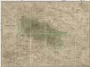
Special Charte von dem Harz-Gebirge und den umliegenden Ländern
Harz-oblast (Německo) von dem Geographischen Institute
Herzogtum Sachsen-Coburg und Gotha 1830 Verwaltungsstruktur
Sachsen-Coburg-Gotha Verwaltung Kunz, Andreas ; Moeschl, Joachim Robert
Herzogtum Sachsen-Coburg und Gotha 1826 Verwaltungsstruktur
Sachsen-Coburg-Gotha Verwaltung Kunz, Andreas ; Moeschl, Joachim Robert
Herzogtum Sachsen-Coburg und Gotha 1834 Verwaltungsstruktur
Sachsen-Coburg-Gotha Verwaltung Kunz, Andreas ; Moeschl, Joachim Robert

Geographische Charte
1 : 300000 Mollova mapová sbírka Zollmann, Friedrich

Thvringia Landgraviatvs
1 : 420000 Mollova mapová sbírka Merian, Matthaeus Merian, Matthäus
Thvringia
1 Karte : Kupferdruck ; 33 x 40 cm Mercator; Hondius sumptibus Henrici Hondÿ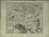
Thvringia
1 Karte : Kupferdruck ; 33 x 40 cm Mercator s.n.