Maps of Waldkappel

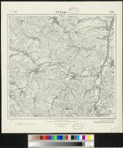
Meßtischblatt 2798 : Waldkappel, 1927
1 : 250000 Waldkappel. - Hrsg. 1909, Nachtr. 1927. - 1:25000. - [Berlin]: Reichsamt für Landesaufnahme, 1927. - 1 Kt.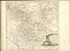

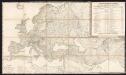
Tractvs Eichsfeldiae in suas Praefecturas divisae nec non Territorii Mvlhvsani Chorographia
1 : 160000 Mollova mapová sbírka Homann, Johann Baptist Homann, Johann Baptista - dědici
Eisenach 86, uit: [W. Liebenow's Special-Karte von Mittel-Europa]
1 : 300000 titelvariant: W. Liebenow's Mittel-Europa; Annotatie: Titel boven de bladen: W. Liebenow's Mittel-Europa Johannes Wilhelm Liebenow 1822-1897 Hannover : Hermann Oppermann
112. Cassel, uit: Topographische Uebersichtskarte des Deutschen Reiches / herausgegeben v. d. Kartogr. Abt. d. Königl. Preuß. Landesaufnahme
1 : 200000 titelvariant: Topogr. Übersichtskarte des Deutschen Reiches; Annotatie: Titel boven bladen ook: Topogr. Übersichtskarte des Deutschen Reiches; Annotatie geografische gegevens: Op elk blad twee maatstokken: 10 Kilometer = 5,5 cm; 1 geogr. Meile = 3,6 cm; Legenda onder op elk blad Königlich Preußische Landesaufnahme. Kartographische Abtheilung [S.l : Königlich Preußische Landesaufnahme, Kartographische Abtheilung]
Eisenach 86, uit: Special-Karte von Mittel-Europa / nach amtlichen Quellen bearbeitet von W. Liebenow
1 : 300000 titelvariant: W. Liebenow's Mittel-Europa; Annotatie: Titel boven de bladen: W. Liebenow's Mittel-Europa Johannes Wilhelm Liebenow 1822-1897 Frankfurt a. M. : Ludwig Ravenstein
Cassel
1 : 300000 R. Mittelbach
Herzogtum Sachsen-Coburg und Gotha 1830 Verwaltungsstruktur
Sachsen-Coburg-Gotha Verwaltung Kunz, Andreas ; Moeschl, Joachim Robert
Herzogtum Sachsen-Coburg und Gotha 1826 Verwaltungsstruktur
Sachsen-Coburg-Gotha Verwaltung Kunz, Andreas ; Moeschl, Joachim Robert
Herzogtum Sachsen-Coburg und Gotha 1834 Verwaltungsstruktur
Sachsen-Coburg-Gotha Verwaltung Kunz, Andreas ; Moeschl, Joachim Robert
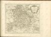
Principatus Isenacensis cum adjacentibus vicinorum statuum ditionibus exhibitus
1 : 190000 Durynsko (Německo) Homann, Johann Baptist J. B. Homann
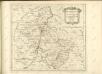
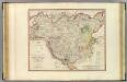
Hassia Landgraviatus
1 : 350000 Mollova mapová sbírka Hondius, Henricus Janssonius, Johannes I
Holstein.
1 : 270000 Faden, William, 1750?-1836
Turingiae Noviss. Descript. [Karte], in: Theatrum orbis terrarum, S. 137.
1 Karte aus Atlas Ortelius, Abraham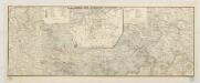
Karte der Thüringer Eisenbahn
1 : 218000 Kunstanstalt von Mädel II
Illustrissimo principi Ioanni Georgio duci Saxoniae hanc Thuringiae lantgraviatus tabulam omni animi devotione
1 : 344000 Durynsko (Německo) Schenk, Pieter Petrus Schenk

Hassia landtgrauiatus
1 Karte : Kupferdruck ; 33 x 40 cm Mercator; Hondius sumptibus Henrici Hondij
Hassia landtgrauiatus
1 Karte : Kupferdruck ; 33 x 40 cm Mercator s.n.
HASSIA | Landgraviatus.
[Amsterdam : Joan Blaeu]

Le Landgraviat de Hesse-Cassel, meridional et septentr. avec une partie de Landgraviat de Hesse-Darmstat et de la Vetteravie avec autres dependences
1 : 175000 par Mr. Carlet de la Roziere gravé par les soins et aux dépens du Tobie Conrad Lotter Augsbourg : Tobie Conrad Lotter
Thuringia Landgraviatus [Karte], in: Theatrum orbis terrarum, sive, Atlas novus, Bd. 1, S. 248.
1 Karte aus Atlas Blaeu, Joan Blaeu, Willem Janszoon
Hassia landtgrauiatus
1 : 410000 Mollova mapová sbírka Mercator, Gerhard Hondius, Henricus
Landgrafschafft Thüringen mit ihren abgetheilten Provintzen im Ober Sächßischen Creisse
1 : 1000000 Mollova mapová sbírka Weigel, Christoph Weigel, Christoph I.