Maps of Pisarzowice

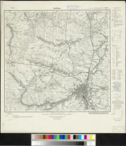
Meßtischblatt 2817 : Lauban, 1929
1 : 250000 Lauban. - Hrsg. 1887, einz. Nachtr. 1929. - 1:25000. - [Berlin]: Reichsamt für Landesaufnahme, 1929. - 1 Kt.
Laubanum

Tschernhausen und Preuss. Cörlitz [sic]
1 : 75000 Görlitz-oblast (Německo) K. u. k. Militärgeographisches Institut
III. vojenské mapování 3554
1 : 75000
[Kartenblatt]
1 : 25000 Dolní Oldřiš (Bulovka, Liberec, Česko) Reichsamt für Landesaufnahme
Tschernhausen und Preuss. Corlitz.
from Spezialkarte der osterreichisch-ungarischen Monarchie.
Mappa vicariatus Fridlandensis
Frýdlant-oblast (Česko) Kreibich, František Jakub Jindřich
117. Görlitz, uit: Topographische Uebersichtskarte des Deutschen Reiches / herausgegeben v. d. Kartogr. Abt. d. Königl. Preuß. Landesaufnahme
1 : 200000 titelvariant: Topogr. Übersichtskarte des Deutschen Reiches; Annotatie: Titel boven bladen ook: Topogr. Übersichtskarte des Deutschen Reiches; Annotatie geografische gegevens: Op elk blad twee maatstokken: 10 Kilometer = 5,5 cm; 1 geogr. Meile = 3,6 cm; Legenda onder op elk blad Königlich Preußische Landesaufnahme. Kartographische Abtheilung [S.l : Königlich Preußische Landesaufnahme, Kartographische Abtheilung]
Wegekarte vom Riesen- und Iser-Gebirge
1 : 150000 Jizerské hory-oblast (Česko a Polsko) Straube, Julius Geograph. Inst. u. Landkarten-Verlag v. Jul. Straube
Geographische Verzeichnung des GOERLIZER CREISES mit dem QVEISS-CREISE welches zusammen ist der Ostliche Theil von dem Marggrafthum OBER LAVSITZ
1 : 180000 Görlitz (Německo) vom Homaennischen Erben
Geographische Verzeichnung des Goerlizer Creises mit dem Qveiss-Creise
1 : 176200 Görlitz (Německo) Homaennischen Erben
Geographische Verzeichnung des Goerlizer Creises mit dem Qveiss-Creise welches zusammen ist der Ostliche Theil von dem Marggrafthum Ober Lavsiz
1 : 180000 Mollova mapová sbírka Homann, Johann Baptist Homann, Johann Baptista - dědici
Generální mapa Protektorátu Čechy a Morava
Princip. Silesiae Iavoriensis in IV. Circulos, Iaver, Hirschberg, Lemberg und Bvmtzlav divisi ac.
1 : 150000 Mollova mapová sbírka Wieland, Johann Wolfgang Homann, Johann Baptista - dědici
Principatvs Silesiae Iavoricensis in 4 circulos, Iaver, Hirschberg, Lemberg und Bvntzlav divisi
1 : 150000 Bolesławiec (Polsko) Wieland, Johann Wolfgang Schubarth, Matthäus Homannianos Heredes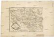
Die Markgrafschaft Oberlausitz in ihre Kreise eingetheilt.
1 : 363000 Horní Lužice (Německo) Hübner, Johann Homann, Johann Baptist
DVCATVS | SILESIÆ | IAVRANI | DELINEATIO
Auctore Friderico Kuhnovio | Bolcol. Siles. Exc. I. Blaeuw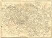
La Haute Lusace
1 : 180000 Mollova mapová sbírka Le Rouge, Georges-Louis Le Rouge, Georges-Louis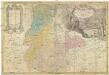
PRINCIP. SILESIAE IAVORIENSIS in IV. CIRCULOS, IAVER, HIRSCHBERG, LEMBERG und BVNTZLAV DIVISI
1 : 150000 Jelení Hora-oblast (Polsko) Wieland, Johann Wolfgang Schubarth, Matthaeus ab Hered. Homannianis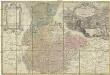
Princip. Silesiae Iavoriensis in IV. circulos, Iaver, Hirschberg, Lemberg und Bvntzlau divisi ac a I. W. Wieland
1 : 150000 Jawor (Polsko) Schubart, Mathaeum Hered. Homannianis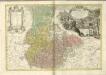
Principatvs Silesiae Schwidnicensis
1 : 128000 Svídnice-oblast (Polsko) Wieland, Johann Wolfgang Schubarth, Matthäus Hered. Homannianis
Ober Lausitz entworffen, und in Kupffer gestochen
1 : 230000 Mollova mapová sbírka Schreiber, Johann Georg Schreiber, Johann Georg
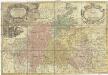
Lusatia Superior
1 : 260000 Mollova mapová sbírka Scultetus, Bartholomaeus Janssonius Van Waesberge, Johannes II
Lusatia Superior
1 : 260000 Mollova mapová sbírka Scultetus, Bartholomaeus Schenk, Peter I
Lusatia Superior
1 : 260000 Mollova mapová sbírka Funck, David Funck, David
Marchionatus Lusatiae superioris felicissimo Poloniae regis, electoris Saxoniae, sceptro florens, dynastiis et praefecturis suis distributus nova accuratione
Horní Lužice (Německo) Seutter, Matthäus Lotter, Tobias Conrad Matth. Seutteri
Lusatia Superior
1 : 320000 Mollova mapová sbírka Weigel, Christoph Weigel, Christoph I.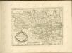

Lusatiae superioris tabula chorographica
1 : 215000 Horní Lužice (Německo) Schreiber, Johann Georg excusa studio Homannianorum Heredum