Maps of gmina Gryfów Śląski

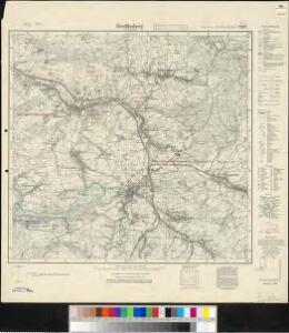
Meßtischblatt 2882 : Greiffenberg in Niederschlesien, 1933
1 : 250000 Greiffenberg in Niederschlesien. - Hrsg. 1887, bericht. 1929, gedr. [19]33. - 1:25000. - [Berlin]: Reichsamt für Landesaufnahme, 1933. - 1 Kt.

150 Hirschberg, uit: Topographische Special-Karte von Deutschland (von Central-Europa) / begründet von D.G. Reymann ; [entworfen und gezeichn. von Heinrich Berghaus... [et al.]]
1 : 200000 Annotatie: Lit.: Daniel Gottlob Reymann und die "Topographische Special-Karte von Deutschland" / von Wolfgang Scharfe, in: Kartographische Nachrichten, 39 (1989), Heft I, p. 1-10; Handgeschreven titel: Reymann's Deutschland : 24 Sectionen: Jena, Penig, Dresden, Zittau, Hirschberg, Breslau, Brieg, Andernach, Coblenz, Giessen, Fulda, Schleusingen, Plauen, Zwickau, Teplitz, Jung Bunzlau, Hohenelbe, Glatz, Neisse, Simmern, Prag, Luxemburg, Birkenfeld; Aanwezig: 23 bladen Reymann, Daniel Gottlob; Berghaus, Heinrich [Berlin : 2. Departement des Kriegsministeriums, Bureau für Plan- und Kartenzeichnung]
Müllerova mapa Čech
1 : 132000
118. Liegnitz, uit: Topographische Uebersichtskarte des Deutschen Reiches / herausgegeben v. d. Kartogr. Abt. d. Königl. Preuß. Landesaufnahme
1 : 200000 titelvariant: Topogr. Übersichtskarte des Deutschen Reiches; Annotatie: Titel boven bladen ook: Topogr. Übersichtskarte des Deutschen Reiches; Annotatie geografische gegevens: Op elk blad twee maatstokken: 10 Kilometer = 5,5 cm; 1 geogr. Meile = 3,6 cm; Legenda onder op elk blad Königlich Preußische Landesaufnahme. Kartographische Abtheilung [S.l : Königlich Preußische Landesaufnahme, Kartographische Abtheilung]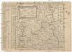
Mappa vicariatus Fridlandensis
Frýdlant-oblast (Česko) Kreibich, František Jakub Jindřich

Karte des Riesengebirges
1 : 200000 Krkonoše (Česko a Polsko : pohoří : oblast) Reymann, Gottlob Daniel C. Flemming
Wegekarte vom Riesen- und Iser-Gebirge
1 : 150000 Jizerské hory-oblast (Česko a Polsko) Straube, Julius Geograph. Inst. u. Landkarten-Verlag v. Jul. Straube
Spezial-Karte vom Riesen-Gebirge.
1 : 200000 Berghaus, Heinrich
[Spezial-Karte vom Riesen-Gebirge]
Erster Band, enthaltend in vier Abtheilungen die Erscheinungen der anorganischen Natur: 1. Meteorologie und Klimatographie. 2. Hydrologie und Hydrographie. 3. Geologie. 4. Tellurischer Magnetismus Humboldt, Alexander von Verlag von Justus Perthes
Generální mapa Protektorátu Čechy a Morava

Neubertova generální automapa Republiky československé
1 : 200000 Liberec (Česko : oblast) Soukup, Jan V. Neubert a synové
Princip. Silesiae Iavoriensis in IV. Circulos, Iaver, Hirschberg, Lemberg und Bvmtzlav divisi ac.
1 : 150000 Mollova mapová sbírka Wieland, Johann Wolfgang Homann, Johann Baptista - dědici
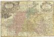
Principatvs Silesiae Iavoricensis in 4 circulos, Iaver, Hirschberg, Lemberg und Bvntzlav divisi
1 : 150000 Bolesławiec (Polsko) Wieland, Johann Wolfgang Schubarth, Matthäus Homannianos Heredes
DVCATVS | SILESIÆ | IAVRANI | DELINEATIO
Auctore Friderico Kuhnovio | Bolcol. Siles. Exc. I. Blaeuw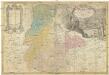
PRINCIP. SILESIAE IAVORIENSIS in IV. CIRCULOS, IAVER, HIRSCHBERG, LEMBERG und BVNTZLAV DIVISI
1 : 150000 Jelení Hora-oblast (Polsko) Wieland, Johann Wolfgang Schubarth, Matthaeus ab Hered. Homannianis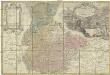
Princip. Silesiae Iavoriensis in IV. circulos, Iaver, Hirschberg, Lemberg und Bvntzlau divisi ac a I. W. Wieland
1 : 150000 Jawor (Polsko) Schubart, Mathaeum Hered. Homannianis
Hirschberg 90, uit: Special-Karte von Mittel-Europa / nach amtlichen Quellen bearbeitet von W. Liebenow
1 : 300000 titelvariant: W. Liebenow's Mittel-Europa; Annotatie: Titel boven de bladen: W. Liebenow's Mittel-Europa Johannes Wilhelm Liebenow 1822-1897 Frankfurt a. M. : Ludwig Ravenstein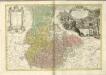
Principatvs Silesiae Schwidnicensis
1 : 128000 Svídnice-oblast (Polsko) Wieland, Johann Wolfgang Schubarth, Matthäus Hered. Homannianis
Lusatia Superior
1 : 320000 Mollova mapová sbírka Weigel, Christoph Weigel, Christoph I.
LVSATIA | SVPERIOR
Authore | Barthol. Sculteto Gorlitio. [Amsterdam : Joan Blaeu]
Das Land an der Flüssen Neisse, Queis, Bober, Katzbach und der wüthenden Neisse
1 : 440000 Kaczawa (Polsko)

Lusatiae superioris tabula chorographica
1 : 241000 Horní Lužice (Německo) Schreiber, Johann Georg excusa studio Homannianorum Heredum
Lusatiae superioris tabula chorographica
1 : 241000 Horní Lužice (Německo) Schreiber, Johann Georg excusa studio Homannianorum Heredum
Lusatiae superioris tabula chorographica
1 : 241000 Horní Lužice (Německo) Schreiber, Johann Georg excusa studio Homannianorum Heredum
Lusatia Superior. [Karte], in: Novus Atlas, das ist, Weltbeschreibung, Bd. 1, S. 168.
1 Karte aus Atlas Blaeu, Joan Blaeu, Willem Janszoon