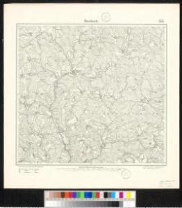
Maps of Morsbach

Meßtischblatt 2976 : Morsbach, 1896
1 : 250000 Morsbach. - Aufn. 1894. - 1:25000. - [Berlin]: Kgl. Preuss. Landesaufnahme, 1896. - 1 Kt.
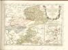
Delineatio Geographica generalis comprehendens VI. Foliis Singulos Principatvs Comitatvs Ditiones Dynastias omnes quotquot Imperio Serenissimi Principis Landgrafii Hasso-Darmstadiensis subsunt :
1 : 180000 Mollova mapová sbírka Bronner, Christian Maximilian Homann, Johann Baptista - dědici
Le Flambeau de la Guerre Allumee au Rhin
Mollova mapová sbírka Delisle, Guillaume Schenk, Peter II
124. Siegen, uit: Topographische Uebersichtskarte des Deutschen Reiches / herausgegeben v. d. Kartogr. Abt. d. Königl. Preuß. Landesaufnahme
1 : 200000 titelvariant: Topogr. Übersichtskarte des Deutschen Reiches; Annotatie: Titel boven bladen ook: Topogr. Übersichtskarte des Deutschen Reiches; Annotatie geografische gegevens: Op elk blad twee maatstokken: 10 Kilometer = 5,5 cm; 1 geogr. Meile = 3,6 cm; Legenda onder op elk blad Königlich Preußische Landesaufnahme. Kartographische Abtheilung [S.l : Königlich Preußische Landesaufnahme, Kartographische Abtheilung]
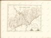
Neue Topographische Carte Der Sieg und Agger von ihrem Ursprunge bis zu ihrem Einflus in den Rhein mit Bemerkung der in dieser Gegend vorgefallenen Kriegsbegebenheiten von 1795 und 1796
Brand, Peter; Schalck, Anna Maria; Coentgen, Georg Joseph Brand
Wetzlar 85, uit: [W. Liebenow's Special-Karte von Mittel-Europa]
1 : 300000 titelvariant: W. Liebenow's Mittel-Europa; Annotatie: Titel boven de bladen: W. Liebenow's Mittel-Europa Johannes Wilhelm Liebenow 1822-1897 Hannover : Hermann Oppermann
Wetzlar 85, uit: Special-Karte von Mittel-Europa / nach amtlichen Quellen bearbeitet von W. Liebenow
1 : 300000 titelvariant: W. Liebenow's Mittel-Europa; Annotatie: Titel boven de bladen: W. Liebenow's Mittel-Europa Johannes Wilhelm Liebenow 1822-1897 Frankfurt a. M. : Ludwig Ravenstein
Le Duché de Berg, le Comté de Homberg, les Seugneries de Hardenberg, et de Wildenborg
1 : 230000 Mollova mapová sbírka Sanson, Guillaume Covens, Johannes I
Le Duché de Berg, le Comté de Homberg, les Seugneries de Hardenberg, et de Wildenborg
1 : 230000 Mollova mapová sbírka Sanson, Guillaume Jaillot, Alexis Hubert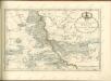

Das Herzogthum Nassau
1 : 200000 Wimmer, Friedrich Scholz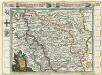
Das Herzogthum Berg hat in die Länge 15 teutsche Meilen und in die dreite 7 =
1 : 690000 Mollova mapová sbírka Baeck, Elias Bäck, Elias
Nassovia Comitatvs
1 : 1300000 Mollova mapová sbírka Hondius, Henricus Hondius, Henricus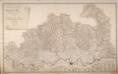
Topographisch-Militairische Karte Des Herzogthums Berg
Wiebeking, Carl Friedrich von; Bechstatt, I. C.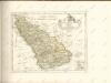

Le Duché De Berg, Le Comté De Homberg, Les Seigneuries De Hardenberg, Et De Wildenborg [Karte], in: Atlas nouveau, contenant toutes les parties du monde [...], Bd. 1, S. 222.
1 Karte aus Atlas Sanson, Nicolas Jaillot, Alexis Hubert und Mortier, Pieter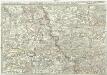
Exactissima totius Vederoviae late sumtae tabula, cujus pars prima est Vederovia stricte sic dicta versus meridiem
1 : 148000 Jülich (Německo) Buna, Wilhelm C.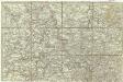
[Exactissima totius Vederoviae late sumtae tabula, cujus pars prima est Vederovia stricte sic dicta versus meridiem]
1 : 148000 Jülich (Německo) Buna, Wilhelm C.
Das Herzogthum Nassau
1 : 438000 Weimar : Verlag des Geographischen Instituts
[21] Sec. Siegen, uit: Geologische Karte der Rheinprovinz und der Provinz Westphalen / ausgeführt durch H. von Dechen
1 : 80000 titelvariant: Dechen's geologische Karte vom Rheinland und Westphalen; Annotatie: Titel op bladoverzicht; Incompleet Heinrich von Dechen Berlin : Schropp
Principatus Nassaviae, divisus in speciales Comitatus, Nassaviam, Hadamariam, Beilstenium, Veilburgum, Dietziam, Usingam, Id Stanium, Dilemburgum et Sigenam ostenduntur
1 : 200000 Mollova mapová sbírka Valk, Gerhard Valck, Gerard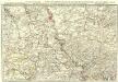
Exactissima totius Vederoviae laté sumtae Tabula
1 : 210000 Mollova mapová sbírka Buna, Wilhelm C. Broenner, Heinrich Ludwig

Herzogthum Nassau, Landgrafschaft Hessen Homburg und die Freie Stadt Frankfurt
Grosser Hand-Atlas über alle Theile der Erde in 170 Karten Meyer, J. Verlag des Bibliographischen Instituts
Herzogthum Nassau
1 : 538200 Nasavsko Hoeckner, Carl aus der Schweinfurten Geographischen Gravirsanstalt des Bibliographischen Instituts
NASSOVIA | Comitatus
Salomon Rogiers sculpsit [Amsterdam : Joan Blaeu]
[Kaart], uit: Kleines Relief-Panorama des Rheines
titelvariant: Kleines farbiges Relief-Panorama des Rheines; Annotatie: Titel op omslag: Kleines farbiges Relief-Panorama des Rheines; Met ill. van bezienswaardigheden aan weerszijden van de kaart Köln am Rhein : Hoursch & Bechstedt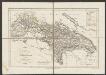
Nassovia Comitatus [Karte], in: Gerardi Mercatoris et I. Hondii Newer Atlas, oder, Grosses Weltbuch, Bd. 1, S. 200.
1 Karte aus Atlas Mercator, Gerhard und Hondius, Jodocus Jansson, Jan