Maps of Dierdorf

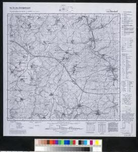
Meßtischblatt 5411 : Dierdorf, 1943
1 : 250000 Dierdorf. - Aufn. 1899, hrsg. 1901, letzte Nachtr. 1940. - 1:25000. - [Berlin]: Reichsamt für Landesaufnahme, 1943. - 1 Kt.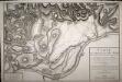
Carte de la Bataille de Neu Wied entre une Partie de l'Armée Française de Sambre et Meuse Commandée parl le Général en chef Hoch et le Corps Autrichiens commandé par le Général Krai

[25] Sect. Coblenz, uit: Geologische Karte der Rheinprovinz und der Provinz Westphalen / ausgeführt durch H. von Dechen
1 : 80000 titelvariant: Dechen's geologische Karte vom Rheinland und Westphalen; Annotatie: Titel op bladoverzicht; Incompleet Heinrich von Dechen Berlin : Schropp
Le Flambeau de la Guerre Allumee au Rhin
Mollova mapová sbírka Delisle, Guillaume Schenk, Peter II
124. Siegen, uit: Topographische Uebersichtskarte des Deutschen Reiches / herausgegeben v. d. Kartogr. Abt. d. Königl. Preuß. Landesaufnahme
1 : 200000 titelvariant: Topogr. Übersichtskarte des Deutschen Reiches; Annotatie: Titel boven bladen ook: Topogr. Übersichtskarte des Deutschen Reiches; Annotatie geografische gegevens: Op elk blad twee maatstokken: 10 Kilometer = 5,5 cm; 1 geogr. Meile = 3,6 cm; Legenda onder op elk blad Königlich Preußische Landesaufnahme. Kartographische Abtheilung [S.l : Königlich Preußische Landesaufnahme, Kartographische Abtheilung]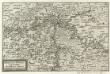
Mosella et Rheni Confluxus
Mollova mapová sbírka Person, Nikolaus Person, Nicolas
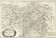
Nassoviae Principatus et ad cum spectantes Ditiones
1 : 180000 Mollova mapová sbírka Seutter, Matthäus Seutter, Matthäus
Partie Orientale du Temporel, de l'Archevesché et Eslectorat de Treves
1 : 220000 Mollova mapová sbírka Sanson, Guillaume Jaillot, Alexis Hubert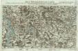
Neue Topographische Carte Der Lahn von Marburg bis zu ihrem Einflus in den Rhein mit Bemerkung der in dieser Gegend vorgefallenen Kriegsbegebenheiten von 1795 und 1796
Brand, Peter; Thum, C.; Schalck, Anna Maria; Coentgen, Georg Joseph Brand u. Thum
Partie Orientale Du Temporel De L'Archevesché et Eslectorat, De Treves
1 : 210000 Mollova mapová sbírka Sanson, Guillaume Jaillot, Alexis Hubert
Archiepiscopatus Coloniensis Pars Australis
1 : 260000 Mollova mapová sbírka Gigas, Johann Michael
Archiepiscopatus Coloniensis Pars Australis
1 : 260000 Mollova mapová sbírka Gigas, Johann Michael

Nassovia Comitatvs
1 : 1300000 Mollova mapová sbírka Hondius, Henricus Hondius, Henricus
Berge Ducatus Marck Comitatus
1 : 240000 Mollova mapová sbírka Schenk, Pieter Schenk, Peter I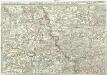
Exactissima totius Vederoviae late sumtae tabula, cujus pars prima est Vederovia stricte sic dicta versus meridiem
1 : 148000 Jülich (Německo) Buna, Wilhelm C.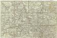
[Exactissima totius Vederoviae late sumtae tabula, cujus pars prima est Vederovia stricte sic dicta versus meridiem]
1 : 148000 Jülich (Německo) Buna, Wilhelm C.
[21] Sec. Siegen, uit: Geologische Karte der Rheinprovinz und der Provinz Westphalen / ausgeführt durch H. von Dechen
1 : 80000 titelvariant: Dechen's geologische Karte vom Rheinland und Westphalen; Annotatie: Titel op bladoverzicht; Incompleet Heinrich von Dechen Berlin : Schropp
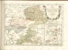
Charte vom Herzogthum Nassau
1 : 200000 Fembo, Christoph
Exactissima totius Vederoviae laté sumtae Tabula
1 : 210000 Mollova mapová sbírka Buna, Wilhelm C. Broenner, Heinrich Ludwig
[Kaart], uit: Relief-Panorama des Rheines
titelvariant: Rhein Panorama von Mainz bis Köln; Annotatie: Omslagtitel: Rhein Panorama von Mainz bis Köln Köln-Ehrenfeld : Hoursch & Bechstedt
Herzogthum Nassau, Landgrafschaft Hessen Homburg und die Freie Stadt Frankfurt
Grosser Hand-Atlas über alle Theile der Erde in 170 Karten Meyer, J. Verlag des Bibliographischen Instituts
Partie Orientale Du Temporel De L'Archevesché et Eslectorat De Treves. [Karte], in: Atlas nouveau, contenant toutes les parties du monde [...], Bd. 1, S. 200.
1 Karte aus Atlas Sanson, Nicolas Jaillot, Alexis Hubert und Mortier, Pieter
NASSOVIA | Comitatus
Salomon Rogiers sculpsit [Amsterdam : Joan Blaeu]
[Kaart], uit: Kleines Relief-Panorama des Rheines
titelvariant: Kleines farbiges Relief-Panorama des Rheines; Annotatie: Titel op omslag: Kleines farbiges Relief-Panorama des Rheines; Met ill. van bezienswaardigheden aan weerszijden van de kaart Köln am Rhein : Hoursch & Bechstedt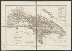
Nassovia Comitatus [Karte], in: Gerardi Mercatoris et I. Hondii Newer Atlas, oder, Grosses Weltbuch, Bd. 1, S. 200.
1 Karte aus Atlas Mercator, Gerhard und Hondius, Jodocus Jansson, Jan
Théatre de la Guerre ou Carte Nouvelle De le Cours du Rhin depuis Worms jusqu'a Bonne et Les Pays Adjacens
1 : 250000 Mollova mapová sbírka Delisle, Guillaume Ottens, Josua
Archiepiscopatus et Electoratus Trevirensis Novissima delineatio
1 : 310000 Mollova mapová sbírka Wit, Frederik de Wit, Frederick