Maps of Oberviechtach

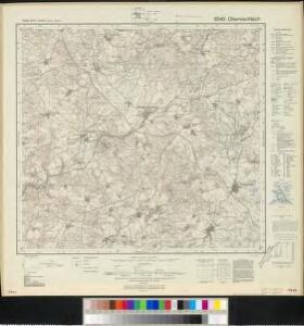
Meßtischblatt 6540 : Oberviechtach, 1941
1 : 250000 Oberviechtach. - Aufn. 1932 u. 1934, hrsg. 1937, letzte Nachtr. 1941, Ausg. 1943. - 1:25000. - München: Hauptvermessungsabt. XIII, 1941. - 1 Kt.
III. vojenské mapování 4249
1 : 75000
Klentsch.
from Spezialkarte der osterreichisch-ungarischen Monarchie.
Kleneč p. Čerchovem
1 : 75000 Klenčí pod Čerchovem-oblast (Česko) Vojenský zeměpisný ústav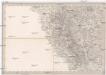
Umgebungen von Klentsch
1 : 750000 Klenčí pod Čerchovem (Česko : oblast) Kiss, Josef K. k. militär-geographisches Institut
Podrobná mapa Království českého
1 : 100000 Pavlův Studenec (Česko : zaniklá obec) Srp, Jan Jaroslav Bursík
Vilímkovy místopisné mapy zemí Koruny české
1 : 100000 Pavlův Studenec (Česko : zaniklá obec) Srp, Jan Jos. R. Vilímek
Klentsch
1 : 75000 Klenčí pod Čerchovem (Česko : oblast) K. u. k. Militärgeographisches Institut
165. Cham, uit: Topographische Uebersichtskarte des Deutschen Reiches / herausgegeben v. d. Kartogr. Abt. d. Königl. Preuß. Landesaufnahme
1 : 200000 titelvariant: Topogr. Übersichtskarte des Deutschen Reiches; Annotatie: Titel boven bladen ook: Topogr. Übersichtskarte des Deutschen Reiches; Annotatie geografische gegevens: Op elk blad twee maatstokken: 10 Kilometer = 5,5 cm; 1 geogr. Meile = 3,6 cm; Legenda onder op elk blad Königlich Preußische Landesaufnahme. Kartographische Abtheilung [S.l : Königlich Preußische Landesaufnahme, Kartographische Abtheilung]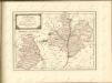
Müllerova mapa Čech
1 : 132000
exhibet Continuationem Partis Palatinatus Super: Regiminis Straubing: et Villam Jmperialem Augusta Tiberii
1 : 150000 Mollova mapová sbírka Buna, Wilhelm C. Broenner, Heinrich Ludwig
Pars II. exhibet continuationem partis palatinatus super: regiminis Straubing: et villam jmperialem Augusta Tiberii
1 Karte : 54 x 52 cm Heinrich Ludwig Broenner
[Böhmerwald und die Umgebung von Eger]
1 : 80000 Cheb-oblast (Česko)
Fischerei-Karte des Radbusa-Gebietes
Radbuza-oblast (Česko) Schubert, Ottokar Deutsche agrarische Druckerei
Sacri Romani imperii circuli et electoratus Bavariae tabula, 2
4 Blätter : s.n.
Mappa geographica regni Bohemiae in duodecim circulos divisae ...
[Nová Mapa království Českého]
1 : 200000 Šumava Kotyška, Václav Hanf, Norbert Bursík & Kohout
Nová Mapa království Českého
1 : 200000 Šumava Kotyška, Václav Hanf, Norbert Bursík & Kohout
Deutsche Strassenprofilkarte für Radfahrer
Furth im Wald (Německo) Mittelbach's Verlag
Nová mapa Království Českého: Jihozápadní Čechy

Charte vom Klattauer Kreise ...

Taus 116, uit: Special-Karte von Mittel-Europa / nach amtlichen Quellen bearbeitet von W. Liebenow
1 : 300000 titelvariant: W. Liebenow's Mittel-Europa; Annotatie: Titel boven de bladen: W. Liebenow's Mittel-Europa Johannes Wilhelm Liebenow 1822-1897 Frankfurt a. M. : Ludwig Ravenstein
Des Herzogthums Oberpfalz nördliche Pfleggerichte mit der gefürsteten Grafschaft Sternstein
1 Karte : Kupferdruck ; 18 x 27 cm Reilly F. J. J. von Reilly

C. Flemming's Karte von Deutsch - Französischen Kriegsschaupltze

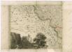
Regni Bohemiae Circuli Pilsen et Klattau Ex Müllerianis aliisque recentissimis subsidiis
Tištěná přehledná mapa Plzeňského a Klatovského kraje vydaná Homannovými dědici podle Müllerovy mapy Čech. Zachycuje sídelní a vodní síť, terén a lesy naznačeny kopečky a stromky. V sousedícím území zaznamenána významnější místa. Označena sídla významnější šlechty (hr. v. Sinzendorf v Plané, premonstráti v Teplé, benediktýní v Kladrubech, Löwenstin v Bezdružicích). Vpravo nahoře v jednoduchém rámci zdobeném vinnými úponky 'SCALA MILLIARIUM.', vpravo dole v rokajovém rámci název, vlevo dole v rokajovém rámci latinské vysvětlivky značek 'Signorum Explicatio'. Značkami rozlišeny 4 typy měst, zámky, 2 typy vsí, kláštery, samoty, mlýny a o samotě stojící kostely.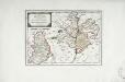
Das Fürstenthum Sulzbach und die Landgrafschaft Leuchtenberg
1 Karte : Kupferdruck ; 19 x 28 cm Reilly F. J. J. von Reilly