Maps of Waldmünchen

Kleneč p. Čerchovem
1 : 75000 Klenčí pod Čerchovem-oblast (Česko) Vojenský zeměpisný ústav
III. vojenské mapování 4249
1 : 75000
Klentsch
1 : 75000 Klenčí pod Čerchovem (Česko : oblast) K. u. k. Militärgeographisches Institut

[Kartenblatt]
1 : 25000 Klenčí pod Čerchovem (Česko : oblast) Reichsamt für Landesaufnahme
[Kartenblatt]
1 : 25000 Bystřice (Česko : zaniklá obec) Reichsamt für Landesaufnahme
III. vojenské mapování 4249/2
1 : 25000
III. vojenské mapování 4249/2
1 : 25000
III. vojenské mapování 4249/2
1 : 25000
Meßtischblatt 6641 : Rötz, 1940
1 : 250000 Rötz. - Aufn. 1929,30, Ausg. 1932, einz. Nachtr. 1940, bereinigt 1940. - 1:25000. - München: Bayer. Topographischen Bureau, Hauptvermessungsabt. XIII, 1940. - 1 Kt.
Meßtischblatt 6540 : Oberviechtach, 1941
1 : 250000 Oberviechtach. - Aufn. 1932 u. 1934, hrsg. 1937, letzte Nachtr. 1941, Ausg. 1943. - 1:25000. - München: Hauptvermessungsabt. XIII, 1941. - 1 Kt.
Gradkartenblatt
1 : 25000 Klenčí pod Čerchovem-oblast (Česko) Bulla, Eduard
Meßtischblatt 6642 : Waldmünchen, 1942
1 : 250000 Waldmünchen. - Aufn. 1927, hrsg. 1930, erkund. 1940, bericht. 1941, bereinigt 1942, Ausg. 1942. - 1:25000. - München: Hauptvermessungsabt. XIII, 1942. - 1 Kt.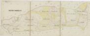
Hospodářská mapa revíru Postřekov
1 : 5338
Přehledná porostní mapa lesů velkostatku Trhanov
1 : 11520
Přehledná lesní mapa velkostatku Trhanov
1 : 11520
Přehledná porostní mapa velkostatku Trhanov
1 : 11520
Mapa panských pozemků v polesí Postřekov
1 : 5760
Porostní mapa revíru Postřekov
1 : 11520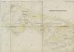
Hospodářská mapa revíru Novosedelské Hutě
1 : 3224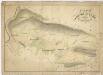
Hospodářské mapa revíru Novosedlské Hutě
1 : 5806
Porotstní mapa revíru Černá Řeka
1 : 5760
Grafenried - c4288-3-004 - Kaiserpflichtexemplar der Landkarten des stabilen Katasters
1 : 2880
Grafenried - c4288-3-005 - Kaiserpflichtexemplar der Landkarten des stabilen Katasters
1 : 2880
Grafenried - c4288-3-002 - Kaiserpflichtexemplar der Landkarten des stabilen Katasters
1 : 2880
Grafenried - c4288-3-007 - Kaiserpflichtexemplar der Landkarten des stabilen Katasters
1 : 2880
Grafenried - c4288-3-006 - Kaiserpflichtexemplar der Landkarten des stabilen Katasters
1 : 2880
Grafenried - c4288-3-001 - Kaiserpflichtexemplar der Landkarten des stabilen Katasters
1 : 2880


