Maps of Runding

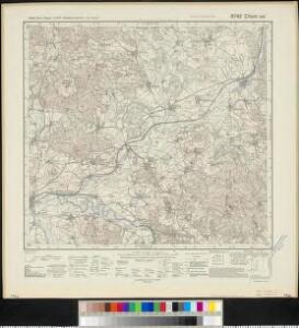
Meßtischblatt 6742 : Cham ost, 1940
1 : 250000 Cham ost. - Aufn. 1928, Ausg. 1931, einzelne Nachtr. 1938, bereinigt 1940. - 1:25000. - München: Hauptvermessungsabt. XIII, 1940. - 1 Kt.
[Kartenblatt]
1 : 25000 Bystřice (Česko : zaniklá obec) Reichsamt für Landesaufnahme
Fortsetzung deren Konigl. Hungar Kriegs Unternehmungen in Bayern darinen alle von 18sten May bis 9ten Juny vorbeygegangenen Operationen deutlich dargestellet seynd
Mollova mapová sbírka Lidl, Johann Jakob Lidl, Johann Jacob
Podrobná mapa království Českého: Brod n. L.-Sv. Kateřina

Podrobná mapa Království českého
1 : 100000 Furth im Wald (Německo) Srp, Jan Jaroslav Bursík
Klentsch.
from Spezialkarte der osterreichisch-ungarischen Monarchie.

Klentsch
1 : 75000 Klenčí pod Čerchovem (Česko : oblast) K. u. k. Militärgeographisches Institut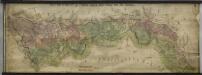
Hraniční mapa-zemská hranice mezi Folmavou a Fleky
1 : 12753
Bairische Landtafeln XXIIII. Darinnē das hochlöblich Furstenthumb Obern unnd Nidern Bayrn sambt der Obern Pflaz Erz unnd Stifft Salzburg Eichstet unnd andern mehrern anstossenden Herschafftē]
1 : 145000 Mollova mapová sbírka Apian, Philipp Amman, Jost Apian, Petrus
165. Cham, uit: Topographische Uebersichtskarte des Deutschen Reiches / herausgegeben v. d. Kartogr. Abt. d. Königl. Preuß. Landesaufnahme
1 : 200000 titelvariant: Topogr. Übersichtskarte des Deutschen Reiches; Annotatie: Titel boven bladen ook: Topogr. Übersichtskarte des Deutschen Reiches; Annotatie geografische gegevens: Op elk blad twee maatstokken: 10 Kilometer = 5,5 cm; 1 geogr. Meile = 3,6 cm; Legenda onder op elk blad Königlich Preußische Landesaufnahme. Kartographische Abtheilung [S.l : Königlich Preußische Landesaufnahme, Kartographische Abtheilung]
Müllerova mapa Čech
1 : 132000
Fischerei-Karte des Radbusa-Gebietes
Radbuza-oblast (Česko) Schubert, Ottokar Deutsche agrarische Druckerei
Nová mapa království Českého
Mappa geographica regni Bohemiae in duodecim circulos divisae ...

Charte vom Klattauer Kreise ...

Charte vom Klattauer Kreise des Königreiches Böheim
1 : 260000 Klatovy-oblast (Česko) Kreibich, František Jakub Jindřich Pluth, Fr. C. W. Enders
Charte vom Klattauer Kreise des Königreiches Böheim
1 : 260000 Klatovy-oblast (Česko) Kreibich, František Jakub Jindřich Pluth, Fr. C. W. Enders
Charte vom Klattauer Kreise des Königreiches Böheim
1 : 246000 Klatovy-oblast (Česko) Kreibich, František Jakub Jindřich Enders, C. W. C.W. Enders
Charte vom Klattauer Kreise des Königreiches Böheim
1 : 246000 Klatovy-oblast (Česko) Kreibich, František Jakub Jindřich Enders, C. W. C.W. Enders
Charte vom Klattauer Kreise des Königreiches Böheim
1 : 246000 Klatovy-oblast (Česko) Kreibich, František Jakub Jindřich Enders, C. W. C.W. Enders
Charte vom Klattauer Kreise des Königreiches Böheim
1 : 246000 Klatovy-oblast (Česko) Kreibich, František Jakub Jindřich Enders, C. W. C.W. Enders
Charte vom Klattauer Kreise des Königreiches Böheim
1 : 246000 Klatovy-oblast (Česko) Kreibich, František Jakub Jindřich Enders, C. W. C.W. Enders
Charte vom Klattauer Kreise des Königreiches Böheim
1 : 246000 Klatovy-oblast (Česko) Kreibich, František Jakub Jindřich Enders, C. W. C.W. Enders
Charte vom Klattauer Kreise des Königreiches Böheim
1 : 246000 Klatovy-oblast (Česko) Kreibich, František Jakub Jindřich Enders, C. W. C.W. Enders
Charte vom Königgrätzer Kreise des Königreiches Böheim
1 : 241000 Hradec Králové-oblast (Česko) Kreibich, František Jakub Jindřich Enders, C. W. C.W. Enders
Charte vom Königgrätzer Kreise des Königreiches Böheim
1 : 260000 Hradec Králové-oblast (Česko) Kreibich, František Jakub Jindřich C. W. Enders
Charte vom Königgrätzer Kreise des Königreiches Böheim
1 : 260000 Hradec Králové-oblast (Česko) Kreibich, František Jakub Jindřich Enders, C. W. C.W. Enders
Charte vom Königgrätzer Kreise des Königreiches Böheim
1 : 260000 Hradec Králové-oblast (Česko) Kreibich, František Jakub Jindřich Enders, C. W. C.W. Enders
Charte vom Königgrätzer Kreise des Königreiches Böheim
1 : 241000 Hradec Králové-oblast (Česko) Kreibich, František Jakub Jindřich Enders, C. W. C.W. Enders
Charte vom Königgrätzer Kreise des Königreiches Böheim
1 : 241000 Hradec Králové-oblast (Česko) Kreibich, František Jakub Jindřich Enders, C. W. C.W. Enders
Charte vom Königgrätzer Kreise des Königreiches Böheim
1 : 241000 Hradec Králové-oblast (Česko) Kreibich, František Jakub Jindřich Enders, C. W. C.W. Enders
Charte vom Königgrätzer Kreise des Königreiches Böheim
1 : 241000 Hradec Králové-oblast (Česko) Kreibich, František Jakub Jindřich Enders, C. W. C.W. Enders
Charte vom Königgrätzer Kreise des Königreiches Böheim
1 : 241000 Hradec Králové-oblast (Česko) Kreibich, František Jakub Jindřich Enders, C. W. C.W. Enders
Charte vom Königgrätzer Kreise des Königreiches Böheim
1 : 260000 Hradec Králové-oblast (Česko) Kreibich, František Jakub Jindřich Kolowrat-Liebsteinský, František Antonín C. W. Enders
Charte vom Königgrätzer Kreise des Königreiches Böheim
1 : 241000 Hradec Králové-oblast (Česko) Kreibich, František Jakub Jindřich Enders, C. W. C.W. Enders
Charte vom Königgrätzer Kreise des Königreiches Böheim
1 : 241000 Hradec Králové-oblast (Česko) Kreibich, František Jakub Jindřich Enders, C. W. C.W. Enders