Maps of Waffenbrunn

[Kartenblatt]
1 : 25000 Bystřice (Česko : zaniklá obec) Reichsamt für Landesaufnahme
Meßtischblatt 6642 : Waldmünchen, 1942
1 : 250000 Waldmünchen. - Aufn. 1927, hrsg. 1930, erkund. 1940, bericht. 1941, bereinigt 1942, Ausg. 1942. - 1:25000. - München: Hauptvermessungsabt. XIII, 1942. - 1 Kt.
III. vojenské mapování 4249/4
1 : 25000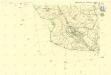
III. vojenské mapování 4249/4
1 : 25000
Gradkartenblatt
1 : 25000 Bystřice (Česko : zaniklá obec) Bulla, Eduard
III. vojenské mapování 4249/4
1 : 25000
Klentsch
1 : 75000 Klenčí pod Čerchovem (Česko : oblast) K. u. k. Militärgeographisches Institut


Meßtischblatt 6742 : Cham ost, 1940
1 : 250000 Cham ost. - Aufn. 1928, Ausg. 1931, einzelne Nachtr. 1938, bereinigt 1940. - 1:25000. - München: Hauptvermessungsabt. XIII, 1940. - 1 Kt.
Porostní mapa revíru hospodářského celku Smrčno
1 : 10000
Meßtischblatt 6641 : Rötz, 1940
1 : 250000 Rötz. - Aufn. 1929,30, Ausg. 1932, einz. Nachtr. 1940, bereinigt 1940. - 1:25000. - München: Bayer. Topographischen Bureau, Hauptvermessungsabt. XIII, 1940. - 1 Kt.
Vollmau Unter - c1279-1-006 - Kaiserpflichtexemplar der Landkarten des stabilen Katasters
1 : 2880
Vollmau Unter - c1279-1-016 - Kaiserpflichtexemplar der Landkarten des stabilen Katasters
1 : 2880
Vollmau Unter - c1279-1-007 - Kaiserpflichtexemplar der Landkarten des stabilen Katasters
1 : 2880
Vollmau Unter - c1279-1-001 - Kaiserpflichtexemplar der Landkarten des stabilen Katasters
1 : 2880
Vollmau Unter - c1279-1-008 - Kaiserpflichtexemplar der Landkarten des stabilen Katasters
1 : 2880
Vollmau Unter - c1279-1-011 - Kaiserpflichtexemplar der Landkarten des stabilen Katasters
1 : 2880
Vollmau Unter - c1279-1-012 - Kaiserpflichtexemplar der Landkarten des stabilen Katasters
1 : 2880
Vollmau Unter - c1279-1-010 - Kaiserpflichtexemplar der Landkarten des stabilen Katasters
1 : 2880
Vollmau Unter - c1279-1-019 - Kaiserpflichtexemplar der Landkarten des stabilen Katasters
1 : 2880
Vollmau Unter - c1279-1-017 - Kaiserpflichtexemplar der Landkarten des stabilen Katasters
1 : 2880
Vollmau Unter - c1279-1-013 - Kaiserpflichtexemplar der Landkarten des stabilen Katasters
1 : 2880
Vollmau Unter - c1279-1-015 - Kaiserpflichtexemplar der Landkarten des stabilen Katasters
1 : 2880
Vollmau Unter - c1279-1-003 - Kaiserpflichtexemplar der Landkarten des stabilen Katasters
1 : 2880
Vollmau Unter - c1279-1-009 - Kaiserpflichtexemplar der Landkarten des stabilen Katasters
1 : 2880
Vollmau Unter - c1279-1-014 - Kaiserpflichtexemplar der Landkarten des stabilen Katasters
1 : 2880
Vollmau Unter - c1279-1-020 - Kaiserpflichtexemplar der Landkarten des stabilen Katasters
1 : 2880
Vollmau Unter - c1279-1-005 - Kaiserpflichtexemplar der Landkarten des stabilen Katasters
1 : 2880
Vollmau Unter - c1279-1-004 - Kaiserpflichtexemplar der Landkarten des stabilen Katasters
1 : 2880
Vollmau Unter - c1279-1-002 - Kaiserpflichtexemplar der Landkarten des stabilen Katasters
1 : 2880
![[Kartenblatt]](https://images-2.georeferencer.com/images/iiif/645389053369/full/,300/0/native.jpg)

