Maps of Münster

Composite: 330. Munster.
1 : 100000 Reichsamt fur Landesaufnahme
Meßtischblatt 2287 : Sendenhorst, 1910
1 : 250000 Sendenhorst. - Aufn. 1895, hrsg. 1897, einz. Nachtr. 1910. - 1:25000. - [Berlin]: Reichsamt für Landesaufnahme, 1910. - 1 Kt.
Meßtischblatt 2286 : Ottmarsbocholt, 1927
1 : 250000 Ottmarsbocholt. - Aufn. 1895, hrsg. 1897, einz. Nachtr. 1927. - 1:25000. - [Berlin]: Reichsamt für Landesaufnahme, 1927. - 1 Kt.
Meßtischblatt 2286 : Ottmarsbocholt, 1897
1 : 250000 Ottmarsbocholt. - Aufn. 1895. - 1:25000. - [Berlin]: Reichsamt für Landesaufnahme, 1897. - 1 Kt.
Meßtischblatt 2285 : Buldern, 1897
1 : 250000 Buldern. - Aufn. 1895. - 1:25000. - [Berlin]: Reichsamt für Landesaufnahme, 1897. - 1 Kt.
Meßtischblatt 2214 : Telgte, 1907
1 : 250000 Telgte. - Aufn. 1895, hrsg. 1897, einz. Nachtr. 1907. - 1:25000. - [Berlin]: Reichsamt für Landesaufnahme, 1907. - 1 Kt.
Meßtischblatt 2213 : Münster in Westfalen, 1927
1 : 250000 Münster in Westfalen. - Aufn. 1895, bericht. 1922, einz. Nachtr. 1927. - 1:25000. - [Berlin]: Reichsamt für Landesaufnahme, 1927. - 1 Kt.
Meßtischblatt 2212 : Nottuln, 1914
1 : 250000 Nottuln. - Aufn. 1895, hrsg. 1897, Aufl.-dr. 1914. - 1:25000. - [Berlin]: Reichsamt für Landesaufnahme, 1914. - 1 Kt.
Meßtischblatt 2212 : Nottuln, 1897
1 : 250000 Nottuln. - Aufn. 1895. - 1:25000. - [Berlin]: Reichsamt für Landesaufnahme, 1897. - 1 Kt.
Meßtischblatt 2361 : Drensteinfurt, 1927
1 : 250000 Drensteinfurt. - Aufn. 1892, bericht. 1927. - 1:25000. - [Berlin]: Reichsamt für Landesaufnahme, 1927. - 1 Kt.
Meßtischblatt 2361 : Drensteinfurt, 1907
1 : 250000 Drensteinfurt. - Aufn. 1892, hrsg. 1894, bericht. 1907. - 1:25000. - [Berlin]: Reichsamt für Landesaufnahme, 1907. - 1 Kt.
Meßtischblatt 2361 : Drensteinfurt, 1894
1 : 250000 Drensteinfurt. - Aufn. 1892. - 1:25000. - [Berlin]: Reichsamt für Landesaufnahme, 1894. - 1 Kt.
Meßtischblatt 2360 : Ascheberg, 1894
1 : 250000 Ascheberg. - Aufn. 1892. - 1:25000. - [Berlin]: Reichsamt für Landesaufnahme, 1894. - 1 Kt.
Meßtischblatt 2359 : Lüdinghausen, 1927
1 : 250000 Lüdinghausen. - Aufn. 1892, bericht. 1927. - 1:25000. - [Berlin]: Reichsamt für Landesaufnahme, 1927. - 1 Kt.
Meßtischblatt 2359 : Lüdinghausen, 1911
1 : 250000 Lüdinghausen. - Aufn. 1892, hrsg. 1894, bericht. 1907, [gedr.] [19]11. - 1:25000. - [Berlin]: Reichsamt für Landesaufnahme, 1911. - 1 Kt.
Meßtischblatt 2359 : Lüdinghausen, 1894
1 : 250000 Lüdinghausen. - Aufn. 1892. - 1:25000. - [Berlin]: Reichsamt für Landesaufnahme, 1894. - 1 Kt.
[Recto], uit: Pharus-Plan Münster i/W.
1 : 10100 Berlin : Pharus-Verlag [etc.]
Monasterivm
Merian, Matthaeus (der Ältere) [Merian]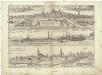
Monasterivm, vrbs in media Westphalia celeberrimi nominis, metropolitica dignitate, et episcopatu clara
Münster in Westfalen (Německo) Braun, Georg Hogenberg, Franz
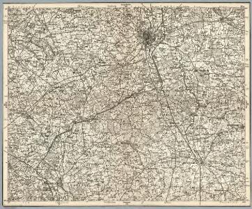
330. Munster.
1 : 100000 Reichsamt fur Landesaufnahme
97. Münster i/Wf., uit: Topographische Uebersichtskarte des Deutschen Reiches / herausgegeben v. d. Kartogr. Abt. d. Königl. Preuß. Landesaufnahme
1 : 200000 titelvariant: Topogr. Übersichtskarte des Deutschen Reiches; Annotatie: Titel boven bladen ook: Topogr. Übersichtskarte des Deutschen Reiches; Annotatie geografische gegevens: Op elk blad twee maatstokken: 10 Kilometer = 5,5 cm; 1 geogr. Meile = 3,6 cm; Legenda onder op elk blad Königlich Preußische Landesaufnahme. Kartographische Abtheilung [S.l : Königlich Preußische Landesaufnahme, Kartographische Abtheilung]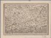
[16], uit: Hydro-Oro und Chorographische General Karte des Koenigreichs der Niederlande und der angrenzenden Länder bis Paris : mit der Angabe der Kunst und Heer-Strassen und der Entfernung der Poststationen / ... zusammengetragen und reducirt von ... Wilhelm Müller
1 : 400000 titelvariant: Generalkarte des Koenigreichs Hannover; Annotatie: 1e supplement bij: Generalkarte des Koenigreichs Hannover (1818) Müller, Wilhelm (fl. 1818) [Hannover : Wilhelm Müller]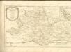

Episcopatvs Monasteriensis Pars Avstralis
1 : 290000 Mollova mapová sbírka Gigas, Johann Michael
Episcopatvs Monasteriensis Pars Avstralis
1 : 290000 Mollova mapová sbírka Gigas, Johann Michael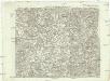
Carte topographique d'Allemagne
1 : 225000 Dortmund (Německo) Facius, Johann Gottlieb ches I.W.A. Iaeger
Haute Partie De L'Evesché De Munster subdivisé en ses principales Iuridictions. [Karte], in: Atlas nouveau, contenant toutes les parties du monde [...], Bd. 1, S. 303.
1 Karte aus Atlas Sanson, Nicolas Jaillot, Alexis Hubert und Mortier, Pieter
Haute Partie de l'Evesché de Munster subdivisé en ses principales Iuridictios
1 : 300000 Mollova mapová sbírka Sanson, Guillaume Jaillot, Alexis Hubert
Tetrarchia Ducatus Geldriae Neomagensis
1 : 150000 Mollova mapová sbírka Wit, Frederik de Covens, Johannes I