Maps of Drensteinfurt

Maps of Drensteinfurt

$title$

Meßtischblatt 2361 : Drensteinfurt, 1927

1 : 250000 Drensteinfurt. - Aufn. 1892, bericht. 1927. - 1:25000. - [Berlin]: Reichsamt für Landesaufnahme, 1927. - 1 Kt.
$title$

Meßtischblatt 2361 : Drensteinfurt, 1907

1 : 250000 Drensteinfurt. - Aufn. 1892, hrsg. 1894, bericht. 1907. - 1:25000. - [Berlin]: Reichsamt für Landesaufnahme, 1907. - 1 Kt.
$title$

Meßtischblatt 2361 : Drensteinfurt, 1894

1 : 250000 Drensteinfurt. - Aufn. 1892. - 1:25000. - [Berlin]: Reichsamt für Landesaufnahme, 1894. - 1 Kt.
$title$

Composite: 330. Munster.

1 : 100000 Reichsamt fur Landesaufnahme
$title$

330. Munster.

1 : 100000 Reichsamt fur Landesaufnahme
$title$

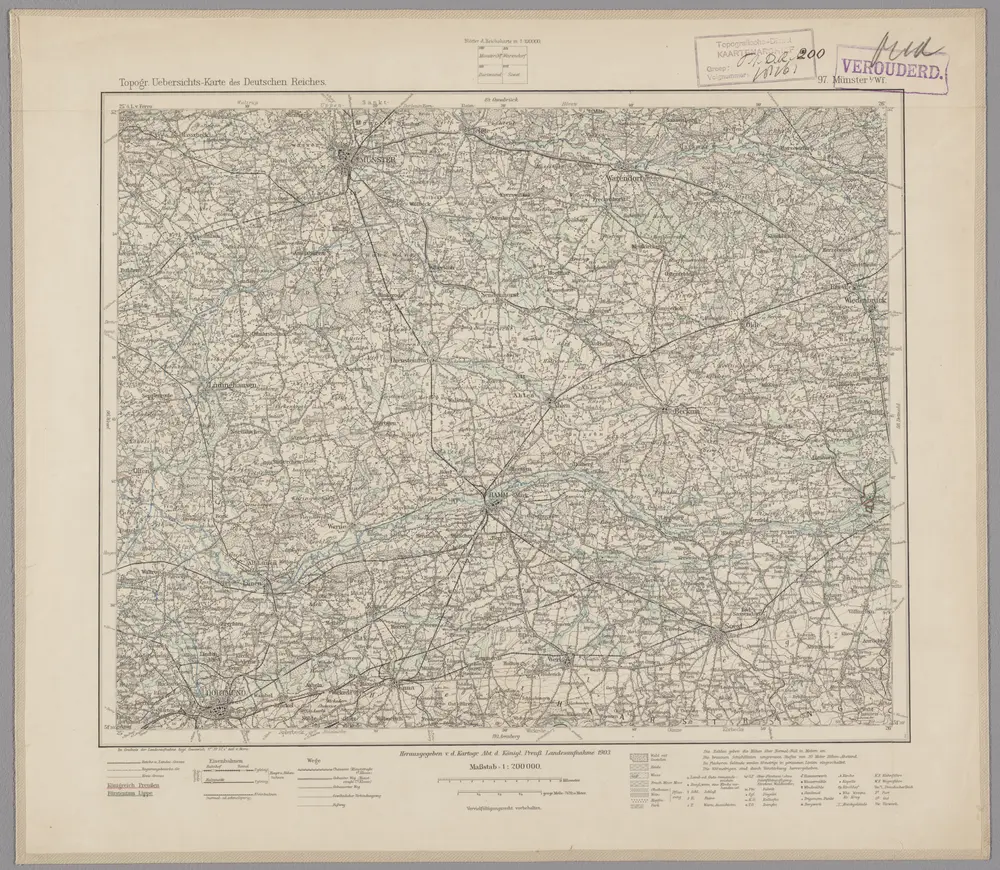
97. Münster i/Wf., uit: Topographische Uebersichtskarte des Deutschen Reiches / herausgegeben v. d. Kartogr. Abt. d. Königl. Preuß. Landesaufnahme

1 : 200000 titelvariant: Topogr. Übersichtskarte des Deutschen Reiches; Annotatie: Titel boven bladen ook: Topogr. Übersichtskarte des Deutschen Reiches; Annotatie geografische gegevens: Op elk blad twee maatstokken: 10 Kilometer = 5,5 cm; 1 geogr. Meile = 3,6 cm; Legenda onder op elk blad Königlich Preußische Landesaufnahme. Kartographische Abtheilung [S.l : Königlich Preußische Landesaufnahme, Kartographische Abtheilung]
$title$

Le Theatre de Bellone :

Mollova mapová sbírka Schenk, Pieter Braakman, Adriaan
$title$

307. Iburg.

1 : 100000 Reichsamt fur Landesaufnahme
$title$

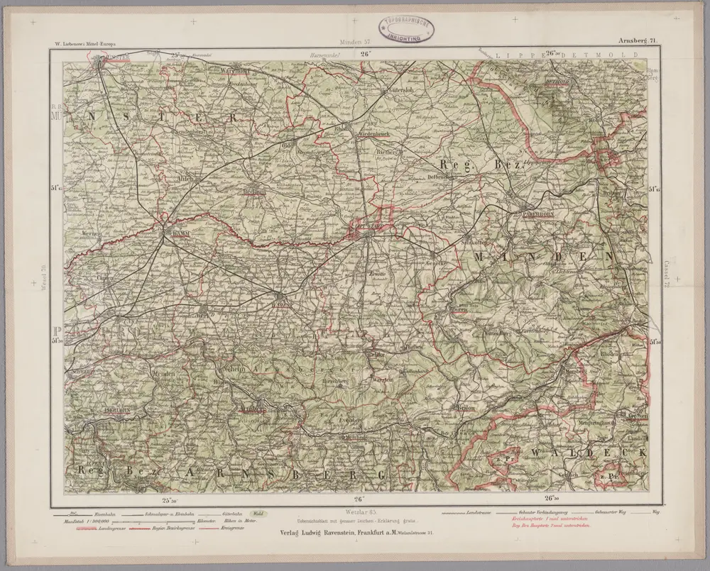
Arnsberg 71, uit: Special-Karte von Mittel-Europa / nach amtlichen Quellen bearbeitet von W. Liebenow

1 : 300000 titelvariant: W. Liebenow's Mittel-Europa; Annotatie: Titel boven de bladen: W. Liebenow's Mittel-Europa Johannes Wilhelm Liebenow 1822-1897 Frankfurt a. M. : Ludwig Ravenstein
$title$

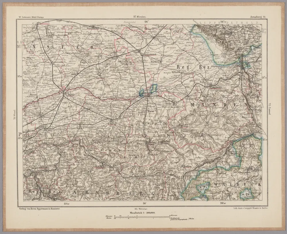
Arnsberg 71, uit: [W. Liebenow's Special-Karte von Mittel-Europa]

1 : 300000 titelvariant: W. Liebenow's Mittel-Europa; Annotatie: Titel boven de bladen: W. Liebenow's Mittel-Europa Johannes Wilhelm Liebenow 1822-1897 Hannover : Hermann Oppermann
$title$

[16], uit: Hydro-Oro und Chorographische General Karte des Koenigreichs der Niederlande und der angrenzenden Länder bis Paris : mit der Angabe der Kunst und Heer-Strassen und der Entfernung der Poststationen / ... zusammengetragen und reducirt von ... Wilhelm Müller

1 : 400000 titelvariant: Generalkarte des Koenigreichs Hannover; Annotatie: 1e supplement bij: Generalkarte des Koenigreichs Hannover (1818) Müller, Wilhelm (fl. 1818) [Hannover : Wilhelm Müller]
$title$

Westphalia ducatus

1 : 276000 Vestfálsko (Německo) Gigas, Johann Michael Blaeu, Willem Janszoon Guiljelmus Blaeuw excudit
$title$

$title$

Episcopatvs Monasteriensis Pars Avstralis

1 : 290000 Mollova mapová sbírka Gigas, Johann Michael
$title$

Episcopatvs Monasteriensis Pars Avstralis

1 : 290000 Mollova mapová sbírka Gigas, Johann Michael
$title$

Carte topographique d'Allemagne

1 : 225000 Dortmund (Německo) Facius, Johann Gottlieb ches I.W.A. Iaeger
$title$

Ducatvs Westphaliae nova repraesentatio geographica

1 : 200000 Mollova mapová sbírka Sittartz, Josef Homann, Johann Baptista - dědici
$title$

Ducatus Westphalia

1 : 220000 Mollova mapová sbírka Seutter, Matthäus Seutter, Matthäus
$title$

Tetrarchia Ducatus Geldriae Neomagensis

1 : 150000 Mollova mapová sbírka Wit, Frederik de Covens, Johannes I
$title$

Haute Partie De L'Evesché De Munster subdivisé en ses principales Iuridictions. [Karte], in: Atlas nouveau, contenant toutes les parties du monde [...], Bd. 1, S. 303.

1 Karte aus Atlas Sanson, Nicolas Jaillot, Alexis Hubert und Mortier, Pieter
$title$

Haute Partie de l'Evesché de Munster subdivisé en ses principales Iuridictios

1 : 300000 Mollova mapová sbírka Sanson, Guillaume Jaillot, Alexis Hubert
$title$

Coloniensis Archiepiscopatus

1 : 560000 Mollova mapová sbírka Merian, Matthaeus Merian, Matthäus
$title$

Monasteriensis et Osnabvrgensis Episcopatvs

1 : 490000 Mollova mapová sbírka Maschop, Gottfried
$title$

Berge ducatus, Marck comitatus / [Henricus Hondius]

1 : 250000 Annotatie: Het eerst verschenen in: Gerardi Mercatoris et I. Hondii atlas appendix ... - Ambsterdam : bey Johan Jansson, 1636; Origineel is Blad 70 in atlas factice; Met inzet van de omgeving van Soest; Annotatie geografische gegevens: Noordoost boven Hondius, Henricus Amstelodami : sumptibus Henrici Hondii
$title$

$title$

Rev.mo et Seren.mo Principi ac Domo. Dn. Ferdinando Archiep. et Elect. Colon. Episcop. Monasteriens Leto, Duci Bavariae

Mollova mapová sbírka Gigas, Johann Michael
$title$

Berge Ducatus Marck Comitatus. [Karte], in: Gerardi Mercatoris et I. Hondii Newer Atlas, oder, Grosses Weltbuch, Bd. 1, S. 188.

1 Karte aus Atlas Mercator, Gerhard und Hondius, Jodocus Jansson, Jan
$title$

Celssissimo Potentissimo Invictissimoq; Principi Frederico Guilielmo II. D. G. Marchioni Brandenburgico S. R. I. Electori ac Archicamerario etc. Hanc Exactissimam Cliviae Ducatus et Marchiae Comitatus Tabulam Humillime Offert

1 : 320000 Mollova mapová sbírka Wit, Frederik de Wit, Frederick
$title$

Tabula Geographica Partem Inferioris Rheni continens, in qua sunt Ducatus Clivensis, Archiepiscopatus Coloniensis, Ducatus Montensis et Comitatus Marchiensis

1 : 310000 Mollova mapová sbírka Visscher, Nicolaes Jansz. Schenk, Peter II
$title$

Monasteriensis Episcopatvs

1 : 470000 Mollova mapová sbírka Schenk, Pieter Schenk, Peter I
$title$

Carta del Vescovato di Mvnster

1 : 450000 Mollova mapová sbírka Hacque, Johann Baptist
$title$

Monasteriensis Episcopatus

1 : 460000 Mollova mapová sbírka Hondius, Jodocus Hondius, Jodocus
$title$

Monasteriensis Episcopatvs

1 : 460000 Mollova mapová sbírka Gigas, Johann Michael Blaeu, Joan I.
$title$

Monasteriensis Episcopatus

1 : 460000 Mollova mapová sbírka Gigas, Johann Michael Blaeu, Willem Jansz.
© MapTiler © OpenStreetMap contributors
How does it work?
These instructions will show you how to find historical maps online.
Getting started
Type the place name in the search box to find the exact location. You can further adjust the search by zooming in and out.
Zoom
Zoom in and out with the buttons or use your mouse or touchpad natively.
Exact Area tool
Click here and draw a rectangle over the map to precisely define the search area.
Set filters
Narrow your search with advanced settings, such as Years (from/to), Fulltext, Publisher, etc.
Results
See the results of your search on the right side. You can scroll down to find more maps of this location.
?

Download OldMapsOnline Mobile