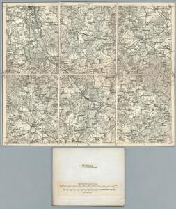
Maps of Bienenbüttel

210. Lunenburg. (Germany)
1 : 100000 Reichsamt fur Landesaufnahme
Meßtischblatt 1382 : Altenmedingen, 1901
1 : 250000 Altenmedingen. - Aufn. 1899. - 1:25000. - [Berlin]: Reichsamt für Landesaufnahme, 1901. - 1 Kt.
Meßtischblatt 1383 : Dahlenburg, 1901
1 : 250000 Dahlenburg. - Aufn. 1899. - 1:25000. - [Berlin]: Reichsamt für Landesaufnahme, 1901. - 1 Kt.
Meßtischblatt 1381 : Bienenbüttel, 1919
1 : 250000 Bienenbüttel. - Aufn. 1899, Nachtr. 1919. - 1:25000. - [Berlin]: Reichsamt für Landesaufnahme, 1919. - 1 Kt.
Meßtischblatt 1462 : Bevensen, 1924
1 : 250000 Bevensen. - Aufn. 1899, Nachtr. 1924. - 1:25000. - [Berlin]: Reichsamt für Landesaufnahme, 1924. - 1 Kt.
Meßtischblatt 1463 : Himbergen, 1924
1 : 250000 Himbergen. - Aufn. 1899, Nachtr. 1924. - 1:25000. - [Berlin]: Reichsamt für Landesaufnahme, 1924. - 1 Kt.
Meßtischblatt 1461 : Ebstorf, 1901
1 : 250000 Ebstorf. - Aufn. 1899. - 1:25000. - [Berlin]: Reichsamt für Landesaufnahme, 1901. - 1 Kt.
Meßtischblatt 1301 : Neetze, 1901
1 : 250000 Neetze. - Aufn. 1879/99, hrsg. 1901. - 1:25000. - [Berlin]: Reichsamt für Landesaufnahme, 1901. - 1 Kt.
Meßtischblatt 1302 : Bleckede, 1901
1 : 250000 Bleckede. - Aufn. 1879/99. - 1:25000. - [Berlin]: Reichsamt für Landesaufnahme, 1901. - 1 Kt.
Meßtischblatt 1300 : Lüneburg, 1910
1 : 250000 Lüneburg. - bericht. 1899, einz. Nachtr. 1910. - 1:25000. - [Berlin]: Reichsamt für Landesaufnahme, 1910. - 1 Kt.
Meßtischblatt 1300 : Lüneburg, 1881
1 : 250000 Lüneburg. - Aufn. 1879. - 1:25000. - [Berlin]: Reichsamt für Landesaufnahme, 1881. - 1 Kt.
Germany 1:25,000, Luneberg
Germany 1:25,000 , Series GSGS 4414. Great Britain. War Office. [London] : War Office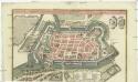
Lüneburgum ad flumen Elmenaw, ex ruderibus Bardovicensibus aucta, in Societatem Hansaeticarum recepta, hodie in ditione regis Angliae et electoris Hanoveranensis posita
Lüneburg (Německo) Seutter, Matthäus Matth. Seutter
Composite: 210. Lunenburg. (Germany)
1 : 100000 Reichsamt fur Landesaufnahme
58. Lauenburg a.d. Elbe, uit: Topographische Uebersichtskarte des Deutschen Reiches / herausgegeben v. d. Kartogr. Abt. d. Königl. Preuß. Landesaufnahme
1 : 200000 titelvariant: Topogr. Übersichtskarte des Deutschen Reiches; Annotatie: Titel boven bladen ook: Topogr. Übersichtskarte des Deutschen Reiches; Annotatie geografische gegevens: Op elk blad twee maatstokken: 10 Kilometer = 5,5 cm; 1 geogr. Meile = 3,6 cm; Legenda onder op elk blad Königlich Preußische Landesaufnahme. Kartographische Abtheilung [S.l : Königlich Preußische Landesaufnahme, Kartographische Abtheilung]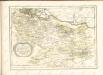

Carte topographique d'Allemagne
1 : 214500 Braniborsko (Německo) Jaeger, Johann Wilhelm Abraham Berndt, Johann Christoph I.W.A. Iaeger
Lüneburg 45, uit: Special-Karte von Mittel-Europa / nach amtlichen Quellen bearbeitet von W. Liebenow
1 : 300000 titelvariant: W. Liebenow's Mittel-Europa; Annotatie: Titel boven de bladen: W. Liebenow's Mittel-Europa Johannes Wilhelm Liebenow 1822-1897 Frankfurt a. M. : Ludwig Ravenstein
Lüneburg 45, uit: [W. Liebenow's Special-Karte von Mittel-Europa]
1 : 300000 titelvariant: W. Liebenow's Mittel-Europa; Annotatie: Titel boven de bladen: W. Liebenow's Mittel-Europa Johannes Wilhelm Liebenow 1822-1897 Hannover : Hermann Oppermann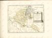

Composite: 211. Dannenberg. (Germany)
1 : 100000 Reichsamt fur Landesaufnahme
179. Lauenburg a. d. Elbe. (Germany)
1 : 100000 Reichsamt fur Landesaufnahme
211. Dannenberg. (Germany)
1 : 100000 Reichsamt fur Landesaufnahme
Composite: 179. Lauenburg a. d. Elbe. (Germany)
1 : 100000 Reichsamt fur Landesaufnahme
Composite: 209. Amelinghausen. (Germany)
1 : 100000 Reichsamt fur Landesaufnahme

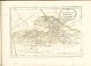
Ducatus Luneburgicus cum comitatu Dannebergensi
1 : 336000 Lüneburg (Německo) Seutter, Matthäus Matth. Seutter