Maps of Hagenow-Land

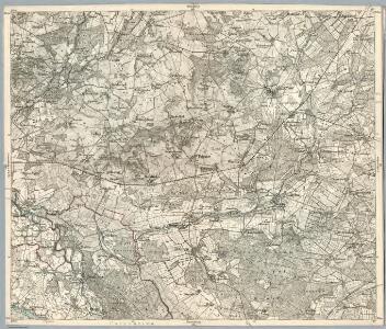
Composite: 180. Hagenow. (Germany)
1 : 100000 Reichsamt fur Landesaufnahme
180. Hagenow. (Germany)
1 : 100000 Reichsamt fur Landesaufnahme
Meßtischblatt 2633 : Redefin, 1952
1 : 250000 Redefin. - Hrsg. 1881, Ausgabe 1938. - 1:25000. - [S.l.]: Vermessungsdienst des Landes Sachsen-Anhalt, 1952. - 1 Kt.
Meßtischblatt 1219 : Lübtheen, 1881
1 : 250000 Lübtheen. - Aufn. 1879. - 1:25000. - [Berlin]: Kgl. Preuss. Landesaufnahme, 1881. - 1 Kt.
Meßtischblatt 1218 : Besitz, 1912
1 : 250000 Besitz. - Aufn. 1879, hrsg. 1881 [bericht. 1904], einz. Nachtr. 1912. - 1:25000. - [Berlin]: Reichsamt für Landesaufnahme, 1912. - 1 Kt.
Meßtischblatt 2533 : Hagenow, 1950
1 : 250000 Hagenow. - Hrsg. 1881, Ausgabe 1918. - 1:25000. - [S.l.]: Landesregierung Sachsen-Anhalt, Anstalt für Kartographie und Kartendruck, 1950. - 1 Kt.
Meßtischblatt 2532 : Körchow, 1908
1 : 250000 Körchow. - Hrsg. 1881, Ausg. 1908. - 1:25000. - [Berlin]: Reichsamt für Landesaufnahme, 1908. - 1 Kt.
Meßtischblatt 2531 : Camin, 1952
1 : 250000 Camin. - Hrsg. 1881, einz. Nachtr. 1913, Ausgabe 1913. - 1:25000. - [S.l.]: Vermessungsdienst des Landes Sachsen-Anhalt, 1952. - 1 Kt.
Meßtischblatt 2733 : Leussow, 1939
1 : 250000 Leussow. - Hrsg. 1881, ber. 1906, einz. Nachtr. 1939. - 1:25000. - [Berlin]: Reichsamt für Landesaufnahme, 1939. - 1 Kt.
Meßtischblatt 2732 : Jessenitz, 1953
1 : 250000 Jessenitz. - Hrsg. 1900, bericht. 1906, letzte Nachtr. 1939. - 1:25000. - [S.l.]: 1953. - 1 Kt.
Meßtischblatt 1303 : Neuhaus a. d. Elbe, 1938
1 : 250000 Neuhaus a. d. Elbe. - Hrsg. 1881, bericht. 1906, einz. Nachtr. 1919, redakt. Änd. 1938. - 1:25000. - [Berlin]: Reichsamt für Landesaufnahme, 1938. - 1 Kt.
Meßtischblatt 1303 : Neuhaus a. d. Elbe, 1913
1 : 250000 Neuhaus a. d. Elbe. - Aufn. 1879, hrsg. 1881, Auflagedr. 1913. - 1:25000. - [Berlin]: Reichsamt für Landesaufnahme, 1913. - 1 Kt.
58. Lauenburg a.d. Elbe, uit: Topographische Uebersichtskarte des Deutschen Reiches / herausgegeben v. d. Kartogr. Abt. d. Königl. Preuß. Landesaufnahme
1 : 200000 titelvariant: Topogr. Übersichtskarte des Deutschen Reiches; Annotatie: Titel boven bladen ook: Topogr. Übersichtskarte des Deutschen Reiches; Annotatie geografische gegevens: Op elk blad twee maatstokken: 10 Kilometer = 5,5 cm; 1 geogr. Meile = 3,6 cm; Legenda onder op elk blad Königlich Preußische Landesaufnahme. Kartographische Abtheilung [S.l : Königlich Preußische Landesaufnahme, Kartographische Abtheilung]
Meßtischblatt 2431 : Zarrentin, 1953
1 : 250000 Zarrentin. - Hrsg. 1881, Ausg. 1938. - 1:25000. - [S.l.]: VD S-A, 1953. - 1 Kt.
Meßtischblatt 2432 : Wittenburg, 1881
1 : 250000 Wittenburg. - Aufn. 1879. - 1:25000. - [Berlin]: Reichsamt für Landesaufnahme, 1881. - 1 Kt.
Meßtischblatt 2433 : Parum, 1943
1 : 250000 Parum. - Aufn. 1879, hrsg. 1881, letzte Nachtr. 1943. - 1:25000. - [Berlin]: Reichsamt für Landesaufnahme, 1943. - 1 Kt.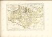

Mappa Ducatus Megalopolitani Nova :
1 : 190000 Mollova mapová sbírka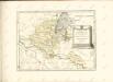

Schwerin 34, uit: Special-Karte von Mittel-Europa / nach amtlichen Quellen bearbeitet von W. Liebenow
1 : 300000 titelvariant: W. Liebenow's Mittel-Europa; Annotatie: Titel boven de bladen: W. Liebenow's Mittel-Europa Johannes Wilhelm Liebenow 1822-1897 Frankfurt a. M. : Ludwig Ravenstein
Composite: 148. Wittenburg. (Germany)
1 : 100000 Reichsamt fur Landesaufnahme
148. Wittenburg. (Germany)
1 : 100000 Reichsamt fur Landesaufnahme
181. Ludwigslust. (Germany)
1 : 100000 Reichsamt fur Landesaufnahme
Composite: 181. Ludwigslust. (Germany)
1 : 100000 Reichsamt fur Landesaufnahme
Meßtischblatt 2534 : Lüblow, 1951
1 : 250000 Lüblow. - Hrsg. 1881, Ausgabe 1904. - 1:25000. - [S.l.]: Landesregierung Sachsen-Anhalt, Anstalt für Kartographie und Kartendruck, 1951. - 1 Kt.
Meßtischblatt 2634 : Ludwigslust, 1952
1 : 250000 Ludwigslust. - Hrsg. 1881, Ausg. 1911, gedr. 1936. - 1:25000. - [S.l.]: Landesregierung Sachsen-Anhalt, Min. des Innern. Abt. Vermessung, 1952. - 1 Kt.
Meßtischblatt 2734 : Eldena, 1957
1 : 250000 Eldena. - Hrsg. 1881, Ausg. 1919, gedr. [19]37. - 1:25000. - [S.l.]: VD Nord, 1957. - 1 Kt.
Meßtischblatt 2434 : Sülstorf, 1881
1 : 250000 Sülstorf. - Aufn. 1879. - 1:25000. - [Berlin]: Reichsamt für Landesaufnahme, 1881. - 1 Kt.