Maps of Lubmin

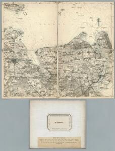
89. Greifswald. (Germany)
1 : 100000 Reichsamt fur Landesaufnahme
Composite: 89. Greifswald. (Germany)
1 : 100000 Reichsamt fur Landesaufnahme
[Greifswald]
Greifswald
Meßtischblatt 1948 : Wolgast, 1939
1 : 250000 Wolgast. - Hrsg. 1887, bericht. 1925. - 1:25000. - [Berlin]: Reichsamt für Landesaufnahme, 1939. - 1 Kt.
Meßtischblatt 594 : Hanshagen, 1887
1 : 250000 Hanshagen. - Aufn. 1885. - 1:25000. - [Berlin]: Reichsamt für Landesaufnahme, 1887. - 1 Kt.
Meßtischblatt 1946 : Greifswald, 1939
1 : 250000 Greifswald. - Hrsg. 1886. - 1:25000. - [Berlin]: Reichsamt für Landesaufnahme, 1939. - 1 Kt.
Meßtischblatt 1848 : Cröslin, 1933
1 : 250000 Cröslin. - Hrsg. 1886, bericht. 1925. - 1:25000. - [Berlin]: Reichsamt für Landesaufnahme, 1933. - 1 Kt.
Meßtischblatt 516, neue Nr. 1848 : Cröslin, 1886
1 : 250000 Cröslin. - Aufn. 1885, hrsg. 1886. - 1:25000. - [Berlin]: Reichsamt für Landesaufnahme, 1886. - 1 Kt.
Meßtischblatt 515 : Wusterhusen, 1925
1 : 250000 Wusterhusen. - Aufn. 1885, hrsg. 1886, bericht. 1925. - 1:25000. - [Berlin]: Reichsamt für Landesaufnahme, 1925. - 1 Kt.
Meßtischblatt 514 : Neuenkirchen (Kr. Greifswald), 1932
1 : 250000 Neuenkirchen (Kr. Greifswald). - Hrsg. 1887, bericht. 1920, einz. Nachtr. 1932. - 1:25000. - [Berlin]: Reichsamt für Landesaufnahme, 1932. - 1 Kt.
Meßtischblatt 514 : Neuenkirchen (Kr. Greifswald), 1920
1 : 250000 Neuenkirchen (Kr. Greifswald). - Aufn. 1885, bericht. 1920. - 1:25000. - [Berlin]: Reichsamt für Landesaufnahme, 1920. - 1 Kt.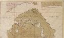
Afteekening van de Pennemünder Schans geleegen bezuijden 't incoomen van 't eijland Rügen
Germany Gerard van Keulen
Das Pommerische Kriegs Theatrum
1 : 200000 Mollova mapová sbírka Krügner, Johann Gottfried Boetius, Johann Theodor
27. Greifswald, uit: Topographische Uebersichtskarte des Deutschen Reiches / herausgegeben v. d. Kartogr. Abt. d. Königl. Preuß. Landesaufnahme
1 : 200000 titelvariant: Topogr. Übersichtskarte des Deutschen Reiches; Annotatie: Titel boven bladen ook: Topogr. Übersichtskarte des Deutschen Reiches; Annotatie geografische gegevens: Op elk blad twee maatstokken: 10 Kilometer = 5,5 cm; 1 geogr. Meile = 3,6 cm; Legenda onder op elk blad Königlich Preußische Landesaufnahme. Kartographische Abtheilung [S.l : Königlich Preußische Landesaufnahme, Kartographische Abtheilung]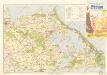
Bäderkarte Usedom

Rugia Insula Ac Ducatus
1 : 240000 Mollova mapová sbírka Lubin, Eilhard Covens, Johannes I
Rugia Insula Ac Ducatus
1 : 265000 Mollova mapová sbírka Lubin, Eilhard Schenk, Peter I
Rugia Insula Ac Ducatus
1 : 240000 Mollova mapová sbírka Lubin, Eilhard Blaeu, Joan I.
Rugia Insula Ac Ducatus
1 : 525000 Mollova mapová sbírka Merian, Matthäus Merian, Matthäus
Rugia Insula Ac Ducatus
1 : 265000 Mollova mapová sbírka Lubin, Eilhard Janssonius, Johannes I
Meßtischblatt 1746 : Zudar, 1937
1 : 250000 Zudar. - Hrsg. 1886, bericht. 1925. - 1:25000. - [Berlin]: Reichsamt für Landesaufnahme, 1937. - 1 Kt.
Meßtischblatt 442, neue Nr. 1747 : Zickersches Höft, 1937
1 : 250000 Zickersches Höft. - Hrsg. 1886, bericht. 1925. - 1:25000. - [Berlin]: Reichsamt für Landesaufnahme, 1937. - 1 Kt.
Meßtischblatt 443 : Gr. Zicker, 1925
1 : 250000 Gr. Zicker. - Aufn. 1885, bericht. 1925. - 1:25000. - [Berlin]: Reichsamt für Landesaufnahme, 1925. - 1 Kt.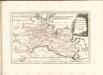

Theatrum belli in Pomerania citeriore
1 : 220000 Mollova mapová sbírka Berger
Mappa Ducatus Megalopolitani Nova :
1 : 190000 Mollova mapová sbírka
Karte von Neu-Vorpommern und der Insel Rügen
1 : 200000 Přední Pomořansko (Německo) Hagenow, Fr. von Hube, C. A. Fr. v. Hagenow
Rugiae, Usedomiae, Et Iulinae, Wandalicarum insularum vera descriptio. [Karte], in: Theatrum orbis terrarum, S. 121.
1 Karte aus Atlas Ortelius, Abraham
Rugiae, Usedomiae, Et Iulinae, Wandalicarum insularum Vera descriptio
Mollova mapová sbírka Ortelius, Abraham