Maps of Garz/Rügen

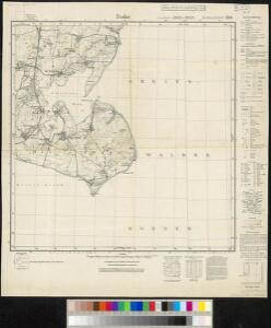
Meßtischblatt 1746 : Zudar, 1937
1 : 250000 Zudar. - Hrsg. 1886, bericht. 1925. - 1:25000. - [Berlin]: Reichsamt für Landesaufnahme, 1937. - 1 Kt.
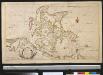
Rugia Insula Ac Ducatus
1 : 240000 Mollova mapová sbírka Lubin, Eilhard Covens, Johannes I
Rugia Insula Ac Ducatus
1 : 265000 Mollova mapová sbírka Lubin, Eilhard Schenk, Peter I
Rugia Insula Ac Ducatus
1 : 240000 Mollova mapová sbírka Lubin, Eilhard Blaeu, Joan I.
Rugia Insula Ac Ducatus
1 : 525000 Mollova mapová sbírka Merian, Matthäus Merian, Matthäus
Rugia Insula Ac Ducatus
1 : 265000 Mollova mapová sbírka Lubin, Eilhard Janssonius, Johannes I
Composite: 89. Greifswald. (Germany)
1 : 100000 Reichsamt fur Landesaufnahme
Composite: 64. Bergen a. Rugen. (Germany)
1 : 100000 Reichsamt fur Landesaufnahme
64. Bergen a. Rugen. (Germany)
1 : 100000 Reichsamt fur Landesaufnahme
Das Pommerische Kriegs Theatrum
1 : 200000 Mollova mapová sbírka Krügner, Johann Gottfried Boetius, Johann Theodor
Rvgia insvla ac dvcatvs
1 : 270000 Rujana (Německo) Lubin, Eilhard Janssonius, Johannes Ioannis Ianßonius
27. Greifswald, uit: Topographische Uebersichtskarte des Deutschen Reiches / herausgegeben v. d. Kartogr. Abt. d. Königl. Preuß. Landesaufnahme
1 : 200000 titelvariant: Topogr. Übersichtskarte des Deutschen Reiches; Annotatie: Titel boven bladen ook: Topogr. Übersichtskarte des Deutschen Reiches; Annotatie geografische gegevens: Op elk blad twee maatstokken: 10 Kilometer = 5,5 cm; 1 geogr. Meile = 3,6 cm; Legenda onder op elk blad Königlich Preußische Landesaufnahme. Kartographische Abtheilung [S.l : Königlich Preußische Landesaufnahme, Kartographische Abtheilung]
Rügen


Reise Karte von der Insel Rügen
Rujana (Německo) Hagenow, Friedrich von Janssonius, Johannes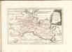


RVGIA | INSVLA AC DVCATVS
accuratissimè descripta ab E. Lubino. | Adjecta sunt ad utrumque latus Baronum et Nobilium | antiquissimarum familiarum in Insula Rugia habi- | tantium, juxta alphabeti ordinem, Insignia. Amsterdami | Apud Guiljelmum Blaeuw.
Insulae et principatus Rugiae cum vicinis Pomeraniae littoribus nova tabula
1 : 215000 Pomořansko (Německo a Polsko) Homann, Johann Baptist J. B. Homann
Insulae et principatus Rugiae cum vicinis Pomeraniae littoribus nova tabula
1 : 215000 Pomořansko (Německo a Polsko) Homann, Johann Baptist â Ioh. Baptista Homanno

Rugia Insula Ac Ducatus accuratissimè descripta [Karte], in: Novus Atlas, das ist, Weltbeschreibung, Bd. 1, S. 93.
1 Karte aus Atlas Blaeu, Joan Blaeu, Willem Janszoon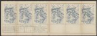
Rugia Insula Ac Ducatus accuratissimè descripta ab E. Lubino. [Karte], in: Le théâtre du monde, ou, Nouvel atlas contenant les chartes et descriptions de tous les païs de la terre, Bd. 1, S. 122.
1 Karte aus Atlas Blaeu, Willem Janszoon und Blaeu, Joan Blaeu, Willem Janszoon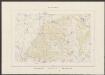
Rugia Insula Ac Ducatus accuratissimè descritpta [...] [Karte], in: Theatrum orbis terrarum, sive, Atlas novus, Bd. 1, S. 171.
1 Karte aus Atlas Blaeu, Joan Blaeu, Willem Janszoon
Rugia Insula Ac Ducatus accuratissime descripta [Karte], in: Novus atlas absolutissimus, Bd. 2, S. 48.
1 Karte aus Atlas Janssonius Offizin
Theatrum belli in Pomerania citeriore
1 : 220000 Mollova mapová sbírka Berger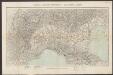
Nova Famigerabilis Insulae Ac Ducatus Rugiae Descriptio. [Karte], in: Gerardi Mercatoris et I. Hondii Newer Atlas, oder, Grosses Weltbuch, Bd. 1, S. 325.
1 Karte aus Atlas Mercator, Gerhard und Hondius, Jodocus Jansson, Jan
Insulae Et Principatus Rugiae cum vicinis Pomeraniae Littoribus Nova Tabula
1 : 210000 Mollova mapová sbírka Homann, Johann Baptista - dědici
Eigentliche Abbildung der Pomerischen Insul Rügen : Auf welcher die Dänen und Allűrte, von den Schweden auß Stralsund unversehens überfallen, eine gäntzliche Niederlag erlitten, und dadurch die ganze Insul den Schweden wieder raumen müssen. Geschehen Dienstag den 8. 18. Januarÿ Anno 1678
1 : 185000 Mollova mapová sbírka