Maps of Denmark
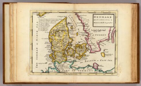
Denmark.
1 : 2700000 Moll, Herman, d. 1732
Daniae Regnum [Karte], in: Gerardi Mercatoris Atlas, sive, Cosmographicae meditationes de fabrica mundi et fabricati figura, S. 140.
1 Karte aus Atlas Mercator, Gerhard Montanus, Petrus
Royaume de Danemark
1 : 1740000 Dánsko Bonne, Rigobert André
Dania regnum in quo sunt ducatus Holsatia et Slesvicum insulae Danicae et provinciae Iutia Scania Blekingia et Hallandia
1 : 1100000 Dánsko Danckerts, Justus per I. Danckers
[Daenemark mit Holstein u. Lauenburg]
Stieler's Hand-Atlas Stieler, Adolf bei Justus Perthes
Le royaume de Danemark
1 : 1200000 Dánsko Sanson, Guillaume Cordier, Louis chez H. Iaillot
Dania Regnum [Karte], in: Theatrum orbis terrarum, sive, Atlas novus, Bd. 1, S. 47.
1 Karte aus Atlas Blaeu, Joan Blaeu, Willem Janszoon

Atlas für Handel und Industrie: Für Kaufleute, Fabrikante u. Gewerbetreibende, Handlungs- u. Gewerbe-Schulen

Regni Daniae accuratissima delineatio
1 : 1150000 Dánsko Wit, Frederick de Frederick de Witt
Dania Regnum [Karte], in: Novus Atlas, das ist, Weltbeschreibung, Bd. 1, S. 33.
1 Karte aus Atlas Blaeu, Joan Blaeu, Willem Janszoon
Danemarck.
1 : 1180000 Robert de Vaugondy, Gilles, 1688-1766
[Daenemark mit Holstein und Lauenburg; auch Island und Fär-Öer]
Schul-Atlas über alle Theile der Erde nach dem neuesten Zustande, und über das Weltgebäude Stieler, Adolf bei Justus Perthes

Daenemark mit Holstein und Lauenburg auch südlicher Theil von Schweden
1 : 3200000 Dánsko
Daniae Regnum [Karte], in: Atlas, sive, Cosmographicae meditationes de fabrica mundi et fabricati figura, S. 135.
1 Karte aus Atlas Mercator, Gerhard
Daniae Regnum [Karte], in: Gerardi Mercatoris et I. Hondii Newer Atlas, oder, Grosses Weltbuch, Bd. 1, S. 103.
1 Karte aus Atlas Mercator, Gerhard und Hondius, Jodocus Jansson, Jan
Daenemark
E. von Sydow's Schul-Atlas in sechs und dreissig Karten Sydow, Emil von bei Justus Perthes
Das Königreich Daenemark
1 : 1090000 Dánsko Weiland, Karl Ferdinand Geographischen Institut
Das Königreich Daenemark
1 : 1090000 Dánsko Weiland, Karl Ferdinand Maedel, A. Geograph. Institut
Regni Daniae
1 : 1129000 Dánsko Visscher, Nicolaus per Nicolaum Visscher
REGNI DANIAE, Novißima et accuratißima TABULA
1 : 1130000 Dánsko Visscher, Nicolaus per Nicolaum Visscher
Dania Regnum [Karte], in: Le théâtre du monde, ou, Nouvel atlas contenant les chartes et descriptions de tous les païs de la terre, Bd. 1, S. 49.
1 Karte aus Atlas Blaeu, Willem Janszoon und Blaeu, Joan Blaeu, Willem Janszoon
Daenemark mit Schleswig, Holstein und Lauenburg auch Südl. Theil v. Schweden
Hand-Atlas über alle Theile der Erde nach dem neuesten Zustande und über das Weltgebäude Stieler, Adolf bei Justus Perthes
Das Königreich Daenemark nebst seinen Nebenlaendern in Europa
1 : 1100000 entworfen und gezeichnet von C.F. Weiland Weimar : Verlag des Geographischen Instituts
Regni Daniae, Novißima et Accuratißima Tabula [Karte], in: Novus atlas absolutissimus, Bd. 1, S. 119.
1 Karte aus Atlas Janssonius Offizin
Daenemark
Allgemeiner Atlas [Walch, Johannes] im Verlag bei Johannes Walch
Regni Daniæ : novissima et accuratissima tabula / per Nicolaum Visscher
1 : 1150000 Annotatie: Origineel is Blad 144 in atlas factice; Annotatie geografische gegevens: Met schaalstok: Milliaria Germanica communia Nicolaes Jansz. Visscher jr. 1649-1702 [Amsterdam] : [Nicolaes Visscher]