Maps of Vanceburg

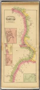
Upper Ohio River and Valley part XXI, 362 to 381 miles below Pittsburgh ... (with) Buena Vista, Rockville & Commercialtown, Rome, Ohio; Quincy, Ky.
1 : 31680 Hayes, Eli L.
Vanceburg
1 : 62500
Buena Vista
1 : 24000
Buena Vista
1 : 24000
Pond Run
1 : 24000
Pond Run
1 : 24000
Pond Run
1 : 24000
Buena Vista
1 : 24000
Pond Run
1 : 24000
Buena Vista
1 : 24000
Pond Run
1 : 24000
Vanceburg
1 : 24000
Garrison
1 : 24000
Vanceburg
1 : 24000
Vanceburg
1 : 24000
Vanceburg
1 : 24000
Vanceburg
1 : 24000
Garrison
1 : 24000
Garrison
1 : 24000
Garrison
1 : 24000
Garrison
1 : 24000
Garrison
1 : 24000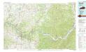
Maysville
1 : 100000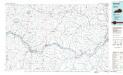
Maysville
1 : 100000
Concord
1 : 24000
Concord
1 : 24000
Charters
1 : 24000
Charters
1 : 24000
Charters
1 : 24000