Maps of Mediterranean Sea
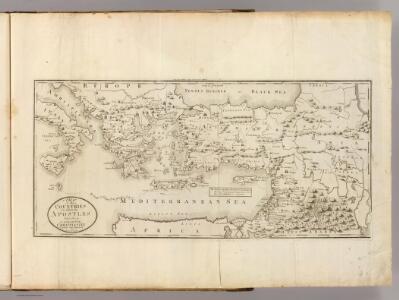
Countries ... Apostles Travelled: in propagating Christianity.
1 : 6000000 Carey, Mathew
Geographische beschryvinghe van de wandeling der apostelen ende de reysen Pauli, : mitsgaders de landen ende rijcken daer sij het Evangelium eerst hebben verkondight, / nieuwlijcx int licht gebracht door Nicolaes Visscher ; A. vanden Broeck sculp
1 : 7000000 Annotatie: Kaart van het oostelijk deel van de Middellandse Zee, omringd door 9 gravures van de reizen van Paulus; Rechtsonder genummerd: 6; Origineel is Blad 184 in atlas factice; Annotatie geografische gegevens: Met 2 schaalstokken Nicolaes Jansz Visscher sr 1618-1679; Abraham van den Broeck ca. 1616-1688 [Amsterdam : Nicolaas Visscher]
Východní Středomoří
Kuchař, Karel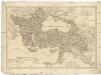
Europaeische und asiatische Türkey
1 : 3530000 Evropa jihovýchodní Mollo, Tranquillo T. Mollo
Di-gyiu Du, Ng Da-tsiu Di-du[地舆图、五大洲地图]
Di-gyiu Du, Ng Da-tsiu Di-du[地舆图、五大洲地图] 1853年,Martin, W. A. P. (William Alexander Parsons) 美国长老会传教士丁韪良用罗马拼音标注宁波方言编写的世界地理著作,对地球和各大洲进行介绍。内有东西半球图、亚洲图、欧洲图、非洲图、北美洲图、南美洲图、地中海附近图、清内地十八省图、浙江省图、宁波附近图等。 10图,墨刻本,罗马拼音标注宁波方言,图幅不一,约39 x 49.5 cm Harvard-Yenching | Rare Book | TA 2370 92,Hollis Number:008156153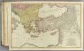
Mediterranean E.
1 : 2850000 Faden, William, 1750?-1836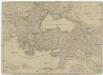
Europaeische und asiatische Türkey
1 : 7100000 Blízký východ Mollo, Tranquillo T. Mollo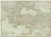
Europaeische und asiatische Türkey
1 : 7100000 Evropa jihovýchodní Mollo, Tranquillo Tranquillo Mollo
Europaeische und asiatische Türkey
1 : 4300000 Blízký východ Mollo, Tranquillo T. Mollo
Peregrinationis divi Paulitypus Corographicus
General Karte des Türkischen Reichs (in Europa und Asien)
1 : 6150000 Evropa jihovýchodní Artaria
General Karte des Türkischen Reichs (in Europa und Asien)
1 : 6150000 Asie západní Fried, Franz Artaria
General Karte des Türkischen Reichs in Europa und Asien
1 : 6150000 Asie západní Fried, Franz Artaria
Balkánské státy a Turecko
1 : 3000000 Bospor (Turecko : průliv) Paulík, Ant. Klus, František Ústřední učitelské nakladatelství a knihkupectví
L'Empire Grec à la mort de Basile le Bulgarochtone et sous ses Héritiers
Byzantinisches Reich Basileios II.
Tabula geographica ad acta aposto
Středozemní moře-oblast východní Berka, Jan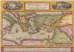
Peregrinationis Divi Pauli Typus Corographicus [...] [Karte], in: Theatrum orbis terrarum, S. 442.
1 Karte aus Atlas Ortelius, Abraham
Uebersichts Karte des russisch - türkischen Kriegsschauplatzes in Europa und Asien

The Turkish empire in Europe and Asia with the Kingdom of Greece
1 : 8400000 Blízký východ Walker, C. Society for the diffusion of useful knowledge
Das lateinische Kaiserthum in Constantinopel und die christlichen Reiche im Orient 1204
Lateinisches Kaiserreich , Kreuzfahrerstaaten
Europaeische und asiatische Türkey
1 : 4250000 Blízký východ Mollo, Tranquillo T. Mollo
A new map shewing all the severall countries, cities, towns and other places mentioned in the New Testament [1 - in Greece Cyprus, Asia and parts adjoining; 2 - in Italy, Mesopotamia &c.; 3 - in the Holy Land and parts adjoining.]
from A new sett of maps both of antient and present geography : wherein not only the latitude and longitude of many places are corrected according to the latest observations, but also the most remarkable differences of antient and present geography may be quickly discern'd by a bare inspection or comparing of correspondent maps, which seems to be the most natural and easy method to lead young students (for whose use the work is principally intended) unto a competent knowledge of the geographical science : together with a geographical treatise particularly adapted to the use and design of these maps / by Edward Wells, M.A. and student of Christ-Church, Oxon.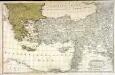
Dritter Theil der Karte von Europa welcher das südliche Russland Polen und Ungarn die europæische, und beinahe die ganze asiatische Türkei enthælt, 2
1 Blatt : 54 x 84 cm F.A. Schrämbl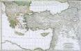
Troisième partie de la carte d'Europe contenant le midi de la Russie, la Pologne et la Hongrie, la Turquie y compris celle d'Asie presqu'entière, 2
1 Blatt : 53 x 84 cm chez l'auteur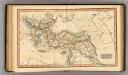
Ottoman Empire.
1 : 14100000 Fenner, Rest.
De landen van 't Romeinsche gebied in welke de Christen kerk, kort na Christus hemelvaard, door den dienst der apostelen is uitgebreid : tot verklaringe van de Handelingen der Apostelen
1 : 6500000 afgebeeld door W.A. Bachiene J. van Jagen mapp. sculpsit, et figur. apposit sculpturam curavit ; S. Fokke fecit. Uitgegeven te Gorinchem : by Nicolaas Goetzee
Die Türkey
Evropa jihovýchodní
Das Oströmische Reich zur Zeit Karls des Gr.
Byzantinisches Reich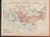
L'Empire Grec au Commencement du IX.e siècle
Byzantinisches Reich Kümmerly & Frey