Maps of Highland

Schottland.
1 : 1750000 Flemming, Carl
Ancient Britain II.
1 : 1830000 Society for the Diffusion of Useful Knowledge (Great Britain)
Scotia, Regnum. [Karte], in: Atlas, sive, Cosmographicae meditationes de fabrica mundi et fabricati figura, S. 83.
1 Karte aus Atlas Mercator, Gerhard
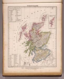
Scotland.
1 : 1950000 Mitchell, Samuel Augustus
Scotland.
1 : 1950000 Mitchell, Samuel Augustus
Nieuwe kaart van 't noorder gedeelte van Grootbritannie behelzelde het Koningryk Schotland
1 : 1750000 Annotatie: Uit: Nieuwe en beknopte hand-atlas ... - Amsterdam : Isaak Tirion, [na 1769] Amsterdam : Isaak Tirion

Scotland or N. Britain.
1 : 1500000 Bowen, Emanuel
[Schotland mit der Nördlichen Spitze von England]
Hand-Atlas über alle Theile der Erde nach dem neuesten Zustande und über das Weltgebäude Stieler, Adolf bei Justus Perthes
Exactissima Regni Scotiae tabula tam in septentrionalem et meridionalem quam in minores earundem provincias, insulasque ei undique praetensas accurate divisa
1 : 950000 per Nicolaum Visscher Amst. Bat. [Amsterdam] : nunc apud P. Schenk Junior
Scotland.
1 : 3000000 Seaman, James V.

Karte von Scotland
1 : 900000 Skotsko Dorret, J. Schraembl, Franz Anton F.A. Schraembl
Karte von Scotland
1 : 900000 Skotsko Dorret, J. Schraembl, Franz Anton F.A. Schraembl
Schotland
1 : 1380000 Shetlandy (Skotsko) bei Marco Berra
Scotland (with) inset map of the Shetland Islands.
1 : 2027520 Tallis, J. & F.
Scotland.
1 : 4000000 Fenner, Rest.
Scotland.
1 : 2250000 Carey, Mathew
Scotland.
1 : 2534400 Lucas, Fielding Jr.
Scotland.
1 : 2250000 Carey, Mathew
Scotia Regnum. [Karte], in: Gerardi Mercatoris Atlas, sive, Cosmographicae meditationes de fabrica mundi et fabricati figura, S. 100.
1 Karte aus Atlas Mercator, Gerhard Montanus, Petrus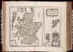
Scotia Regnvm cum insulis adjacentibus / Robertus Gordonius a Straloch descripsit
1 : 1400000 titelvariant: Scotia Regnvm; Annotatie: Met opdracht door Robertus Gordonius aan Jacobus Hamiltonius; Origineel is Blad 30 in atlas factice; Annotatie geografische gegevens: Met 2 schaalstokken Robert Gordon 1580-1661 [Amsterdam : Joan Blaeu]
Composite: Scotland.
1 : 486830 Stanford, Edward
A New and Correct Mercator Map of Northern Britain [or Scotland]
During the Jacobite Rising, the English forces, led by George II’s son, William, Duke of Cumberland pursued Bonnie Prince Charlie's army back across the Scottish border. They arrived at Edinburgh at the end of January 1746, and then ventured north to Aberdeen. The Jacobites fled further north, but Cumberland was in no mood to hurry after them. He was acutely aware of the difficulty of moving troops through the Highland terrain, where roads were few and opportunities for ambush many. The most up-to-date map of Scotland available to both the English and the Jacobite sides was this map by John Elphinstone, a military engineer who served with the Duke of Cumberland's army. Though it was drawn in 1745, and was a great improvement on earlier maps, it nonetheless attracted criticism for its inaccuracies. Elphinstone's depiction of hills, for example, is entirely schematic with none of the detail necessary to thread a route between Highland glens or plan military offensives. Cumberland realised his lack of local topographical knowledge would put the English at a serious disadvantage. He spent the next two months acquiring what information he could about the lie of the land and training his troops for the particular type of campaign they would be forced to fight. Elphinstone's map was engraved by Thomas Kitchen, who worked in London's Holborn, and published by Andrew Millar in the Strand. Copies of the map were sold for 1s 6d. This one has been coloured by hand to indicate the territories of the Highland clans. Elphinstone, John Kitchin, Thomas
Scotland ancient, modern.
1 : 2200000 Patteson, Edward
Scotland (outline)
1 : 2200000 Patteson, Edward
[Schotland mit der Nördlichen Spitze von England]
Hand-Atlas über alle Theile der Erde nach dem neuesten Zustande und über das Weltgebäude Stieler, Adolf bei Justus Perthes
Scotia antiqva
2 Karten auf 1 Blatt : Kupferdruck ; Bildgrösse 42 x 54 cm Blaeu; Gordon Joan Blaeu
Partie, l'Angleterre. Europe 7.
1 : 1641836 Vandermaelen, Philippe, 1795-1869