Maps of Highland

Scotland.
1 : 1950000 Mitchell, Samuel Augustus
Scotland.
1 : 1950000 Mitchell, Samuel Augustus
Ancient Britain II.
1 : 1830000 Society for the Diffusion of Useful Knowledge (Great Britain)
Schottland.
1 : 1750000 Flemming, Carl
Nieuwe kaart van 't noorder gedeelte van Grootbritannie behelzelde het Koningryk Schotland
1 : 1750000 Annotatie: Uit: Nieuwe en beknopte hand-atlas ... - Amsterdam : Isaak Tirion, [na 1769] Amsterdam : Isaak Tirion
Schotland
1 : 1380000 Shetlandy (Skotsko) bei Marco Berra
Neueste Karte von Schotland
Grosser Hand-Atlas über alle Theile der Erde in 170 Karten Meyer, J. Verlag des Bibliographischen Instituts
Scotia Regnvm cum insulis adjacentibus / Robertus Gordonius a Straloch descripsit
1 : 1400000 titelvariant: Scotia Regnvm; Annotatie: Met opdracht door Robertus Gordonius aan Jacobus Hamiltonius; Origineel is Blad 30 in atlas factice; Annotatie geografische gegevens: Met 2 schaalstokken Robert Gordon 1580-1661 [Amsterdam : Joan Blaeu]
Scotland.
1 : 1930000 Tanner, Henry S.
Scotia, Regnum. [Karte], in: Atlas, sive, Cosmographicae meditationes de fabrica mundi et fabricati figura, S. 83.
1 Karte aus Atlas Mercator, Gerhard
Scotland.
1 : 3000000 Seaman, James V.
[87][87] Scotia Regnum ..., uit: Atlas sive Descriptio terrarum orbis
Annotatie: Gedigitaliseerde versie. Amsterdam. Heiloo : Picturae (vervaardiger), 2015. tiff-bestand. Gedigitaliseerd: 07-01-2015; Origineel: Universiteitsbibliotheek Vrije Universiteit (XL.05127.-) ; Netherlands; Titelpagina ontbreekt Wit, Frederik de Amsterdam : Frederick de Wit
Exactissima Regni Scotiae tabula tam in septentrionalem et meridionalem quam in minores earundem provincias, insulasque ei undique praetensas accurate divisa
1 : 950000 per Nicolaum Visscher Amst. Bat. [Amsterdam] : nunc apud P. Schenk Junior
Composite: Scotland.
1 : 486830 Stanford, Edward
[Schotland mit der Nördlichen Spitze von England]
Hand-Atlas über alle Theile der Erde nach dem neuesten Zustande und über das Weltgebäude Stieler, Adolf bei Justus Perthes
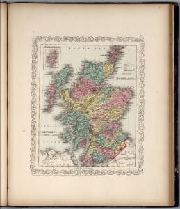
Scotland (with) inset map of the Shetland Islands.
1 : 2027520 Tallis, J. & F.
Scotland.
1 : 4000000 Fenner, Rest.
Scotland.
1 : 2250000 Carey, Mathew
Scotland.
1 : 2534400 Lucas, Fielding Jr.
Scotland.
1 : 2250000 Carey, Mathew
Scotland or N. Britain.
1 : 1500000 Bowen, Emanuel
Scotland.
1 : 1170000 Society for the Diffusion of Useful Knowledge (Great Britain)
Scotland.
1 : 1520640 Burr, David H., 1803-1875
Map of Scotland
1 : 700000
Airfields, UK
Great Britain. War Office. General Staff. Geographical Section
Scotia Regnum
1 : 1345000
A new and correct map of Scotland and the Isles, containing all ye cities, market towns, boroughs &c., the principal roads, with ye computed miles from town to town
1 : 2100000

SCOTIA | ANTIQVA, | qualis priscis temporibus, | Romanis præsertim, cognita suit | quam in lucem eruere conabatur | R. Gordonius a Straloch | MDCLIII
[Amsterdam : Joan Blaeu]