Maps of Crimea
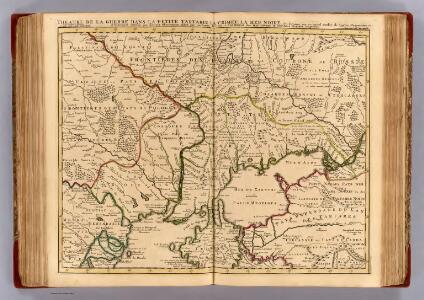
Theatre de la guerre, Petite Tartarie, Crimee, Mer Noire.
1 : 1250000 L'Isle, Guillaume de, 1675-1726
Nova Mappa Geographica TARTARIAE EUROPAEAE SEU MINORIS et in specie CRIMEAE ex NOVISSIMIS OBSERVATIONIBUS represendata
1 : 2050000 Krym (Ukrajina) Probst, Johann Michael Ioh. Michael Probst
Cimmeria, quae Postea Scythia Europaea Seu Parva Scythia / Ex Conatibus Geographicis Gulielmi Sanson
1 : 3000000 1 Karte : Kupferdruck ; 38 x 48 cm Sanson, Guillaume Apud I. Covens et C. Mortier
Die neurussischen Gouvernements 1775-1793
Ukraine (Süd), Neurussland, Verwaltungsgliederung Anton, J.
Karte der deutschen Siedlungen in Neu (Süd)-Rußland
Russland Russland

Théatre des opérations de la guerre dans la Tartarie du Cuban, Ozakow & Tartarie Crimée, avec les marches & rendés vous de l'armée de Russie contre les Turcs & Tartares, le tout suivant l'original de Pétersbourg, venant du camp de la Tartarie, Crimeé, mois de juillet [1]737
1 : 1680000 Ukrajina jižní Briffaut, E. chez le sieur Briffaut
Theatre des operations de la guerre dans la Tartarie du Cuban Ozakow & Tartarie Crimée, avec les marches & rendés vous de l'armée de Russie contre les Turcs & Tartares, le tout suivant l'original de Petersbourg, venant du camp de la Tartarie Crimeé mois de juillet [1]737
1 : 1680000 Ukrajina jižní Briffaut, E. chez le sieur Briffaut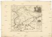
Carte generale des expeditions militaires des armées victorieuses de sa Maieste imperiale de toutes les Russies sur le Don et le Dnepr l'an 1736
1 : 1690000 Dněpr-oblast
Gouv. 15. Kostroma, 17. Nishegorod
1 : 2300000 1 Karte : Lithographie ; 26 x 19 cm Schlieben, W.E.A. von [Georg Joachim Göschen]
A map of the lesser Tartary / done from the original, published by the Imperial Academy of Sciences
1 : 1700000 1 Karte : Kupferdruck ; 39 x 45 cm Senex, John [Iohn Senex]
Charte der Kriegs Operationen am Donn u: Dnieper Ihro Russisch Kayserl. Maiestaet glorieusen Armeen
1 : 1700000 1 Karte : Kupferdruck ; 38 x 44 cm (ganzes Blatt 54 x 64 cm) Seutter, Matthäus zu haben bey Matthaeus Seutter der röm: kayserl: u: königl: cathol: Majest: Geogr
Gouv. 13. Wologda
1 : 3500000 1 Karte : Lithographie ; 19 x 26 cm Schlieben, W.E.A. von [Georg Joachim Göschen]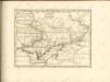

Theatrum belli Ao. MDCCXXXVII a milite Augustae Russorum Imperatricis adversus Turcas Tattarosque ge
1 : 1900000 1 Karte : Kupferdruck ; 46 x 65 cm apud R. & I. Ottens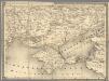
14. Cherson
1 : 1400000 Schubert, Friedrich Theodor
Theatrum belli a.o MDCCXXXVII & XXXVIII a milite augustae russorum imperatricis adversus Turcas Tatt
1 : 2000000 1 Karte : Kupferdruck ; 48 x 66 cm apud Joan Block
Gouv. 18. Tambow, 19. Riaesan
1 : 2300000 1 Karte : Lithographie ; 26 x 19 cm Schlieben, W.E.A. von [Georg Joachim Göschen]
Scythia Europaea Et Asiatica Cum Chersoneso Taurica Ante et Post Christum Natum ad Seculum V
1 : 6500000 Mollova mapová sbírka
Russia in Europe Part VIII with index map.
1 : 2250000 Society for the Diffusion of Useful Knowledge (Great Britain)
Gouv. 32. Das Land der Donischen Kosaken
1 : 2300000 1 Karte : Lithographie ; 26 x 23 cm Schlieben, W.E.A. von [Georg Joachim Göschen]
Kremlenagrad. Castellum urbis Moskvae
1 Karte : Kupferdruck ; 37 x 49 cm [Joan Blaeu]
Gouv. 16. Wladimir, 20. Tula
1 : 2300000 1 Karte : Lithographie ; 26 x 19 cm Schlieben, W.E.A. von [Georg Joachim Göschen]
Generalʹnaja karta Kavkazskago kraja / izdana pri Voennom sbornikė
1 : 1300000 1 Karte gefaltet : Lithografie ; 75 x 91 cm [Verlag nicht ermittelbar]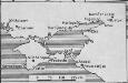
[Taurien]
Taurien (Gouvernement) Verwaltungsgliederung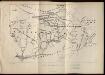
Obščij plan zaporožskich vladěnīj
Ukraine Saporoschje (Region) Saporoger Kosaken
Carte du gouvernement de Tauride comprenant la Krimée et les pays voisins
1 : 1150000 Krym (Ukrajina) par les freres Lotter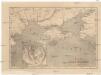
Bojiště černomořské
Krym (Ukrajina)