Maps of Balkan Pen.

Turkey, Hungary
1 : 10100000 Seaman, James V.
Tabula Europae IX. [Karte], in: Claud. Ptolemaeus. Geographia lat. cum mappis [...], S. 278.
1 Karte aus Atlas Münster, Sebastian [und Ptolemaeus, Claudius]

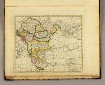
A General Map of Turky in Europe, Hungary etc
1 : 7000000 Mollova mapová sbírka Moll, Herman Moll, Hermann
Balkan Peninsula.
1 : 3220177 Stanford, Edward
Turkey
1 : 6437376 Shows the Balkan Peninsula Relief shown by landforms. Language: English Place of publication not identified : publisher not identified
Turky in Europe.
1 : 3900000 Bowen, Emanuel
Karte von dem Oschmanischen Reiche in Europa
1 : 2800000 Balkánský poloostrov Anville, Jean-Baptiste Bourguinon d' Marco Berra
Karte von dem Oschmanischen Reiche in Europa
1 : 2800000 Balkánský poloostrov Reilly, Franz Johann Josef von Anville, Jean-Baptiste Bourguinon d' Franz Ioh. Ios. von Reilly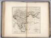
Turkey, in Europe and Hungary.
1 : 5800000 Carey, Mathew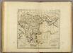
Turkey, in Europe and Hungary.
1 : 5900000 Carey, Mathew
Turkey, in Europe and Hungary.
1 : 5702400 Carey, Mathew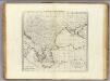
Turkey, in Europe and Hungary.
1 : 6336000 Carey, Mathew
Turkey, in Europe and Hungary.
1 : 6336000 Carey, Mathew
Bez titulu: soubor map pag. 265

Turkischen Reiche in Europa.
1 : 6500000 Haller von Hallerstein, Friedrich
Libération et agrandissements successifs des états Balkaniques
1 : 14000000 Balkanhalbinsel Südosteuropa Unabhängigkeitsbewegung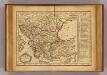
Turquie.
1 : 9300000 Delamarche, Charles Francois; Lattre, Jean
Griechenland und die Länder der Balkan-Halbinsel
Plastischer Schul-Atlas über alle Theile der Erde : in 24 Karten Woldermann, G Verlag von P. Eckerlein
Karte von dem Türkischen Reiche in Europa
Neuester Schul-Atlas Walch, Johann im Verlag bei Joh. Walch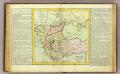
Turquie d'Europe.
1 : 6000000 Clouet, J. B. L. (Jean-Baptiste Louis), b. 1730
Homannův atlas světa
1 : 1900000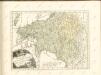
Regni Hungariae, Graeciae, et Moreae, ac regionum, quae ei quondam fuêre christiani, ut Transilvaniae, Valachiae, Moldaviae, Bessarabiae, Bosniae, Sclavoniae, Serviae, Bulgariae, Croatiae, Romaniae, Dalmatiae, Morlachiae, Ragusanae republicae, maximaeq partis Danubii fluminis novissima delineatio
1 : 4000000 1 Karte : Kupferdruck ; 49 x 57 cm Danckerts, Johannes [Danckerts]
Carte de la Turkie d'Europe
1 : 3600000 Evropa jihovýchodní Lapie, Pierre Arnoul Firmin Didot
Turkey in Europe.
1 : 3850000 Mitchell, Samuel Augustus
Turquie d'Europe, Grece.
1 : 3500000 Andriveau-Goujon, J.
La Turchia d'Europa
1 : 10000000 Evropa jihovýchodní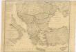
Karte von dem Osmanischen Reiche in Europa