Maps of Hoboken

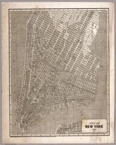
City of New York
1 : 29000 Breese, S.
The city of New York drawn from actual surveys as furnished by the several city surveyors
1 : 2350 [s.n.]
Plan of the city of New-York : the greater part from actual survey made expressly for the purpose (the rest from authentic documents) / by Thos. H. Poppleton, city surveyor ; P. Maverick sc. Newark.
from Manhattan
Plan von New-York
Grosser Hand-Atlas über alle Theile der Erde in 170 Karten Meyer, J. Verlag des Bibliographischen Instituts
Plan of the city of New-York : the greater part from actual survey made expressly for the purpose (the rest from authentic documents) / by Thos. H. Poppleton, city surveyor ; P. Maverick sc. Newark.
from Manhattan
Plan von der Stadt New-York.
from Manhattan
Plan of the city of New-York : with the recent and intended improvements / drawn from actual survey by William Bridges, city surveyor, A.D. 1807 ; engraved by Peter Maverick.
from Manhattan
City of New York, 1843.
from The cerographic atlas of the United States. By Sidney E. Morse, A.M., and Samuel Breese, A.M.
City of New-York.
1 : 17000 Mitchell, Samuel Augustus
Plan of the city of New-York : the greater part from actual survey made expressly for the purpose (the rest from authentic documents)
1 : 7300 Poppleton, Thomas H Prior & Dunning
Plan von der Stadt New York
1 : 68500 New York (New York)
Hooker's new pocket plan of the city of New York / compiled & surveyed by William Hooker, engraver, No. 179 Water Street, New York, house, Willoughby St., Brooklyn.
From Manhattan
Topographical Atlas Of The City Of New York
1 : 12000 Viele, Egbert L.
Plan of the city of New-York / drawn from actual survey by C[a]simir Th. [G]oerck, and Joseph Fr. Mangin, city surveyors.
from Manhattan
Key
From Atlas 107. Vol. 1, 1894.
A plan of the city and environs of New York : as they were in the years 1742-1743 and 1744 / drawn by D.G. in the 76th year of his age who had at this time a perfect & correct recollection of every part of the same.
from Manhattan
Plan of the city of New York, 1808
1 : 7500 Longworth, David, 1765?-1821 Common Council
A new & accurate plan of the city of New York in the state of New York in North America, published in 1797.
from Manhattan
Plan of the city of Brooklyn, L.I. / by William Perris.
from Brooklyn
Key
From Atlas 110. Vol. 2, 1903.
Plan of the city of New York
1 : 12500 Tiebout, Cornelius, 1777-1832 T. & J. Swords
To His Excellency Sr. Henry Moore, Bart., captain general and governour in chief in & over the province of New York & the territories depending thereon in America, chancellor & vice admiral of the same, this plan of the city of New York is most humbly inscribed
1 : 4800 Ratzer, Bernard s.n.
To His Excellency Sr. Henry Moore, Bart., captain general and governour in chief, in & over the Province of New York & the territories depending thereon in America, chancellor & vice admiral of the same, this plan of the city of New York, is
from Manhattan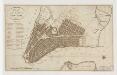
Plan of the city of New-York
1 : 12500 Tanner, Benjamin, 1775-1848 s.n.
To His Excellency Sr. Henry Moore, Bart., captain general and governour in chief in & over the province of New York & the territories depending thereon in America, chancellor & vice admiral of the same, this plan of the city of New York is mo
from Charts and maps
The city of New York / Will L. Taylor, chief draughtsman.
from Whole
12B - N.Y. City (Aerial Set).
from Sectional aerial maps of the City of New York / [photographed and assembled under the direction of the chief engineer, July 1st, 1924].
"Where all the Village meet to eat" - An accurate and detailed map of Greenwich Village and Environment.
From Manhattan
A view of Collect Pond and its vicinity in the City of New York in 1793 : on which pond the first boat propelled by steam with paddle wheels or screw propellers was constructed by John Fitch, six years before Robert Fulton ... / by John Hutchings.
from Manhattan