Maps of Queens County

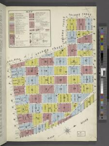
Key
From Atlas 110. Vol. 2, 1903.
Map showing the old high water lines along the shores of Brooklyn & New York together the the pier lines as established by law.
From Manhattan
New map of that part of the city of New York south from 20th Street on the Hudson & 35th Street on the East River : showing the position of Greenwich, Washington and West Streets on the Hudson River, and Pearl, Water, Front, Cherry & Tompkins Sts. on the
from Manhattan
12B - N.Y. City (Aerial Set).
from Sectional aerial maps of the City of New York / [photographed and assembled under the direction of the chief engineer, July 1st, 1924].
Plan von New-York
Grosser Hand-Atlas über alle Theile der Erde in 170 Karten Meyer, J. Verlag des Bibliographischen Instituts
Map of the city of New-York extending northward to Fiftieth St. / surveyed and drawn by John F. Harrison, C.E.
from Manhattan
City of New York
1 : 29000 Breese, S.
Plan of the city of Brooklyn, L.I. / by William Perris.
from Brooklyn
Part of the 23rd Ward, New York City.
from Atlas of the city of New York : from official records, private plans & actual surveys / compiled under the supervision of E. Robinson & R. H. Pidgeon.
"Where all the Village meet to eat" - An accurate and detailed map of Greenwich Village and Environment.
From Manhattan
Sheet 7: [Bounded by Mc Dougall Street, Houston Street, Hancock Street, Bleecker Street, Sixth Avenue, E, Twentieth Street,Avenue A, Delancy Parkway, Bowery and Spring Street.]
from Plan of New York City, from the Battery to Spuyten Duyvil Creek. Showing every lot and building thereon; old farm lines, strreet numbers at the corners of blocks, railroads, steamboat landings, bulkhead and pier lines, etc. Based on the surveys made by Messrs. Randall & Blackwell, and on the special survey by J. F. Harrison.
Map of the real estate in the city of New York : between the south side of Washington Parade, 4th St., and the north side of Bellevue, 28th Street / compiled from authentic documents by Edwin Smith, city surveyor, 1831 ; engd. by D.R. Harrison.
from Manhattan
Sheet 8: [Bounded by 20th Street, Delancy Slip, Tompkins Street, Rivington Street and Avenue A.]
from Plan of New York City, from the Battery to Spuyten Duyvil Creek. Showing every lot and building thereon; old farm lines, strreet numbers at the corners of blocks, railroads, steamboat landings, bulkhead and pier lines, etc. Based on the surveys made by Messrs. Randall & Blackwell, and on the special survey by J. F. Harrison.
Map showing the old farms : from 4th to 28th Street, east of 6th Avenue, New York / compiled from authentic documents by Edwin Smith, city surveyor, 1831.
from Manhattan
Map showing the old high water lines along the shores of Brooklyn & New York together the the pier lines as established by law.
From Manhattan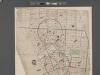
[Map of New York City between Canal and 22nd Sts?? and Broadway and the Hudson River School District No. 9, showing population and school attendance figures.]
From Manhattan
Part of Section 2 : Plate 26
from Atlas of the borough of Manhattan, city of New York.
Map showing the high and low water mark and the original city grants of lands under water made to various parties from 1686 to 1873, extending from Battery to Fifty-first Street, Hudson and East Rivers, New York City, also the several pier and bulkhead l
from Whole
Page 4: [Bounded by Luise Street (Kips Bay), East River, (Stuyvesant Square) E. Thirteenth Street, Third Avenue, Irving Place (Union Square) and Broadway.]
from Sackersdorf Farm Set.
Plate 12: Bounded by W. 27th Street, E. 27th Street, First Avenue, E. 26th Street, Avenue A, E. 14th Street, and Sixth Avenue.
from Atlas of the city of New York : embracing all territory within its corporate limits from official records, private plans & actual surveys / by and under the supervision of E. Robinson & R.H. Pidgeon, civil engineers.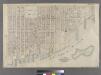
Part of Wards 11, 17 & 18, New York City.
from Atlas of the city of New York : embracing all territory within its corporate limits from official records, private plans & actual surveys / by and under the supervision of E. Robinson & R.H. Pidgeon, civil engineers.
Part of Ward 17, New York City.
from Atlas of the city of New York : embracing all territory within its corporate limits from official records, private plans & actual surveys / by and under the supervision of E. Robinson & R.H. Pidgeon, civil engineers.
Key
From Atlas 42.53. Vol. 3, 1895.
Sheet 10: [Bounded by E. Fortieth Street, First Avenue, E. Twentieth Street and Sixth Avenue.]
from Plan of New York City, from the Battery to Spuyten Duyvil Creek. Showing every lot and building thereon; old farm lines, strreet numbers at the corners of blocks, railroads, steamboat landings, bulkhead and pier lines, etc. Based on the surveys made by Messrs. Randall & Blackwell, and on the special survey by J. F. Harrison.
A plan of the city and environs of New York : as they were in the years 1742-1743 and 1744 / drawn by D.G. in the 76th year of his age who had at this time a perfect & correct recollection of every part of the same.
from Manhattan
Sheet 5:[Bounded by Morton Street, Washington Street, Leroy Street, Hudson Street, Clarkson Street, Varick Street, Houston Street, Bowery Street, Chatham Square, Chatham Street, Reade Street and Washington Street.]
from Plan of New York City, from the Battery to Spuyten Duyvil Creek. Showing every lot and building thereon; old farm lines, strreet numbers at the corners of blocks, railroads, steamboat landings, bulkhead and pier lines, etc. Based on the surveys made by Messrs. Randall & Blackwell, and on the special survey by J. F. Harrison.
Sheet 4: [Bounded by Bowery, Rivington Street, East Street,Grand Stret, Water Street, Corlears Street, (Pier Line) South Street, James Slip, James Street, Madison Street and Catherine Street.]
from Plan of New York City, from the Battery to Spuyten Duyvil Creek. Showing every lot and building thereon; old farm lines, strreet numbers at the corners of blocks, railroads, steamboat landings, bulkhead and pier lines, etc. Based on the surveys made by Messrs. Randall & Blackwell, and on the special survey by J. F. Harrison.
7. Wards 11, 18.
1 : 2400 G.W. Bromley & Co.; Geo. W. Bromley & E. Robinson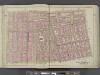
Manhattan, Double Page Plate No. 8 [Map bounded by W. 3rd St., E. 3rd St., Essex Ave., Broome St., S. 5th Ave.]
From Atlas of the city of New York, Manhattan Island. From actual surveys and official plans