Maps of Península Ibérica
Spain, Portugal.
1 : 1930000 Rand McNally and Company
Spain, Portugal, W. France.
1 : 3000000 Philip, George
Hispaniæ et Portvgaliæ regna
1 Karte : Kupferdruck ; 26 x 33 cm Weigel Christoph Weigel
L'Espagne
1 Karte : Kupferdruck ; 45 x 59 cm Coronelli; Guérard; Nolin; Du Tralage chez I. B. Nolin geographe ordinaire du roy
A new and accurate map of Spain and Portugal
1 Karte : Kupferdruck ; 34 x 42 cm Bowen s.n.
Die durch die Engellænder beunruhigte französische Küsten a.o 1758
1 Karte : Kupferdruck ; 47 x 49 cm, Bildgrösse 48 x 59 cm Heyden; Lotter; Lotter verlegt von Tobias Conrad Lotter
Regnorum Hispaniæ et Portugalliæ tabula generalis
1 Karte : Kupferdruck ; 47 x 55 cm Homann Johann Baptist Homann
Carte historique et geographique des royaumes d Espagne et de Portugal
1 Karte : Kupferdruck ; Bildgrösse 43 x 52 cm Châtelain s.n.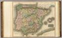
Spain, Portugal.
1 : 1950000 Thomson, John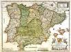
L'Espagne
1 Karte : Kupferdruck ; 38 x 51 cm Duval chez sa veuve sur le quay de l'orloge pres le palais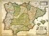
L'Espagne
1 Karte : Kupferdruck ; 38 x 51 cm Duval chez l'auteur proche du palais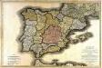
Carte routière des royaumes d'Espagne et de Portugal
1 Karte auf 2 Blatt : Kupferdruck ; 57 x 87 cm Jaillot; Longchamps; Basset; López; Basset chez Basset rue St. Jacques au coin de celle des Mathurins
Novissima et accuratissima tabula regnorum Hispaniæ et Portugalliæ
1 Karte : Kupferdruck ; 46 x 59 cm Allard ex officina I. Cóvens et C. Mortier
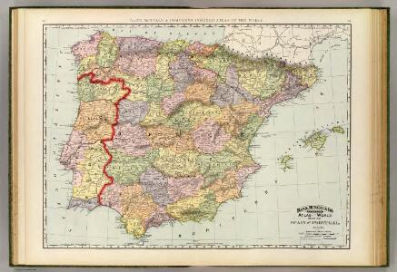
Spain and Portugal.
1 : 5000000 Bowen, Frances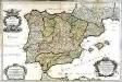
L'Espagne
1 Karte auf 2 Blatt : Kupferdruck ; 57 x 87 cm Sanson; Denis; Basset; Basset chés Basset rüe St. Jacques au coin de celle des Mathurins à l'image Ste. Genevieve
Spanien, Portugal.
1 : 3700000 Flemming, Carl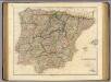
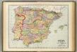
Spain, Portugal.
1 : 1900000 Arrowsmith, John
Weg-wyzer der legertogten in Spanje en Portugaal
1 Karte : Kupferdruck ; 49 x 57 cm Allard Abraham Allard
Accuratissima totius regni Hispaniæ Portugalliæ[que] tabula et typus novissimus
1 Karte : Kupferdruck ; 48 x 57 cm Wit ex officina Frederici de Witt
Novissima regnorum Hispaniæ et Portugalliæ tabula
1 Karte : Kupferdruck ; 48 x 56 cm Homann; Funck edita per Davidem Funcken
Hispaniae et Portugalliae regna [et]c
1 Karte : Kupferdruck ; 48 x 56 cm Homann; Funck ex officina Davidis Funckii
Hispaniæ et Portugalliæ regna
1 Karte : Kupferdruck ; 45 x 55 cm Visscher s.n.
Accuratissima totius regni Hispaniæ tabula
1 Karte : Kupferdruck ; 48 x 56 cm Danckerts ex officina Justi Danckerts
Accuratissima totius regni Hispaniae tabula
1 : 2400000 1 Karte : Kupferdruck ; 48 x 56 cm Danckerts, Justus [Danckerts]
Novissima et accuratissima regnorum Hispaniæ et Portugalliæ mappa geographica
1 Karte : Kupferdruck ; 48 x 56 cm Seutter; Probst anjezo in Verlag bey Ioh. Michael Probst chalcogr
Novissima et accuratissima regnorum Hispaniæ et Portugalliæ tabula
1 Karte : Kupferdruck ; 48 x 58 cm Wit ex officina I. Covens et C. Mortier
Novissima et accuratissima regnorum Hispaniæ et Portugalliæ tabula
1 Karte : Kupferdruck ; 48 x 58 cm Wit s.n.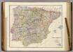
Spain & Portugal.
1 : 1900800 Arrowsmith, John
Theatre de la guerre en Espagne et en Portugal dressé sur les memoires des plus habiles ingenieurs
1 : 1200000 presenté à Philippe V, Roy d'Espagne, et des Indes [...] par [...] Jean Covens et Corneille Mortier, géographes A Amsterdam : Jean Cóvens et Corneille Mortier