Maps of Brooks Range

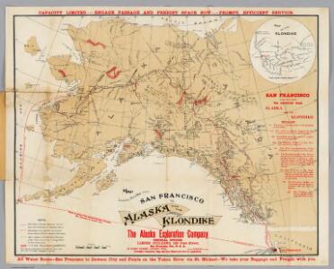
Map Showing Routes From San Francisco To Alaska And The Klondike.
1 : 4055000 Davidson, George
The Gold and Coal Fields of Alaska.
1 : 3600000 Geological Survey (U.S.)
Facsimile: Brue's North America (portion).
1 : 5600000 Brue, Adrien Hubert, 1786-1832
Facsimile: Petroof's Map of Alaska and Adjoining Regions.
1 : 4900000 Petroof, Ivan
Alaska.
1 : 7153000 Hammond, C.S.
Alaska.
1 : 7500000 Cram, George Franklin; Davis, Ellis Arthur
182-183. Alaska. The World Atlas.
1 : 5000000 USSR (Union of Soviet Socialist Republics).
Facsimile: Russian Dominions (portion).
1 : 6200000 Tichmenieff
Facsimile: Arrowsmith's America (northwestern portion).
1 : 7700000 Arrowsmith
Facsimile: Arrowsmith's North America (northwestern portion).
1 : 7050000 Arrowsmith
Facsimile: U.S. Coast Survey Northwestern America (portion).
1 : 5000000 U.S. Coast Survey
Facsimile: Arrowsmith's North America (portion).
1 : 4300000 Arrowsmith, Aaron
Facsimile: Canada (portion).
1 : 12400000 Johnston, J.
Nordamerika [Nebenkarte]
Nordamerika Alaska
Facsimile: Pacific Ocean. Cook River to Gulf of California. British Admiralty Chart (portion).
1 : 4840000 British Admiralty
Facsimile: Dawson's Canadian Map, 1887.
1 : 1900000 Dawson
Facsimile: U.S. Coast Survey Southeastern Alaska (portion).
1 : 2350000 U.S. Coast and Geodetic Survey
Facsimile: U.S. Coast Survey Southeastern Alaska (portion).
1 : 2350000 Emmons, G.T.
Facsimile: Southeastern Alaska with Four Boundary Lines.
1 : 2350000 U.S. Coast and Geodetic Survey
Chart of Part of the North West Coast of America.
1 : 2250000 La Perouse, Jean-Francois de Galaup, comte de, 1741-1788
Partie, l'Amerique Russe. Amer. Sep. 22.
1 : 1641836 Vandermaelen, Philippe, 1795-1869
Partie, l'Amerique Russe. Amer. Sep. 23.
1 : 1641836 Vandermaelen, Philippe, 1795-1869
Facsimile: Southeastern Alaska.
1 : 2350000 U.S. Coast and Geodetic Survey
Facsimile: Russian Map Numbered 5 (portion).
1 : 4925000 Alaskan Boundary Tribunal
Facsimile: Herbert's Colonial Manuscript Southern Alaska (portion).
1 : 3200000 Herbert, L., Senior
Facsimile: British Columbia and Northwest Territory (portion).
1 : 5100000 Edward Stanford
Facsimile: Portland Channel and Vicinity (portion).
1 : 175000 Scott, Robert N.
Sleem's Map Of Central Alaska.
1 : 625000 Sleem, D.H.
Composite: Sheets No. 1-24. Alaskan Boundary Tribunal. (Volume 3). Atlas of Award.
1 : 160000 Alaskan Boundary Tribunal