Maps of North Bergen

Map Of New York and Vicinity.
1 : 23000 Dripps, Matthew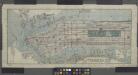
Title on face of map: Albemarle Hotel map of Manhattan, City of New York
from Manhattan
New York City south of 93rd Street.
From Manhattan
Colton's new map of the city and county of New York [North and South of 93rd St.] including the extension north of the Harlem River.
From Manhattan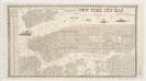
New York city map
Miller, James J. Miller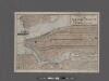
Elevated railway map of New York, Brooklyn, and Jersey City.
From Manhattan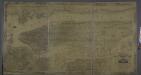
Topographical map of New York City, County and vicinity : showing old farm lines &c. / based on Randells and other official surveys, drawings and modern surveys by J.F. Harrison & T. Magrane ; printed by C. Wadlow.
from (A-Z)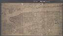
Topographical map of New York City, County and vicinity, showing old farm lines, etc. Based on Radell's and other official surveys, drawings and modern surveys.
From Manhattan
Map of the city and county of New York, showing routes and stations of the elevated railroads.
From Manhattan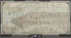
[Map of Manhattan from the Battery to 145th Street, showing adjacent portions of the Bronx, Long Island, and New Jersey]
from Manhattan
Outline and Index Map of Atlas of New York City : Manhattan Island.
from Atlas of the city of New York, Manhattan Island. From actual surveys and official plans / by George W. and Walter S. Bromley.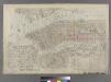
Outline & Index Map of New York City. Index I.
from Atlas of the city of New York : embracing all territory within its corporate limits from official records, private plans & actual surveys / by and under the supervision of E. Robinson & R.H. Pidgeon, civil engineers.
Aerial survey, Manhattan Island,New York City.
From Manhattan
Johnson's Map of NYC.
From Manhattan
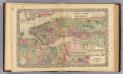
City and County Of New - York.
1 : 15840 Colton, J. H.
New York and vicinity
1 : 42240 Breese, Samuel
[New York City elevated Railroads.]
From Manhattan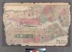
Plates 11 & 12: Map of New York City and central portion of Brooklyn.
from County atlas of Westchester, New York. Published by J.B. Beers & Co., assisted by S.W. Wilson and others.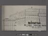
Manhattan, 1910 census tabulation tracts.
From Manhattan
Citizens and Travelers' Guide map in, to, and from the City of New York and adjacent places.
From Manhattan
Plan of New York and Brooklyn.
Beers, Frederick W.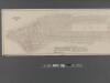
Fire Chart of the Borough of Manhattan, N.Y.
From Manhattan
Map of the cities of New York, Jersey City, Hoboken, with part of Brooklyn.
From Manhattan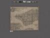
Map of the City of New York with the adjacent cities of Brooklyn & Jersey City, & the village of Williamsburg.
From Manhattan
Taunton's pocket edition of the merchant's and shipper's guide map to the port of New York / S.D.L. Taunton.
from Whole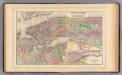
New York, Brooklyn.
1 : 29000 Mitchell, Samuel Augustus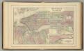
New York, Brooklyn.
1 : 29000 Mitchell, Samuel Augustus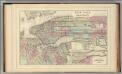
New York, Brooklyn.
1 : 29000 Mitchell, Samuel Augustus Jr.
New York, Brooklyn.
1 : 29000 Mitchell, Samuel Augustus