Maps of Appalachian Mountains

(Vereinigte Staaten von NordAmer)ika, nebst Mexico und Centralamerika (Ost)
1 : 7000000 Stein, Christ. Gottfr. Dan.
United States.
1 : 1500000 Smith, J. Calvin
A Correct Map of the United States.
1 : 4850000 Lewis, Samuel
Regni Mexicani seu Novæ Hispaniæ, Ludovicianæ, N. Angliæ, Carolinæ, Virginiæ, et Pensylvaniæ, nec non insvlarvm archipelagi Mexicani in America septentrionali accurata tabula
1 Karte : Kupferdruck ; 46 x 55 cm Homann Johann Baptist Homann
North America...S.E. Sheet.
1 : 7500000 Tanner, Henry S.
North America...S.E. Sheet.
1 : 7500000 Tanner, Henry S.

REGNI MEXICANI seu NOVAE HISPANIAE, LUDOVICIANAE, N. ANGLIAE, CAROLINAE, VIRGINIAE et PENSYLVANIAE nec non INSVLARVM ARCHIPELAGI MEXICANI IN AMERICA SEPTENTRIONALI accurata Tabula
1 : 9900000 Jižní Karolína Homann, Johann Baptist a Ioh. Baptista Homanno
Mappa geographica regionem Mexicanam et Floridam
1 : 11560000 Antily (souostroví) Lotter, Tobias Conrad [sumptibus] Tobiae Conradi Lotteri
Mappa geographica regionem Mexicanam et Floridam
1 : 11560000 Antily (souostroví) Seutter, Matthäus Lotter, Tobias Conrad sumptibus Mathaei Seutteri
REGNI MEXICANI seu NOVAE HISPANIAE, LUDOVICIANAE, N. ANGLIAE, CAROLINAE, VIRGINIAE et PENSYLVANIAE
1 : 11110000 Antily (souostroví) Bellin, Jacques-Nicolas â Ioh. Baptista Homanno
Map of the United States of North America / compiled from the latest and most authentic information by David H. Vance ; engraved by J.H. Young.
from Whole
North America, S.E. Sheet.
1 : 7600000 Tanner, Henry S.
Regni Mexicani seu Novae Hispaniae, Ludovicianae, N. Angliae, Carolinae, Virginiae, Pensylvaniae, necnon insvlarvm archipelagi Mexicani in America Septentrionali / accurata tabula exhibita a Ioh. Baptista Homanno.
from Parts John Baptista Homann, S.,
Regni Mexicani seu Novae Hispaniae, Ludovicianae, N. Angliae, Carolinae, Virginiae, Pensylvaniae, necnon insularum archipelagi Mexicani in America Septentrionali / accurata tabula exhibita à Ioh. Baptista Homanno.
from Charts and maps John Baptista Homann, S.,
Pascaarte vande vaste cust en eylanden van Westindien, als mede de Virginis en Nieu-Nederland, van C. Droge tot C. Cod
1 : 2705000
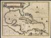
Indiarum occidentalium tractus littorales cum insulis Caribicis
1 Karte : Kupferdruck ; 49 x 56 cm Renard gedruckt by L. Renard
Mappa geographica regionem Mexicanam et Floridam terrasque adjacentes, ut et anteriores Americae insulas, cursus itidem et reditus navigantium versus flumen Missisipi et alias colonias ob oculos ponens
1 : 9300000 cura et sumptibus Tobiae Conradi Lotteri, Geographi Et Chalcographi Tob. Con. Lotter sculps. Augustae Vindel : [Tobias Conrad Lotter]
Depths and temperatures observed in the western part of the North Atlantic Ocean
1 : 7000000 United States Coast Survey U.S. Coast Survey
Carte des Etats-Unis

Pascaerte vande caribische eylanden
1 Karte : Kupferdruck ; 44 x 53 cm Doncker by Hendrick Doncker inde Nieubrugh steegh int Stuurmans gereeschap
Wyld's Military Map Of The United States.
1 : 4500000 Wyld, James, 1812-1887
Paskaert vande Cæribes Eylanden als mede vande vaste kust van caep Charles tot rio Gronoque en de bocht van Mexcico [Karte], in: De Nieuwe Groote Vermeerderde Zee-Atlas ofte Water-Werelt, S. 61.
1 Karte aus Atlas Doncker, Hendrick
Facsimile: British Empire in America by Popple.
1 : 18000000 Popple, Henry
Map of the United States and Canada : shewing Captn. Hall's route through those countries in 1827 & 1828 / engraved on steel by W.H. Lizars.
from Parts
Östliches Nordamerica
Neuer Handatlas über alle Theile der Erde Kiepert, Heinrich Verlag von Dietrich Reimer
United States.
from Whole
Amerique Septentrionale 4.
1 : 7500000 Brue, Adrien Hubert, 1786-1832
[144][147] Indiarum Occidentalium Tractus Littorales cum Insulis Caribicis ..., uit: Atlas sive Descriptio terrarum orbis
Annotatie: Gedigitaliseerde versie. Amsterdam. Heiloo : Picturae (vervaardiger), 2015. tiff-bestand. Gedigitaliseerd: 07-01-2015; Origineel: Universiteitsbibliotheek Vrije Universiteit (XL.05127.-) ; Netherlands; Titelpagina ontbreekt Wit, Frederik de Amsterdam : Frederick de Wit