Maps of West Indies

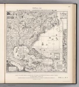
Facsimile: British Empire in America by Popple.
1 : 18000000 Popple, Henry
Mappa geographica regionem Mexicanam et Floridam
1 : 11560000 Antily (souostroví) Lotter, Tobias Conrad [sumptibus] Tobiae Conradi Lotteri
Mappa geographica regionem Mexicanam et Floridam
1 : 11560000 Antily (souostroví) Seutter, Matthäus Lotter, Tobias Conrad sumptibus Mathaei Seutteri
[144][147] Indiarum Occidentalium Tractus Littorales cum Insulis Caribicis ..., uit: Atlas sive Descriptio terrarum orbis
Annotatie: Gedigitaliseerde versie. Amsterdam. Heiloo : Picturae (vervaardiger), 2015. tiff-bestand. Gedigitaliseerd: 07-01-2015; Origineel: Universiteitsbibliotheek Vrije Universiteit (XL.05127.-) ; Netherlands; Titelpagina ontbreekt Wit, Frederik de Amsterdam : Frederick de Wit
A map of the West-Indies &c. with the adjacent countries: also ye trade winds, and ye several tracts made by ye galeons and flota from place to place / by H. Moll, g., 1727.; A set of thirty-two new and correct maps of the principal parts of Europe, &c.: with the great or post-roads, and principal cross-roads, done in the year 1725, 1726 and 1727: all except four, viz. England, Scotland, Ireland, and a general map of Turky in Europe, which have been done and printed before ... / all done according to the latest observations, by Herman Moll, geographer.
from A set of thirty-two new and correct maps of the principal parts of Europe, &c. : with the great or post-roads, and principal cross-roads, done in the year 1725, 1726 and 1727 : all except four, viz. England, Scotland, Ireland, and a general map of Turky in Europe, which have been done and printed before ... / all done according to the latest observations, by Herman Moll, geographer. Moll, Herman,
A map of the West-Indies &c. Mexico or New Spain, also ye trade winds, and ye several tracts made by ye galeons and flota from place to place
1 : 18000000
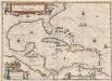
Pascaerte vande caribische eylanden
1 Karte : Kupferdruck ; 44 x 53 cm Doncker by Hendrick Doncker inde Nieubrugh steegh int Stuurmans gereeschap
REGNI MEXICANI seu NOVAE HISPANIAE, LUDOVICIANAE, N. ANGLIAE, CAROLINAE, VIRGINIAE et PENSYLVANIAE nec non INSVLARVM ARCHIPELAGI MEXICANI IN AMERICA SEPTENTRIONALI accurata Tabula
1 : 9900000 Jižní Karolína Homann, Johann Baptist a Ioh. Baptista Homanno
REGNI MEXICANI seu NOVAE HISPANIAE, LUDOVICIANAE, N. ANGLIAE, CAROLINAE, VIRGINIAE et PENSYLVANIAE
1 : 11110000 Antily (souostroví) Bellin, Jacques-Nicolas â Ioh. Baptista Homanno
Mappa geographica regionem Mexicanam et Floridam terrasque adjacentes, ut et anteriores Americae insulas, cursus itidem et reditus navigantium versus flumen Missisipi et alias colonias ob oculos ponens
1 : 9300000 cura et sumptibus Tobiae Conradi Lotteri, Geographi Et Chalcographi Tob. Con. Lotter sculps. Augustae Vindel : [Tobias Conrad Lotter]
Pascaarte vande vaste cust en eylanden van Westindien, als mede de Virginis en Nieu-Nederland, van C. Droge tot C. Cod
1 : 2705000
Carte du Mexique et de la Floride des Terres Angloises et des Isles Antilles du cours et des environs de la riviere de Mississipi
1 : 9000000 dressée sur un grand nombre de memoires principalement sur ceux de Mrs. d'Iberville et le Sueur par Guillaume De l'Isle geographe de l'Academie Royale des Sciences I. Stemmers Senior sculp. A Amsterdam : chez Jean Covens & Corneille Mortier
Insulae Americanae in Oceano Septentrionali, cum terris adiacentibus
1 : 1
Regni Mexicani seu Novæ Hispaniæ, Ludovicianæ, N. Angliæ, Carolinæ, Virginiæ, et Pensylvaniæ, nec non insvlarvm archipelagi Mexicani in America septentrionali accurata tabula
1 Karte : Kupferdruck ; 46 x 55 cm Homann Johann Baptist Homann
Paskaert vande Cæribes Eylanden als mede vande vaste kust van caep Charles tot rio Gronoque en de bocht van Mexcico [Karte], in: De Nieuwe Groote Vermeerderde Zee-Atlas ofte Water-Werelt, S. 61.
1 Karte aus Atlas Doncker, Hendrick
West Indies.
1 : 12500000 Bowen, Emanuel
Insulae Americanae In Oceano Septentrionali, cum Terris Adiacentibus. [Karte], in: Le théâtre du monde, ou, Nouvel atlas contenant les chartes et descriptions de tous les païs de la terre, Bd. 2, S. 308.
1 Karte aus Atlas Blaeu, Willem Janszoon und Blaeu, Joan Blaeu, Willem Janszoon

Indiarum occidentalium tractus littorales cum insulis Caribicis
1 Karte : Kupferdruck ; 49 x 56 cm Renard gedruckt by L. Renard
Insulae Americanae In Oceano Septentrionali, cum Terris adiacentibus. [Karte], in: Gerardi Mercatoris et I. Hondii Newer Atlas, oder, Grosses Weltbuch, Bd. 2, S. 379.
1 Karte aus Atlas Mercator, Gerhard und Hondius, Jodocus Jansson, Jan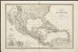
Carte du Méxique, des Antilles, d'une partie des Etats-Unis, et des pays circonvoisins
1 : 8333000 dressée d'après les nouvelles divisions, et les dernières observations par A. H. Dufour [gravée par] Guyot ; [écrite par] A. Pelicier Paris : Guyot [etc.]
Carte du Mexique et de la Floride, des terres angloises et des Isles Antilles, du cours et des environs de la riviere de Mississipi / dressée sur un grand nombre de memoires principalement sur ceux de Mrs. d'Iberville et le sueur, par Guillaume De l'Isle, geographe de l'Academie Royale des Sciences; I. Stemmers senior sculp.
from Mexico Guillaume de l'Isle; I. Stemmers,
Insulae Americanae In Oceano Septentrionali, cum Terris adiacentibus. [Karte], in: Theatrum orbis terrarum, sive, Atlas novus, Bd. 2, S. 312.
1 Karte aus Atlas Blaeu, Joan Blaeu, Willem Janszoon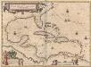
Insulae Americanae In Oceano Septentrionali, cum Terris adiacentibus. [Karte], in: Novus Atlas, das ist, Weltbeschreibung, Bd. 2, S. 311.
1 Karte aus Atlas Blaeu, Joan Blaeu, Willem Janszoon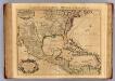
Mexique, Floride, Terres Angloises, Isles Antilles.
1 : 9000000 L'Isle, Guillaume de, 1675-1726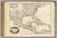
Mexique, Floride, Terres Angloises, Isles Antilles.
1 : 9000000 L'Isle, Guillaume de, 1675-1726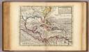
Map of the West-Indies, Mexico or New Spain.
1 : 21000000 Moll, Herman, d. 1732
Regni Mexicani seu Novae Hispaniae, Ludovicianae, N. Angliae, Carolinae, Virginiae, Pensylvaniae, necnon insvlarvm archipelagi Mexicani in America Septentrionali / accurata tabula exhibita a Ioh. Baptista Homanno.
from Parts John Baptista Homann, S.,