Maps of Andalucía
Portugal, Algarve meridionale.
1 : 1220000 Rizzi Zannoni, Giovanni Antonio Bartolomeo, 1736-1814
Een gedeelte van de Middelanse Zee van Gibraltar tot Ivica
Spain Gerard van Keulen
De Middellandsche Zee van Gibralter tot Algiers
Spain Gerard van Keulen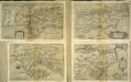
Andalvsia
1 Karte : Kupferdruck ; 15 x 25 cm Lambert Andreae
Le royaume de Murcie, partie des royaumes de Valence, de Castille Nouvelle, de Grenade [et]c. et l'isle d'Yviça
1 Karte : Kupferdruck ; 44 x 56 cm Jaillot; Dezauche; Cordier chez Dezauche successeur des S.rs De l'Isle et Buache rue des Noyers pres celle des Anglois


Espagne et Portugal. Flle. S.E.
1 : 1250000 Vivien St Martin, L.
Spain. Espana III.
1 : 1800000 Society for the Diffusion of Useful Knowledge (Great Britain)
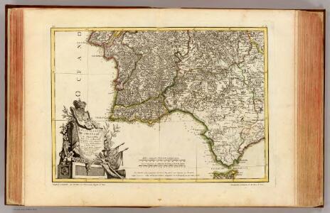
Regnum Castellæ novæ, Andalusiæ, Granadæ, et Algarbiæ, nec non maxime partis Portugalliæ, et Extremaduræ
1 Karte : Kupferdruck ; 45 x 55 cm Danckerts Justus Danckerts
Spain, South coast form Gibraltar to Alicante, and north coast of Barbary to cape Ferrat, from Spanish authorities, with corrections by Capt. W.H.Smyth. The north coast of Africa is from French surveys of 1833-55.
Walker, J. & C.
Granatae regnv[m]
1 Karte : Kupferdruck ; 15 x 23 cm Lambert Andreae
[Spanien und Portugal in 4 Blättern]
Hand-Atlas über alle Theile der Erde nach dem neuesten Zustande und über das Weltgebäude Stieler, Adolf bei Justus Perthes
Theatre de la guerre en Espagne et en Portugal, 4
1 Blatt : 51 x 63 cm Covens et Mortier
[Spanien und Portugal in 4 Blättern]
Hand-Atlas über alle Theile der Erde und über das Weltgebäude Stieler, Adolf Justus Perthes
Andaluziae Nova Descript. [Karte], in: Gerardi Mercatoris Atlas, sive, Cosmographicae meditationes de fabrica mundi et fabricati figura, S. 186.
1 Karte aus Atlas Mercator, Gerhard Montanus, Petrus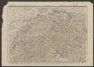
Andaluziae Nova Descript. [Karte], in: Gerardi Mercatoris et I. Hondii Newer Atlas, oder, Grosses Weltbuch, Bd. 1, S. 247.
1 Karte aus Atlas Mercator, Gerhard und Hondius, Jodocus Jansson, Jan
Espagne et Portugal. Flle. S.O.
1 : 1250000 Vivien St Martin, L.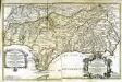
Parte meridional de las costas d'Españas
1 Karte auf 2 Blättern : Kupferdruck ; 53 x 82 cm López; Nolin; Guérard; Julien en casa de Thomas Lopez pensionista de s. m. c.a, chez le s.r Julien a l'hotel de Soubise
Perfectissima geographica delineatio regnorum Vandalitiæ, Granatæ, et Algarbiæ
1 Karte : Kupferdruck ; 47 x 58 cm Ottens; Ottens R. et J. Ottens
Regna Hispaniarum, atque Portugalliæ, 4
1 Blatt : 53 x 64 cm Gerard Valck
[Spanien und Portugal in 4 Blättern, Blatt 3]
Handatlas über alle Theile der Erde und über das Weltgebäude Stieler, Adolf Justus Perthes
Perfectissima geographica delineatio Regnorum Vandalitiae, Granatae, et Algarbiae; tractuum, Meridionalium Portugalliae Extremadurae ac Castellae Novae
1 : 1100000 summâ diligentià correcta et edita a R. & I. Ottens Amst. Batavo. Amst. R. & I. Ottens
A new Military Map of Spain and Portugal compiled from The Nautical Surveys of Don Vincent Tofiño, the new Provincial maps of Don Tomas Lopez, the large map of the Ptrenees by Roussill, and various original documents
1 Mapa en 4 seccions dins d'un estoig. John Stockdale J. Stockdale
Spain, Portugal 3.
1 : 1774080 Letts, Son & Co.

[Spanien und Portugal, Blatt 4]
Adolf Stieler's Handatlas über alle Theile der Erde und über das Weltgebäude Stieler, Adolf Justus Perthes
Spanien Und Portugal In 4 Blattern. Blatt 3.
1 : 1500000 Vogel, C.
Spanische Halbinsel, Blatt 4.
1 : 1500000 Vogel, C.