Maps of Andalucía

Perfectissima geographica delineatio Regnorum Vandalitiae, Granatae, et Algarbiae; tractuum, Meridionalium Portugalliae Extremadurae ac Castellae Novae
1 : 1100000 summâ diligentià correcta et edita a R. & I. Ottens Amst. Batavo. Amst. R. & I. Ottens
Perfectissima geographica delineatio regnorum Vandalitiæ, Granatæ, et Algarbiæ
1 Karte : Kupferdruck ; 47 x 58 cm Ottens; Ottens R. et J. Ottens
A new Military Map of Spain and Portugal compiled from The Nautical Surveys of Don Vincent Tofiño, the new Provincial maps of Don Tomas Lopez, the large map of the Ptrenees by Roussill, and various original documents
1 Mapa en 4 seccions dins d'un estoig. John Stockdale J. Stockdale
Regnum Castellæ novæ, Andalusiæ, Granadæ, et Algarbiæ, nec non maxime partis Portugalliæ, et Extremaduræ
1 Karte : Kupferdruck ; 45 x 55 cm Danckerts Justus Danckerts
Carte nouvelle de la partie meridionale du royaume de Portugal et des Algarves
1 Blatt : 46 x 59 cm Covens et Mortier
Spanien, Portugal SW.
1 : 1800000 Berghaus, Heinrich; Flemming, Carl; Sohr, Karl; Theinert, A.

Regna Hispaniarum, atque Portugalliæ, 3
1 Blatt : 53 x 63 cm Gerard Valck
[Spanien und Portugal, Blatt 3]
Adolf Stieler's Handatlas über alle Theile der Erde und über das Weltgebäude Stieler, Adolf Justus Perthes
Spanien Und Portugal In 4 Blattern. Blatt 3.
1 : 1500000 Vogel, C.
[Spanien und Portugal in 4 Blättern, Blatt 3]
Handatlas über alle Theile der Erde und über das Weltgebäude Stieler, Adolf Justus Perthes
Regnorum Castellæ novæ Andalusiæ Granadæ Valentiæ et Murciæ accurata tabula
1 Karte auf 2 Blatt : Kupferdruck ; 52 x 81 cm Visscher Nicolaes Visscher
[Spanien und Portugal in 4 Blättern]
Hand-Atlas über alle Theile der Erde und über das Weltgebäude Stieler, Adolf Justus Perthes
Espagne et Portugal. Flle. S.O.
1 : 1250000 Vivien St Martin, L.
[Spanien und Portugal in 4 Blättern]
Hand-Atlas über alle Theile der Erde nach dem neuesten Zustande und über das Weltgebäude Stieler, Adolf bei Justus Perthes
Les frontieres d'Espagne et de Portugal
1 Karte : Kupferdruck ; 57 x 42 cm Fer; Starckman chez l'auteur dans l'isle du Palais sur le quay de l'orloge a la sphere royale
Partie meridionale du royaume de Portugal, partie des royaumes de Castille nouvelle, de Andalousie et de Grenade
1 Karte : Kupferdruck ; 44 x 56 cm Jaillot; Dezauche chez Dezauche successeur des Sieurs Del'Isle et Buache 1.ers geographes du roi rue des Noyers près celle des Anglois
Andalvsia
1 Karte : Kupferdruck ; 15 x 25 cm Lambert Andreae
Mapa dos reynos de Portugal e Algarve
1 Karte : Kupferdruck ; 58 x 41 cm Lattré; Rizzi-Zannoni; Marillier; Berthault en casa de M. Lattré
Spanien west.
1 : 2350000 Radefeld, Carl Christian Franz, 1788-1874
El reyno de Portugal subdividido en muchas provincias
1 Karte : Kupferdruck ; 67 x 50 cm Longchamps en casa del autor, en casa del Barthelmy
Karte von den Königreichen Portugal und Algarbien
1 Karte : Kupferdruck ; 48 x 33 cm Sotzmann; López; Ramberg; Rizzi-Zannoni; Büsching; Jefferys s.n.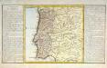
Le royaume de Portugal
1 Karte : Kupferdruck ; 30 x 31 cm, Bildgrösse 32 x 55 cm Clouet Mondhare
Andaluziae Nova Descript. [Karte], in: Gerardi Mercatoris Atlas, sive, Cosmographicae meditationes de fabrica mundi et fabricati figura, S. 186.
1 Karte aus Atlas Mercator, Gerhard Montanus, Petrus
Portugal, Algarve.
1 : 1250000 Robert Laurie & James Whittle
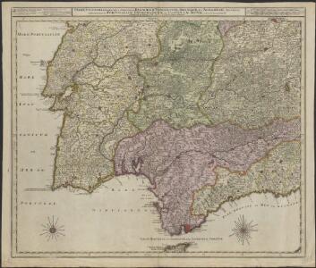
Portugalliae et Algarbiae regna
1 : 1740000 Algarve (Portugalsko) Seutter, Matthäus cura et studio Matthaei Seutteri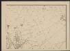
Andaluziae Nova Descript. [Karte], in: Gerardi Mercatoris et I. Hondii Newer Atlas, oder, Grosses Weltbuch, Bd. 2, S. 204.
1 Karte aus Atlas Mercator, Gerhard und Hondius, Jodocus Jansson, Jan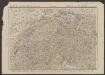
Andaluziae Nova Descript. [Karte], in: Gerardi Mercatoris et I. Hondii Newer Atlas, oder, Grosses Weltbuch, Bd. 1, S. 247.
1 Karte aus Atlas Mercator, Gerhard und Hondius, Jodocus Jansson, Jan