Maps of Fairfield County

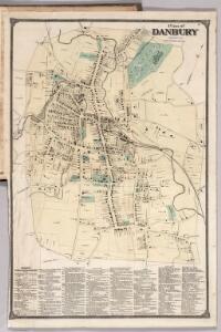
Plan of Danbury, Fairfield County, Connecticut.
1 : 4950 Beers, Frederick W.
Plan (Town) of Danbury, Fairfield County, Connecticut.
1 : 4950 Beers, Frederick W.
Danbury
1 : 24000
Danbury
1 : 24000
Danbury
1 : 24000
Danbury
1 : 24000
Danbury
1 : 24000
Danbury
1 : 31680
Danbury
1 : 62500
24. Danbury sheet.
1 : 62500 Geological Survey (U.S.)
Danbury
1 : 62500
Danbury
1 : 62500
Danbury
1 : 62500
Danbury
1 : 62500
Danbury
1 : 62500
Danbury
1 : 62500
Danbury
1 : 62500
Danbury
1 : 62500
Danbury
1 : 62500
Danbury
1 : 62500
Danbury
1 : 62500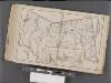
Westchester, Double Page Plate No. 31 [Map of Town of Poundridge, Lewisbord and North Salem] / prepared under the direction of Joseph R. Bien, from general surveys and official records.
From Atlas of Westchester County, New York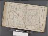
Westchester, Double Page Plate No. 30 [Map of Town of Bedford and Somers] / prepared under the direction of Joseph R. Bien, from general surveys and official records.
From Atlas of Westchester County, New York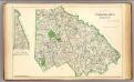
Fairfield Co. N.
1 : 72000 D.H. Hurd & Co.
Map of Dutchess County New York
from New illustrated atlas of Dutchess County, New York. / Compiled & drawn from personal examinations, surveys etc. under the personal supervision of O.W. Gray & Son and F.A. Davis, and published under the superintendence of H. L. Kochersperger.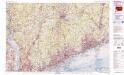
Bridgeport
1 : 100000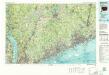
Bridgeport
1 : 100000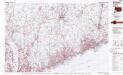
Bridgeport
1 : 100000
Cortlandt Manor map : prepared expressly for this work / copied for Piere Van Cortlandt esqr., June 1774, by G. Baneker.
from Cities and towns, A-Z