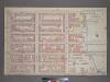
Maps of Queens County

13. Ward 21.
1 : 2400 G.W. Bromley & Co.; Geo. W. Bromley & E. Robinson
[Plate 13: Bounded by W. 40th Street, E. 40th Street, First Avenue (Harlem River, Lumber Yards), E. 27th Street, W. 27th Street and Sixth Avenue.]
from Atlas of the city of New York : embracing all territory within its corporate limits from official records, private plans & actual surveys / by and under the supervision of E. Robinson & R.H. Pidgeon, civil engineers.
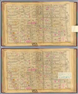
Manhattan, Double Page Plate No. 17 [Map bounded by E. 36th St., Lexington Ave., W. 25th St., 8th Ave.]
From Atlas of the city of New York, Manhattan Island. From actual surveys and official plans
[Plate 17: Bounded by W. 36th Street, E. 26th Street, Lexington Avenue, E. 25th Street, Madison Avenue, E. 26th Street, and Eighth Avenue.]
from Atlas of the city of New York, borough of Manhattan. From actual surveys and official plans / by George W. and Walter S. Bromley.
Plate 17: Bounded by W. 36th Street, E. 36th Street, Lexington Avenue, E. 25th Street, Madison Avenue, E. 26th Street, Fifth Avenue, W. 25th Street and Eighth Avenue.
from Atlas of the city of New York, Manhattan Island. From actual surveys and official plans / by George W. and Walter S. Bromley.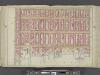
Manhattan, Double Page Plate No. 16 [Map bounded by Lexington Ave., E. 40th St., East River, E. 25th St.]
From Atlas of the city of New York, Manhattan Island. From actual surveys and official plans
[Plate 16: Bounded by Lexington Avenue, E. 40th Street, First Avenue [East River], and E. 25th Street.]
from Atlas of the city of New York, borough of Manhattan. From actual surveys and official plans / by George W. and Walter S. Bromley.
Part of Section 3 : New York City.
from Atlas of the city of New York, Manhattan Island. From actual surveys and official plans / by George W. and Walter S. Bromley.
Pl. 17: wards 16, 18, 20-21.
1 : 1800 Bromley, George Washington; Bromley, Walter Scott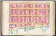
Pl. 16: wards 18, 21.
1 : 1800 Bromley, George Washington; Bromley, Walter Scott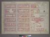
Plate 12, Part of Section 3: [Bounded by E. 32nd Street, First Avenue, E. 26th Street and Second Avenue.]
from Atlas of the city of New York, borough of Manhattan. From actual surveys and official plans / by George W. and Walter S. Bromley.
[Plate 61: Bounded by E. 37th Street, Third Avenue, E. 32nd Street, and Fifth Avenue.]
from Atlas of the borough of Manhattan, city of New York.
Part of Section 3 : Plate 56.
from Atlas of the borough of Manhattan, city of New York.
Part of Section 3 : Plate 55.
from Atlas of the borough of Manhattan, city of New York.
Part of Section 3 : Plate 62
from Atlas of the borough of Manhattan, city of New York.
[Plate 49: Bounded by W. 26th Street, Broadway (Madison Square), W. 20th Street, and Seventh Avenue.]
from Atlas of the borough of Manhattan, city of New York.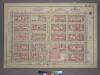
Plate 22, Part of Section 3: [Bounded by (E. 37th Street, Third Avenue, E. 32nd Street and Fifth Avenue.]
from Atlas of the city of New York, borough of Manhattan. From actual surveys and official plans / by George W. and Walter S. Bromley.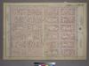
Plate 13, Part of Section 3: [Bounded by E. 32nd Street, Third Avenue, E. 26th Street and Fifth Avenue.]
from Atlas of the city of New York, borough of Manhattan. From actual surveys and official plans / by George W. and Walter S. Bromley.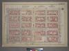
Plate 22, Part of Section 3: [Bounded by E. 37th Street, Third Avenue, E. 32nd Street and Fifth Avenue.]
from Atlas of the city of New York, borough of Manhattan. From actual surveys and official plans / by George W. and Walter S. Bromley.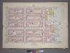
Plate 23, Part of Section 3: [Bounded by E. 37th Street, (East River Piers) First Avenue, E. 32nd Street and Third Avenue.]
from Atlas of the city of New York, borough of Manhattan. From actual surveys and official plans / by George W. and Walter S. Bromley.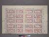
Plate 22, Part of Section 3: [Bounded by (E. 37th Street, Third Avenue, E. 32nd Street and Fifth Avenue.]
from Atlas of the city of New York, borough of Manhattan. From actual surveys and official plans / by George W. and Walter S. Bromley.
Plate 13, Part of Section 3: [Bounded by E. 32nd Street, Third Avenue, E. 26th Street and Fifth Avenue.]
from Atlas of the city of New York, borough of Manhattan. From actual surveys and official plans / by George W. and Walter S. Bromley.
Plate 14, Part of Section 3: [Bounded by W. 32nd Street, Fifth Avenue, W. 26th Street and Seventh Avenue.]
from Atlas of the city of New York, borough of Manhattan. From actual surveys and official plans / by George W. and Walter S. Bromley.
Plate 14, Part of Section 3: [Bounded by W. 32nd Street, Fifth Avenue, W. 26th Street, and Seventh Avenue.]
from Atlas of the city of New York, borough of Manhattan. From actual surveys and official plans / by George W. and Walter S. Bromley.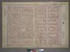
Plate 13, Part of Section 3: [Bounded by E. 32nd Street, Third Avenue, E. 26th Street, and Fifth Avenue.]
from Atlas of the city of New York, borough of Manhattan. From actual surveys and official plans / by George W. and Walter S. Bromley.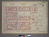
Plate 23, Part of Section 3: [Bounded by (E. 37th Street, (East River Piers) First Avenue, E. 32nd Street and Third Avenue.]
from Atlas of the city of New York, borough of Manhattan. From actual surveys and official plans / by George W. and Walter S. Bromley.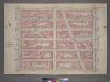
Plate 14, Part of Section 3: [Bounded by W. 32nd Street, Fifth Avenue, W. 26th Street and Seventh Avenue.]
from Atlas of the city of New York, borough of Manhattan. From actual surveys and official plans / by George W. and Walter S. Bromley.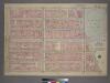
Plate 9, Part of Section 3: [Bounded by W. 26th Street, E. 26th Street, Madison Avenue, W. 23rd Street, Broadway, E. 20th Street, W. 20th Street and Seventh Avenue.]
from Atlas of the city of New York, borough of Manhattan. From actual surveys and official plans / by George W. and Walter S. Bromley.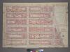
Plate 9, Part of Section 3: [Bounded by W. 26th Street, E. 26th Street, Madison Avenue, W. 23rd Street, Broadway, E. 20th Street, W. 20th Street and Seventh Avenue.]
from Atlas of the city of New York, borough of Manhattan. From actual surveys and official plans / by George W. and Walter S. Bromley.