Maps of Queens County

[Plate 61: Bounded by E. 37th Street, Third Avenue, E. 32nd Street, and Fifth Avenue.]
from Atlas of the borough of Manhattan, city of New York.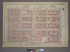
Plate 22, Part of Section 3: [Bounded by (E. 37th Street, Third Avenue, E. 32nd Street and Fifth Avenue.]
from Atlas of the city of New York, borough of Manhattan. From actual surveys and official plans / by George W. and Walter S. Bromley.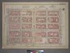
Plate 22, Part of Section 3: [Bounded by E. 37th Street, Third Avenue, E. 32nd Street and Fifth Avenue.]
from Atlas of the city of New York, borough of Manhattan. From actual surveys and official plans / by George W. and Walter S. Bromley.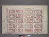
Plate 22, Part of Section 3: [Bounded by (E. 37th Street, Third Avenue, E. 32nd Street and Fifth Avenue.]
from Atlas of the city of New York, borough of Manhattan. From actual surveys and official plans / by George W. and Walter S. Bromley.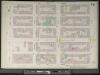
Manhattan, V. 4, Double Page Plate No. 74 [Map bounded by E. 37th St., 2nd Ave., E. 32nd St., 4th Ave.]
From Atlas 42.54. Vol. 4, 1890.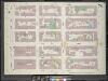
Manhattan, V. 4, Double Page Plate No. 74 [Map bounded by East 37th St., 2nd Ave., East 32nd St., Park Ave.]
From Atlas 113. Vol. 4, 1899.
[Plate 82: Map bounded by East 37th Street, Second Avenue, East 32nd Street, Fourth Avenue.]
from Maps of the city of New York / surveyed under directions of insurance companies of said city.
Manhattan, V. 4, Double Page Plate No. 75 [Map bounded by W. 37th St., E. 37th St., 4th Ave., E. 32nd St., W. 32nd St., 6th Ave.]
From Atlas 42.54. Vol. 4, 1890.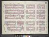
Manhattan, V. 4, Double Page Plate No. 75 [Map bounded by West 37th St., 4th Ave., East 32nd St., West 32nd St., Broadway, 6th Ave.]
From Atlas 113. Vol. 4, 1899.
Plate 74: Map bounded by East 37th Street, Second Avenue, East 32nd Street, Fourth Avenue
from Maps of the city of New York.
Plate 75: Map bounded by West 37th Street, East 37th Street, Fourth Avenue, East 32nd Street, West 32nd Street, Sixth Avenue
from Maps of the city of New York.
[Plate 83: Map bounded by West 37th Street, East 37th Street, Fourth Avenue, East 32nd Street, West 32nd Street, Sixth Avenue.]
from Maps of the city of New York / surveyed under directions of insurance companies of said city.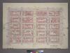
Plate 25, Part of Sections 3&5: [Bounded by E. 42nd Street, Third Avenue, E. 37th Street and Fifth Avenue.]
from Atlas of the city of New York, borough of Manhattan. From actual surveys and official plans / by George W. and Walter S. Bromley.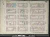
Manhattan, V. 4, Double Page Plate No. 77 [Map bounded by E. 42nd St., 2nd Ave., E. 37th St., Park Ave.]
From Atlas 42.54. Vol. 4, 1890.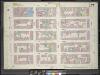
Manhattan, V. 4, Double Page Plate No. 77 [Map bounded by East 42nd St., 2nd Ave., East 37th St., Park Ave.]
From Atlas 113. Vol. 4, 1899.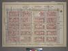
Plate 25, Part of Sections 3&5: [Bounded by E. 42nd Street, Third Avenue, E. 37th Street and Fifth Avenue.]
from Atlas of the city of New York, borough of Manhattan. From actual surveys and official plans / by George W. and Walter S. Bromley.
Plate 77: Map bounded by East 42nd Street, Second Avenue, East 37th Street, Fourth Avenue
from Maps of the city of New York.
[Plate 85: Map bounded by East 42nd Street, Second Avenue, East 37th Street, Fourth Avenue.]
from Maps of the city of New York / surveyed under directions of insurance companies of said city.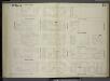
[Plate 79: Map bounded by East 32nd Street, Second Avenue, East 27th Street, Fourth Avenue.]
from Maps of the city of New York / surveyed under directions of insurance companies of said city.
Sale of 30 valuable building lots on & near the 5th Avenue in the 18th ward, by Anty. J. Bleecker, on Tuesday 8th May 1849 at 12 o'clock, at the Merchants' Exchange : [New York City].
from Manhattan
13. Ward 21.
1 : 2400 G.W. Bromley & Co.; Geo. W. Bromley & E. Robinson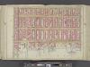
Manhattan, Double Page Plate No. 16 [Map bounded by Lexington Ave., E. 40th St., East River, E. 25th St.]
From Atlas of the city of New York, Manhattan Island. From actual surveys and official plans
[Plate 16: Bounded by Lexington Avenue, E. 40th Street, First Avenue [East River], and E. 25th Street.]
from Atlas of the city of New York, borough of Manhattan. From actual surveys and official plans / by George W. and Walter S. Bromley.
Part of Section 3 : New York City.
from Atlas of the city of New York, Manhattan Island. From actual surveys and official plans / by George W. and Walter S. Bromley.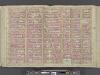
Manhattan, Double Page Plate No. 17 [Map bounded by E. 36th St., Lexington Ave., W. 25th St., 8th Ave.]
From Atlas of the city of New York, Manhattan Island. From actual surveys and official plans
[Plate 17: Bounded by W. 36th Street, E. 26th Street, Lexington Avenue, E. 25th Street, Madison Avenue, E. 26th Street, and Eighth Avenue.]
from Atlas of the city of New York, borough of Manhattan. From actual surveys and official plans / by George W. and Walter S. Bromley.
Plate 17: Bounded by W. 36th Street, E. 36th Street, Lexington Avenue, E. 25th Street, Madison Avenue, E. 26th Street, Fifth Avenue, W. 25th Street and Eighth Avenue.
from Atlas of the city of New York, Manhattan Island. From actual surveys and official plans / by George W. and Walter S. Bromley.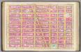
Pl. 17: wards 16, 18, 20-21.
1 : 1800 Bromley, George Washington; Bromley, Walter Scott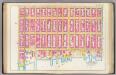
Pl. 16: wards 18, 21.
1 : 1800 Bromley, George Washington; Bromley, Walter Scott
![[Plate 61: Bounded by E. 37th Street, Third Avenue, E. 32nd Street, and Fifth Avenue.]](https://images-2.georeferencer.com/images/iiif/761910007337/full/,300/0/native.jpg)

