Maps of Laâyoune - Boujdour - Sakia El Hamra

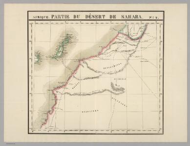
Partie, Desert de Sahara. Afrique 6.
1 : 1641836 Vandermaelen, Philippe, 1795-1869
Canary Ids.
1 : 2073600 Lucas, Fielding Jr.
Maroc (500 000 e). Oued Noun
1 : 500000 France. Service géographique de l'armée Service géographique de l'Armée
[Islas Canarias - Segunda Hoja]
1 : 280000 Coello, Francisco [Verlag nicht ermittelbar]
Carta de la Isla de Fuerteventura en las Canarias levantada en 1835 por el Teniente Arlett de la Marina R. Inglesa
Arlett Dirección de Hidrografia (Espanya)
De Noord Oosthoek van Grood Carnarien 1710
Canary Islands Gerard van Keulen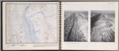
Horizontal Strata. Cuestas. Rich Tazigzaout, Morocco.
1 : 50000 O'Brien, Emmett J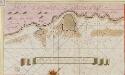
De tijhavens van Porto Cavallos en Porto de Naos 1710
Canary Islands Gerard van Keulen
Mapa militar isla de Gran Canaria
1 : 1000000 Gran Canaria (Kanárské ostrovy : ostrov) Depósito de la Guerra
Carta de la Isla de Gran Canaria
Arlett
Le Sahara Occidental d'après trois pèlerins de l'Adrar
1 : 1754385 Masqueray, Émile 1843-1894 Alger : imp. A. Jourdan
Iles Canaries et Madere. Afrique 5.
1 : 1641836 Vandermaelen, Philippe, 1795-1869
A chart of the Maderas and Canary Islands.
1 : 1770000 Jefferys, Thomas
INSULÆ | CANARIÆ, | Alias | FORTUNATÆ | dictæ.
[Amsterdam : Joan Blaeu]
247. Atlantic Ocean Islands. The World Atlas.
1 : 2500000 USSR (Union of Soviet Socialist Republics).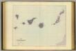
Canary Islands.
1 : 792000 Stanford, Edward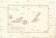
Isles Canaries
1 : 1720000 Kanárské ostrovy Bonne, Rigobert André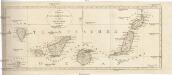
Neue CHARTE der CANARIEN INSELN
Kanárské ostrovy Bory de Saint-Vincent, Jean-Baptist Genevieve Marcellin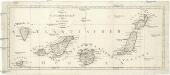
Neue Charte der Canarien Inseln
Kanárské ostrovy Bory de Saint-Vincent, Jean-Baptist Genevieve Marcellin
Carte générale du Maroc à l'échelle de 1 : 500 000 e. Agadir
1 : 500000 Maroc. Service géographique Rabat : Service géographique du Maroc
Karte von Fes und Marócos
Fez (Maroko) Canzler, Friedrich Gottlieb Haest in der Weigel- und Schneiderschen Handlung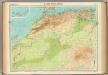
North-west Africa.
1 : 5000000 John Bartholomew and Son
Karte von der westlichen kuste von Africa : von der strasse bey Gibraltar bis zu dem XI grade norderbreite ...wahrnehmungen entworfen
1 : 1
A chart of the western coast of Africa, from the Straits of Gibraltar to eleven degrees of north latitude, including the Canary & Cape Verd Islands
1 : 13000000
Partie occidentale de l'Afrique
1 : 9600000 Afrika západní Bonne, Rigobert André
Spezial-Karte von Afrika
1 : 4000000 Blatt 1 Habenicht, Hermann Perthes
Barbariae et Guineae maritimi à freto Gibraltar ad fluvium Gambiae cum Insulis Salfis Flandrisis et Canaricis
1 : 55000000
De cust van Barbaria, Gualata, Arguyn en Geneheo van Capo S Vincente tot Capo Verde
1 : 6000000
Barbariæ et Guineæ maritimi à freto Gibraltar ad fluvium Gambiæ
1 Karte : Kupferdruck ; 47 x 56 cm Renard apud L. Renard