Maps of Argenteuil
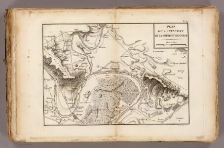
La Seine, l'Oise.
1 : 57000 Vincent
Flle. 2. Poissy, uit: Carte topographique des environs de Versailles dite "Carte des chasses du Roi"
1 : 28800 titelvariant: Carte des chasses du Roi; Annotatie: Herdruk van originele koperplaten; Oorspr. uitg.: 1764-1807; Voor aanwezige bladen zie overzichtsblad; Annotatie geografische gegevens: Opname: 1764-1773 [Paris : IGN]
Nord-Ouest: Paris Et Ses Environs.
1 : 40000 Service Geologique Des Mines (France)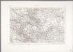
Paris
1 : 80000 Annotatie: Herdruk van originele koperplaat; Oorspr. uitg.: [Paris] : Dépôt de la Guerre, 1832 [Paris : IGN]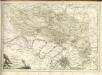
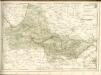

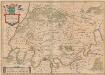
Carte dv pays et forest d'Yveline
1 Karte : Kupferdruck ; 39 x 49 cm Valck; Schenk apud G. Valk et P. Schenk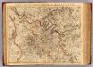
Paris, Prevoste, Vicomte.
1 : 180000 L'Isle, Guillaume de, 1675-1726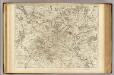
Paris, Prevoste et Vicomte de.
1 : 195000 L'Isle, Guillaume de, 1675-1726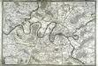
Les environs de Paris
1 Karte : Kupferdruck ; 50 x 73 cm Desnos chez Desnos géographe et ingénieur pour les globes spheres et instruments de mathematiques rue St. Jacques a l'enseigne du globe
Carte dv pays Vexin francois
1 : 140500 Valk, Gerhard Schenk, Pieter G. Valk et P. Schenk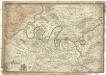
Les environs de Paris
1 : 101000 Paříž-oblast (Francie) Fer, Nicolas de Liébaux de Fer
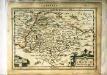
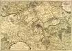
AGER PARISIENSIS | Vulgo | L'ISLE DE FRANCE
Fr. Guilloterius Bitur. Viu. describ. | et Cl. V. Petro Pithoeo I.C. | dedicabat Apud Guiljelmum Blaeu
Ager Parisiensis Vulgo L'Isle De France [Karte], in: Theatrum orbis terrarum, sive, Atlas novus, Bd. 2, S. 19.
1 Karte aus Atlas Blaeu, Joan Blaeu, Willem Janszoon
Ager Parisiensis Vulgo L'Isle De France [...] [Karte], in: Le théâtre du monde, ou, Nouvel atlas contenant les chartes et descriptions de tous les païs de la terre, Bd. 2, S. 45.
1 Karte aus Atlas Blaeu, Willem Janszoon und Blaeu, Joan Blaeu, Willem Janszoon
Ager Parisiensis Vulgo L'Isle De France [Karte], in: Novus Atlas, das ist, Weltbeschreibung, Bd. 2, S. 45.
1 Karte aus Atlas Blaeu, Joan Blaeu, Willem Janszoon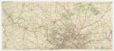
[Michelin 94], uit: Environs de Paris : carte des curiosités et des routes pittoresques
1 : 100000 Paris : Services du Tourisme Michelin
Carte cycliste et automobile des Environs de Paris
Carte nouvelle des environs de Paris contenant aussy la Brie
1 Karte : Kupferdruck ; 49 x 71 cm Crépy chez Crepy rue St. Jacques près la rue de la parcheminerie a St. Pierre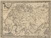
L'Isle de France. Parisiensis Agri Descrip. [Karte], in: Theatrum orbis terrarum, S. 126.
1 Karte aus Atlas Ortelius, Abraham Vrients, Jan Baptista
Ager Parisiensis Vulgo L'Isle De France [Karte], in: Novus atlas absolutissimus, Bd. 4, S. 94.
1 Karte aus Atlas Janssonius Offizin
CARTE | DV PAYS et FOREST | D'YVELINE, | que quelques uns mettent pour la partie Septentrionale | DE L'HUREPOIS
[Amsterdam : Joan Blaeu]
CARTE DV PAYS | VEXIN FRANÇOIS
Amstelodami, Apud Ioannem Blaeu

Ager Parisiensis Vulgo L'Isle De France [Karte], in: Gerardi Mercatoris et I. Hondii Newer Atlas, oder, Grosses Weltbuch, Bd. 2, S. 59.
1 Karte aus Atlas Mercator, Gerhard und Hondius, Jodocus Jansson, Jan
L'Isle de France. Parisiensis Agri Descriptio. [Karte], in: Gerardi Mercatoris Atlas, sive, Cosmographicae meditationes de fabrica mundi et fabricati figura, S. 235.
1 Karte aus Atlas Mercator, Gerhard Montanus, Petrus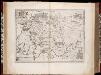
Ager Parisiensis vulgo l'Isle de France / Fr. Guilloterius ... describ. et Petro Pithoeo dedicabat
1 : 150000 Annotatie: Oorspr. verschenen in: Novus atlas ... - Amsterdami : apud Guiljelmum Blaeu, 1635; Origineel is Blad 15 in atlas factice Guilloterius, Fr.; Pithou, Pierre [Amsterdam : apud Guiljelmum Blaeu]
Nouvelle carte routiere des environs de Paris