Maps of Carpathian Mountains

Hungary, Transylvania, Croatia.
1 : 1500000 Cary, John, ca. 1754-1835
Hongrie. Coal Resources of the World.
1 : 1724100 de Pann, Charles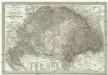
General - Post- und Strassen- Karte des Königreichs Ungarn und des Grossfürstenthums Siebenbürgen
1 : 1400000 Maďarsko Fried, Franz List, Joseph Artaria
M. Moraviae Pars per Hvnniam Occidentalem extensa
1 : 3100000 Mollova mapová sbírka
Tabula generalis regni Hungariae, Croatiae et Slavoniae nec non magni principatus Tranylvaniae
1 : 1400000 Chorvatsko Lipský, Ján Festetis, Georgio
Tabula generalis regni Hungariae, Croatiae et Slavoniae, nec non magni principatus Transylvaniae
1 : 1400000 Chorvatsko Lipský, Ján Festetis de Tolna, Georgio
Hungary, Transylvania.
1 : 4000000 Bowen, Frances
Das Königr. Ungarn mit seinen Nebenländern
Maďarsko Benecke Bormann, E. Ignaz Fuchs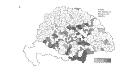
Die Bezirke der Tendenz "C" vor 1875
Ungarn Wahlbezirk, Wahlverhalten
Die Bezirke der Tendenz "C" nach 1875
Ungarn Wahlbezirk, Wahlverhalten
Allgemeine Postkarte von Ungarn Kroatien, Sklavonien und Siebenbürgen zur Uebersicht
Chorvatsko Benedict, Anton im von Reillyschen Landkarten und Kunstwerke Verschleiss Komptoir
Hvngaria Hodierni Temporis In Partes II et Circulos IV divisa
1 : 4300000 Mollova mapová sbírka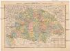
A Magyar szt. korona országainak közigazgatási és közlekedési térképe
1 : 1300000 Maďarsko Homolka, Josef Eggenberger féle könyvkereskedés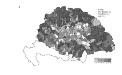
Die Bezirke der Tendenz "A" vor 1875
Ungarn Wahlbezirk, Wahlverhalten
Hungary.
1 : 2500000 Andree, Richard; Times (London, England)
Ungarn.
1 : 2500000 Andree, Richard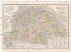
Orts- und Strassenkarte des Königreiches Ungarn
1 : 1296000 Chorvatsko Steinhauser, Anton Artaria
Die kaiserlich oesterreichischen ungarischen Erbstaaten
1 : 1522000 Dalmácie (Chorvatsko) Weiland, Karl Ferdinand im Verlage des Geographischen Instituts
Die kaiserlich oesterreichischen ungarischen Erbstaaten
1 : 1522000 Dalmácie (Chorvatsko) Weiland, Karl Ferdinand im Verlage des Geographischen Instituts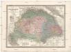
Die kaiserlich oesterreichischen ungarischen Erbstaaten
1 : 1522000 Dalmácie (Chorvatsko) Weiland, Karl Ferdinand im Verlage des Geographischen Instituts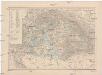
A Magyar szt. korona országai
1 : 2500000 Evropa východní Hölzel Ede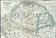
Ungarn 1848, 1849
1 : 7400000 Ungarn Ungarn / Revolution <1848-1849>
Königreich Hungarn
1 : 1321000 Bukovina (Rumunsko a Ukrajina) Mollo, Tranquillo T. Mollo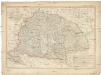
Königreich Hungarn
1 : 1321000 Bukovina (Rumunsko a Ukrajina) Mollo, Tranquillo T. Mollo
Magyar-Ország : General-, Post- und Strassen-Karte des Königreichs Ungarn und des Grossfürstenthums Siebenbürgen / gezeichnet von F. Fried ; gestochen von J. List
1 : 127500 Annotatie: Met administratieve indeling Fried, F.; List, J. Wien : Artaria
Charte von Ungarn, Siebenbürgen u. s. f / nach den bewährtesten Hülfsmitteln neu entworfen und ge
1 : 1600000 1 Karte : Kupferdruck ; 42 x 60 cm Götze, Ferdinand Verlag des Geogr. Instituts
Karte von dem Königreiche Ungarn mit den Königreichen Kroatien und Sklavonien und dem Grossfürstenthum Siebenbürgen
1 : 1390000 Chorvatsko Reilly, Franz Johann Josef von Amon, Anton Franz Joh. Jos. von Reilly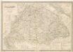
Die Kaiserlich Oesterreichischen Ungarischen Erbstaaten
Die kaiserlich oesterreichischen ungarischen Erbstaaten, das ist Ungarn, Siebenbürgen, Dalmatien und die Militair-Graenze
1 : 1522000 Dalmácie (Chorvatsko) Weiland, Karl Ferdinand im Verlage des Geographischen Instituts


