Maps of Carpathian Mountains
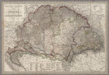
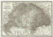
Magyar-Ország : General-, Post- und Strassen-Karte des Königreichs Ungarn und des Grossfürstenthums Siebenbürgen / gezeichnet von F. Fried ; gestochen von J. List
1 : 127500 Annotatie: Met administratieve indeling Fried, F.; List, J. Wien : Artaria
Ungarn 1848, 1849
1 : 7400000 Ungarn Ungarn / Revolution <1848-1849>
Hvngaria Hodierni Temporis In Partes II et Circulos IV divisa
1 : 4300000 Mollova mapová sbírka
Ungarn zur Zeit der Türkenherrschaft
1 : 7400000 Ungarn, Osmanisches Reich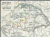
Ungarn's Bisthümer seit den Änderungen unter Maria Theresia
1 : 7400000 Ungarn Maria Theresia, Österreich, Erzherzogin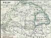
Ungarn nach dem Frieden von Passarowitz 1718
1 : 7400000 Ungarn Požarevac / Friede
Das Königr. Ungarn mit seinen Nebenländern
Maďarsko Benecke Bormann, E. Ignaz Fuchs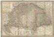
Magyar-Ország
1 : 1400000 Evropa jihovýchodní Fried, Franz List, Joseph Artaria &. Comp.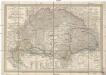
Magyar-Ország
Maďarsko Fried, Franz List, Joseph Artaria &. Comp.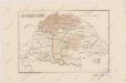
Sbírka map a diagramů použitých na mírových konferencích v Paříži v letech 1919 - 1920

A new map of Hungary, withits divisions into Gespanchafts or Counties,...

Carte particuliere de la Hongrie de la Transilvanie, de la Croatie et de la Sclavonie
1 : 1400000 dressée sur les observations de Mr. le comte Marsilli et sur plusieurs autres memoires par G. Del'isle A Paris : chez l'auteur sur le quai de l'Horloge
Carte particuliere de la Hongrie de la Transilvanie de la Croatie et de la Sclavonie

Szent István koronájához tartozó Orszácoknak térképe
1 : 2100000 Evropa jihovýchodní Thót, Antal Geyertol Földirati intézet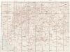
Magyarország és Bosznia automobillal jarható útainak átnézeti térképe
1 : 900000 Bosna Benkö Gyula
Hungary, Transylvania.
1 : 3801600 Lucas, Fielding Jr.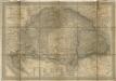
Magyar- Orság
General - Post- und Strassen- Karte des Königreichs Ungarn und des Grossfürstenthums Siebenbürgen
1 : 1400000 Maďarsko Fried, Franz List, Joseph Artaria
Tabula generalis regni Hungariae, Croatiae et Slavoniae nec non magni principatus Tranylvaniae
1 : 1400000 Chorvatsko Lipský, Ján Festetis, Georgio
Tabula generalis regni Hungariae, Croatiae et Slavoniae, nec non magni principatus Transylvaniae
1 : 1400000 Chorvatsko Lipský, Ján Festetis de Tolna, Georgio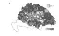
Die Bezirke der Tendenz "A" vor 1875
Ungarn Wahlbezirk, Wahlverhalten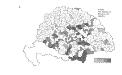
Die Bezirke der Tendenz "C" vor 1875
Ungarn Wahlbezirk, Wahlverhalten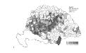
Die Bezirke der Tendenz "C" nach 1875
Ungarn Wahlbezirk, Wahlverhalten
Mappa Mineralographica Fodinas in Hungariâ. Partibusque adhaerentibus Ferè Omnes quae Danubium cominus aut eminus circumstant, et è quibus in eundem substantiae Minerales defluunt, suis distinctas characteribus, ostendens
1 : 1500000 Mollova mapová sbírka Marsili, Luigi Ferdinando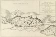
Fodinae Schmelnitzenses
Mollova mapová sbírka Marsili, Luigi Ferdinando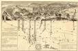
Mappa Metallographica Celebris Fodinae Semnitziensis In Hungariâ Superiori : A Quâ Effoditur Argentum Auro Mixtum, Quae Habenda Est Pro Sectione Montis, In Cuius Visceribus Inspiciuntur Subsequentia
Mollova mapová sbírka Marsili, Luigi Ferdinando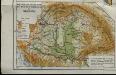
Mountains and plains of the old kingdom of Hungary [Nebenkarte]
Ungarn Topografie Teleki, Pál Teleki, Pál
Regnorum Hungariae, Dalmatiae, Croatiae, Sclavoniae, Bosniae et Serviae cum principatu Transylvaniae, maximaque parte Valachiae nova et exacta tabula
1 : 805000 Chorvatsko Homann, Johann Baptist Müller, Johann Christoph J. B. Homann
Allgemeine Postkarte von Ungarn Kroatien, Sklavonien und Siebenbürgen zur Uebersicht
Chorvatsko Benedict, Anton im von Reillyschen Landkarten und Kunstwerke Verschleiss Komptoir