Maps of Yonne
Dept. De Lyonne.
1 : 563000 Levasseur, Victor.
Département de l'Yonne
1 Karte : Kupferdruck ; 40 x 36 cm Capitaine s.n.
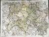
Département de l'Yonne
1 Karte : Kupferdruck ; 49 x 48 cm Houdan au bureau de l'atlas national de France rue Serpente no. 15 et au cabinet bibliographique rue de la vieille Monnoye no. 12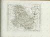


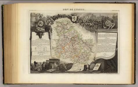
Département de l'Yonne
1 : 260000 Yonne (Francie) Houdan, d'
La generalité de Paris, 4
1 Blatt : 67 x 52 cm chez l'auteur
Troyes 138, uit: Special-Karte von Mittel-Europa / nach amtlichen Quellen bearbeitet von W. Liebenow
1 : 300000 titelvariant: W. Liebenow's Mittel-Europa; Annotatie: Titel boven de bladen: W. Liebenow's Mittel-Europa Johannes Wilhelm Liebenow 1822-1897 Frankfurt a. M. : Ludwig Ravenstein
Le Theatre de Bellone :
Mollova mapová sbírka Schenk, Pieter Braakman, Adriaan
Troyes 138, uit: [W. Liebenow's Special-Karte von Mittel-Europa]
1 : 300000 titelvariant: W. Liebenow's Mittel-Europa; Annotatie: Titel boven de bladen: W. Liebenow's Mittel-Europa Johannes Wilhelm Liebenow 1822-1897 Hannover : Hermann Oppermann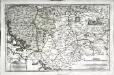
Senones
1 Karte : Kupferdruck ; 35 x 55 cm Sanson; Robert de Vaugondy; Liébaux chés le S. Robert geographe ord. du roi quai de l'Horloge
Lingones
1 Karte : Kupferdruck ; 41 x 47 cm Sanson; Robert de Vaugondy chés le Sr. Robert geog. du r. quai de l'Horloge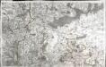
[Auxerre]
1 Blatt : 59 x 91 cm s.n.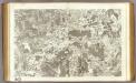
48 Vezelay, Cosne.
1 : 86400 Cassini family; Cassini, Cesar-Francois, 1714-1784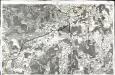
[Vézelay - Cosne]
1 Blatt : 60 x 91 cm Brunet; Aubin s.n.
47 Auxerre.
1 : 86400 Cassini family; Cassini, Cesar-Francois, 1714-1784
46 Sens.
1 : 86400 Cassini family; Cassini, Cesar-Francois, 1714-1784
[Sens]
1 Blatt : 60 x 90 cm s.n.
Morvan.
1 : 186000 Vincent
Govverneme[n]t de Montargis
1 Karte : Kupferdruck ; 11 x 15 cm Sebastian Cramoisy
Gowerneme[n]t de Chau=Regnard
1 Karte : Kupferdruck ; 11 x 15 cm Sebastian Cramoisy
Plan de la ville, favxbovrgs et dependances de Troyes capitale de Champagne
1 : 9100 Troyes (Francie) Desbois, Maria
Chav Regnard
1 Plan : Kupferdruck ; 11 x 15 cm Sebastian Cramoisy
Montargis
1 Plan : Kupferdruck ; 11 x 15 cm Sebastian Cramoisy
Gouvernement Generalite De Paris, Divisée En Esslections [Karte], in: Atlas nouveau, contenant toutes les parties du monde [...], Bd. 1, S. 86.
1 Karte aus Atlas Sanson, Nicolas Jaillot, Alexis Hubert und Mortier, Pieter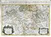
Gouvernement et generalité de Paris, seconde partie
1 Karte : H. Jaillot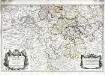
La generalité de Paris, 2
1 Karte : Dezauche
Composite 9: Carte de France.
1 : 86400 Cassini family; Cassini, Cesar-Francois, 1714-1784
Le Berri et le Nivernois, la Beauce et la Sologne
1 Karte : Kupferdruck ; 47 x 52 cm Fer; Starckman; Bénard chez Benard dans l'isle du Palais sur le quay de l'Orloge a la sphere royale