Maps of Auxerre
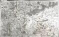
[Auxerre]
1 Blatt : 59 x 91 cm s.n.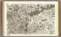
47 Auxerre.
1 : 86400 Cassini family; Cassini, Cesar-Francois, 1714-1784
Govverneme[n]t de Montargis
1 Karte : Kupferdruck ; 11 x 15 cm Sebastian Cramoisy
Gowerneme[n]t de Chau=Regnard
1 Karte : Kupferdruck ; 11 x 15 cm Sebastian Cramoisy
Chav Regnard
1 Plan : Kupferdruck ; 11 x 15 cm Sebastian Cramoisy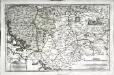
Senones
1 Karte : Kupferdruck ; 35 x 55 cm Sanson; Robert de Vaugondy; Liébaux chés le S. Robert geographe ord. du roi quai de l'Horloge
Le Theatre de Bellone :
Mollova mapová sbírka Schenk, Pieter Braakman, Adriaan
Département de l'Yonne
1 : 260000 Yonne (Francie) Houdan, d'

Département de l'Yonne
1 Karte : Kupferdruck ; 49 x 48 cm Houdan au bureau de l'atlas national de France rue Serpente no. 15 et au cabinet bibliographique rue de la vieille Monnoye no. 12
Troyes 138, uit: [W. Liebenow's Special-Karte von Mittel-Europa]
1 : 300000 titelvariant: W. Liebenow's Mittel-Europa; Annotatie: Titel boven de bladen: W. Liebenow's Mittel-Europa Johannes Wilhelm Liebenow 1822-1897 Hannover : Hermann Oppermann
Département de l'Yonne
1 Karte : Kupferdruck ; 40 x 36 cm Capitaine s.n.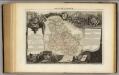
Dept. De Lyonne.
1 : 563000 Levasseur, Victor.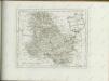

GASTINOIS | ET | SENONOIS
Amsterdami | Excud. Guiljemus | Blaeu
16) V.S.E. ''Orléans'', uit: Carte géologique de France
1 : 500000 Annotatie: Voor aanwezige bladen zie bladoverzicht [S.l : s.n.]
Carte du gouvernement de Champagne, 3
2 Blätter : 38 x 95 cm Bourgoin
Karte vom Kriegestheater der vereinigten preussischen und östreichischen Armeen in Frankreich in VI. Blättern, [Blatt 7 und 10]
2 Teile auf 2 Blättern : 48 x 38 cm Königl. preuss. Akademische Kunst- und Buchhandlung

Partie méridionale du gouvernem.t général de Champagne
1 Karte : Kupferdruck ; 47 x 63 cm Robert de Vaugondy; Haussard s.n.
Carte des dérivations d'eaux de sources
1 : 320000 [s.n.]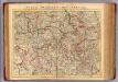
Champagne Meridionale.
1 : 336000 L'Isle, Guillaume de, 1675-1726
Gastinois Et Senonois. [Karte], in: Novus Atlas, das ist, Weltbeschreibung, Bd. 2, S. 54.
1 Karte aus Atlas Blaeu, Joan Blaeu, Willem Janszoon
Gastinois Et Senonois. [Karte], in: Theatrum orbis terrarum, sive, Atlas novus, Bd. 2, S. 62.
1 Karte aus Atlas Blaeu, Joan Blaeu, Willem Janszoon
Gastinois et Senonois [Karte], in: Novus atlas absolutissimus, Bd. 4, S. 103.
1 Karte aus Atlas Janssonius Offizin
Gastinois Et Senonois [Karte], in: Gerardi Mercatoris et I. Hondii Newer Atlas, oder, Grosses Weltbuch, Bd. 2, S. 62.
1 Karte aus Atlas Mercator, Gerhard und Hondius, Jodocus Jansson, Jan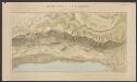
Gastinois Et Senonois. [Karte], in: Le théâtre du monde, ou, Nouvel atlas contenant les chartes et descriptions de tous les païs de la terre, Bd. 2, S. 54.
1 Karte aus Atlas Blaeu, Willem Janszoon und Blaeu, Joan Blaeu, Willem Janszoon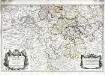
La generalité de Paris, 2
1 Karte : Dezauche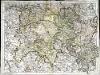
Partie meridionale de Champagne
1 Karte : Kupferdruck ; 45 x 61 cm L'Isle chez l'auteur sur le quai de l'Horloge
![[Auxerre]](http://biblio.unibe.ch/web-apps/maps/zoomify.php?pic=Ryh_2302_33.jpg&col=ryh)

