Maps of New York City

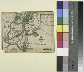
A draught of New York and Perthamboy Harbour.
from Charts and maps
Map of the counties of New York, Queens, Kings, and Richmond.
from An atlas of the state of New York, designed for the use of engineers, containing a map of the state and of the several counties. / Projected and drawn ... under the superintendence and direction of Simeon de Witt.
Vingboons map of Manhattan, 1639 : a facsimile from the Library of Congress.
from Whole
Map of the counties of New York, Queens, Kings, and Richmond.
from An atlas of the state of New York : containing a map of the state and of the several counties / by David H. Burr.
Map of New-York Bay and Harbor and the environs / founded upon a trigonometrical survey under the direction of F.R. Hassler, superintendent of the Survey of the Coast of the United States ; triangulation by James Ferguson and Edmund Blunt, assistants ; t
from New York harbor
Map of New-York Bay and Harbor and the environs : [with colored manuscript additions to show positions of troops and fleets at the Battle of Long Island, 1776] / founded upon a trigonometrical survey under the direction of F.R. Hassler, superintendent of
from New York harbor
Map ... Around The City Of New York.
1 : 205920 Colton, J. H.
Map Of The Country Thirty Miles Round the City of New York.
1 : 190080 Eddy, John H.
New York and vicinity [map]
1 : 24000 Geological Survey (U.S.) Geological Survey
Hammond's complete map of Brooklyn.
From Brooklyn
Map of the Country Twenty Five Miles Round The City Of New-York.
1 : 300000 Greenleaf, Jeremiah
Map of the Country Twenty Five Miles Round The City Of New-York.
1 : 316800 Greenleaf, Jeremiah
United States--east coast, New York--New Jersey, New York Harbor / Coast Survey.
from New York harbor
Watson's guide map to summer resorts around New York.
from Whole
Nature's estuary: the historic tidelands of the New York New Jersey harbor estuary / cartographic design by Jennifer Cox; cartographers George Colbert and Guenter Vollath.
Jennifer Cox; George Colbert; Guenter Vollath,
Map of New-York and its vicinity /drawn by D.H. Burr, geographer ; engraved by S. Stiles, Sherman & Smith.
from New York harbor
Map of New York City, (Greater New York).
From Manhattan
Map of the Country Twenty Five Miles Round The City Of New-York.
1 : 211200 Burr, David H., 1803-1875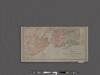
Map of New York City showing portions of Brooklyn, Jersey City, and Westchester Co.
From Manhattan
Mass Transit program New York City
From The Borough
Sanitation
From Environment
Mass Transit program New York City
From The Borough
Index to Sectional aerial maps of the City of New York / [photographed and assembled under the direction of the chief engineer, July 1st, 1924].
from Sectional aerial maps of the City of New York / [photographed and assembled under the direction of the chief engineer, July 1st, 1924].
A plan of the city of New-York & its environs : to Greenwich, on the North or Hudsons River, and to Crown Point, on the East or Sound River, shewing the several streets, publick buildings, docks, fort & battery, with the true form & course of the command
from Charts and maps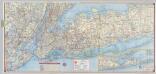
Shell Metropolitan New York and Long Island. Eastern Long Island.
1 : 126720 Shell Oil Company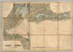
New York Bay And Harbor.
1 : 79200 United States Coast Survey
New York Bay and Harbor, New York.
1 : 126720 United States Coast Survey
Chart and plan of the harbour of New York & the couny. adjacent, from Sandy Hook to Kingsbridge : comprehending the whole of New York and Staten Islands, and part of Long Island & the Jersey shore, and shewing the defences of New York both by land and se
from Cartographic materials from the Emmet Collection of Manuscripts Etc. Relating to American History.
Coast Chart No. 20 New York Bay And Harbor, New York.
1 : 80000 United States Coast Survey