Maps of Teaneck Township

Bergen County, V. 1, Double Page Plate No. 13 [Map bounded by Hackensack River, North St., Queen Anne Rd., Hackensack Ave.] / by George W. and Walter S. Bromley.
From V. 1, 1912.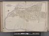
Bergen County, V. 1, Double Page Plate No. 12 [Map bounded by Hackensack River, Hackensack Ave., Township of Teaneck, Overpeck Creek] / by George W. and Walter S. Bromley.
From V. 1, 1912.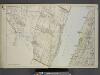
Portion of Bergen County, N.J.
from Atlas of the Hudson River Valley from New York city to Troy, including a section of about 8 miles in width. Published by Watson & co. Compiled from official records and careful surveys, under the supervision of F. W. Beers.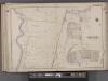
Bergen County, V. 1, Double Page Plate No. 15 [Map bounded by Washington Ave., Tryon Ave., Cedar Lane, Hackensack River] / by George W. and Walter S. Bromley.
From V. 1, 1912.
1. New York City.
1 : 80000 Servoss, R. D.
N.Y. City, Brooklyn.
1 : 41500 Bien, Joseph Rudolf
New York City.
1 : 41000 Rand McNally and Company
New York City, County.
1 : 31680 Vermeule, C. C. (Cornelius Clarkson), 1858-1950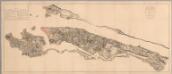
Composite: Steven's facsimile of British head quarters manuscript map of New York
1 : 9800 Stevens, Benjamin Franklin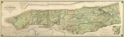
Composite: Topographical Atlas Of The City Of New York
1 : 12000 Viele, Egbert L.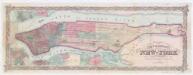
Colton's city & county map of New-York
1 : 20000 G.W. & C.B. Colton & Co G.W. and C.B. Colton
TheHeart of New York: Grand Central Terminal: Only Railway Station on the Subway, Elevated, and Surface Lines.
From Manhattan
Heart of New York.
1 : 29800 New York Central Railroad Company
Map of New York City showing portions of Brooklyn, Jersey City, and Westchester Co.
from Whole
Map of the borough of Manhattan and part of the Bronx showing location and extent of racial colonies.
From Manhattan
New York and vicinity.
1 : 42240 Morse, Sidney E. (Sidney Edwards), 1794-1871
Paterson
1 : 62500
Paterson
1 : 62500
Paterson
1 : 62500
Paterson
1 : 62500
Paterson
1 : 62500
Paterson
1 : 62500
Paterson
1 : 62500
Paterson
1 : 62500
Paterson
1 : 62500
Paterson
1 : 62500
Paterson
1 : 62500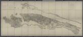
Facsimile of the unpublished British head quarters coloured manuscript map of New York & environs / reproduced from the original drawing in the War Office, London.
from Whole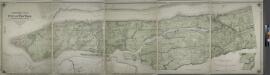
Topographical atlas of the city of New York, including the annexed territory showing original water courses and made land.
from Topographical atlas of the city of New York, / including the annexed territory showing original water courses and made land / prepared under the direction of Egbert L. Viele.
![Bergen County, V. 1, Double Page Plate No. 13 [Map bounded by Hackensack River, North St., Queen Anne Rd., Hackensack Ave.] / by George W. and Walter S. Bromley.](https://images-0.georeferencer.com/images/iiif/847990975343/full/,300/0/native.jpg)

