Maps of North Bergen

Maps of North Bergen

$title$

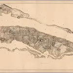
Composite: Steven's facsimile of British head quarters manuscript map of New York

1 : 9800 Stevens, Benjamin Franklin
$title$

Facsimile of the unpublished British head quarters coloured manuscript map of New York & environs / reproduced from the original drawing in the War Office, London.

from Whole
$title$

New York and vicinity.

1 : 42240 Morse, Sidney E. (Sidney Edwards), 1794-1871
$title$

Topographical map of the city and county of New-York and the adjacent country : with views in the border of the principal buildings and interesting scenery of the island

1 : 16000 S. Stiles & Co Sherman & Smith
$title$

Map of the city and county of New York : with the adjacent country / by David H. Burr.

from An atlas of the state of New York : containing a map of the state and of the several counties. / Projected and drawn under the superintendence and direction of Simeon de Witt ... And also the physical geography of the State ...
$title$

Map of the city and county of New York : with the adjacent country / by David H. Burr.

from An atlas of the state of New York, designed for the use of engineers, containing a map of the state and of the several counties. / Projected and drawn ... under the superintendence and direction of Simeon de Witt.
$title$

Map of the city and county of New York : with the adjacent country / by David H. Burr.

from Whole
$title$

TheHeart of New York: Grand Central Terminal: Only Railway Station on the Subway, Elevated, and Surface Lines.

From Manhattan
$title$

City & county map of New-York, Brooklyn, Williamsburgh, Jersey City & the adjacent waters / by J.H. Colton, N.Y. ; engraved by D.G. Johnson, N. York.

from Manhattan
$title$

Colton's city & county map of New-York

1 : 20000 G.W. & C.B. Colton & Co G.W. and C.B. Colton
$title$

Map of the city and county of New York : with the adjacent country / by David H. Burr.

from An atlas of the state of New York : containing a map of the state and of the several counties / by David H. Burr.
$title$

Composite: Topographical Atlas Of The City Of New York

1 : 12000 Viele, Egbert L.
$title$

[General map of the city of New York, Boroughs of Manhattan, Brooklyn, Bronx, Queens, and Richmond ; designed and prepared by Louis A. Risse. New York : Board of Public Improvements. Topographical Bureau.] Photos of part of map only (Manhattan)

From Manhattan
$title$

Map of the borough of Manhattan and part of the Bronx showing location and extent of racial colonies.

From Manhattan
$title$

Map of the Borough of Manhattan, New York City, centering on the campus of Columbia University.

From Manhattan
$title$

Heart of New York.

1 : 29800 New York Central Railroad Company
$title$

Goulding's Directory Map of New York City, including the two recently annexed wards, engraved from the latest and most accurate surveys.

From Manhattan
$title$

New York City

from New topographical atlas and gazetteer of New York, comprising a topographical view of the several counties of the state, ... including ... map of the United States and territories ... Compiled from the latest astronomical observations, official surveys and records of the United States and territories ...
$title$

New York city map.

From Manhattan
$title$

Aerial survey, Manhattan Island,New York City.

From Manhattan
$title$

Topographical map of New York City, County and vicinity, showing old farm lines, etc. Based on Radell's and other official surveys, drawings and modern surveys.

From Manhattan
$title$

City and County Of New - York.

1 : 15840 Colton, J. H.
$title$

New York City Map. Extracted from Phelps' strangers and citizens' guide to New York City, with maps and engravings.

From Manhattan
$title$

Watson's New Map Of New-York And Adjacent Cities.

1 : 18600 Watson, Gaylord
$title$

New York City map. Including an index to the streets of New York and Brooklyn.

From Manhattan
$title$

Plate 6: Plan of New York and Brooklyn.

from Atlas of New York and vicinity : from actual surveys / by and under the direction of F. W. Beers, assisted by A. B. Prindle & others
$title$

New York city map

Miller, James J. Miller
$title$

Topographical map of New York City, County and vicinity : showing old farm lines &c. / based on Randells and other official surveys, drawings and modern surveys by J.F. Harrison & T. Magrane ; printed by C. Wadlow.

from (A-Z)
$title$

Topographical atlas of the city of New York, including the annexed territory showing original water courses and made land.

from Topographical atlas of the city of New York, / including the annexed territory showing original water courses and made land / prepared under the direction of Egbert L. Viele.
$title$

New York City

from Manhattan
© MapTiler © OpenStreetMap contributors
How does it work?
These instructions will show you how to find historical maps online.
Getting started
Type the place name in the search box to find the exact location. You can further adjust the search by zooming in and out.
Zoom
Zoom in and out with the buttons or use your mouse or touchpad natively.
Exact Area tool
Click here and draw a rectangle over the map to precisely define the search area.
Set filters
Narrow your search with advanced settings, such as Years (from/to), Fulltext, Publisher, etc.
Results
See the results of your search on the right side. You can scroll down to find more maps of this location.
?

Download OldMapsOnline Mobile