Maps of Queens County

Manhattan, V. 7, Plate No. 7 [Map bounded by W. 81st St., Columbus Ave., W. 76th St., Amsterdam Ave.]
From Atlas 120. Vol. 7, 1902.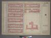
Plate 8, Part of Section 4: [Bounded by W. 83rd Street, Central Park West, W. 77th Street and Amsterdam Avenue.]
from Atlas of the city of New York, borough of Manhattan. From actual surveys and official plans / by George W. and Walter S. Bromley.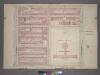
Plate 8, Part of Section 4: [Bounded by W. 83rd Street, Central Park West, W. 77th Street and Amsterdam Avenue.]
from Atlas of the city of New York, borough of Manhattan. From actual surveys and official plans / by George W. and Walter S. Bromley.
Part of Section 4 : Plate 93.
from Atlas of the borough of Manhattan, city of New York.
Manhattan, V. 7, Plate No. 6 [Map bounded by W. 81st St., Amsterdam Ave., W. 76th St., W. End Ave.]
From Atlas 120. Vol. 7, 1902.
Manhattan, V. 7, Plate No. 8 [Map bounded by W. 81st St., Central Park West, W. 76th St., Columbus Ave.]
From Atlas 120. Vol. 7, 1902.
Manhattan V. 7, Plate No. 8 [Map bounded by Columbus Ave., Manhattan Sq., Central Park West, W. 75th St.]
From Atlas 121. Vol. 7, pt. 1, 1912.
Manhattan, V. 7, Plate No. 3 [Map bounded by Amsterdam Ave., W. 76th St., Columbus Ave., W. 72nd St.]
From Atlas 120. Vol. 7, 1902.
Manhattan, V. 7, Plate No. 11 [Map bounded by W. 86th St., Columbus Ave., W. 81st St., Amsterdam Ave.]
From Atlas 120. Vol. 7, 1902.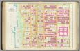
Pl. 26: ward 22.
1 : 1800 Bromley, George Washington; Bromley, Walter Scott
[Plate 25: Bounded by W. 75th Street, Central Park West (8th Avenue), W. 64th Street and (Hudson River) Twelfth Avenue.]
from Atlas of the city of New York, Manhattan Island. From actual surveys and official plans / by George W. and Walter S. Bromley.
Part of Section 4 : New York City.
from Atlas of the city of New York, borough of Manhattan. From actual surveys and official plans / by George W. and Walter S. Bromley.
[Plate 26: Bounded by W. 86th Street, Central Park West (8th Avenue), W. 75th Street and Hudson River.]
from Atlas of the city of New York, Manhattan Island. From actual surveys and official plans / by George W. and Walter S. Bromley.
[Plate 25: Bounded by W. 75th Street, Central Park West (8th Avenue), W. 64th Street, [Hudson River Piers E-I], W. 72nd Street, and Riverside Avenue.]
from Atlas of the city of New York, borough of Manhattan. From actual surveys and official plans / by George W. and Walter S. Bromley.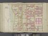
Manhattan, Double Page Plate No. 26 [Map bounded by W. 86th St., Central Park W., W. 75th St., Hudson River]
From Atlas of the city of New York, Manhattan Island. From actual surveys and official plans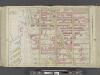
Manhattan, Double Page Plate No. 25 [Map bounded by W. 75th St., Central Park W., W. 64th St., Hudson River]
From Atlas of the city of New York, Manhattan Island. From actual surveys and official plans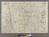
Part of Ward 22, New York City.
from Atlas of the city of New York : embracing all territory within its corporate limits from official records, private plans & actual surveys / by and under the supervision of E. Robinson & R.H. Pidgeon, civil engineers.
Part of Wards 12 & 22, New York City.
from Atlas of the city of New York : embracing all territory within its corporate limits from official records, private plans & actual surveys / by and under the supervision of E. Robinson & R.H. Pidgeon, civil engineers.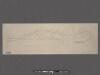
Riverside Park [New York City.]
From Manhattan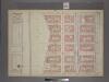
Plate 7, Part of Section 4: [Bounded by W. 83rd Street, Amsterdam Avenue, W. 77th Street and (Riverside Park) Riverside Drive.]
from Atlas of the city of New York, borough of Manhattan. From actual surveys and official plans / by George W. and Walter S. Bromley.
[Plate 92: Bounded by W. 83rd Street, Amsterdam Avenue, W. 77th Street, and [Hudson River, Riverside Park] Riverside Drive.]
from Atlas of the borough of Manhattan, city of New York.
[Plate 91: Bounded by W. 77th Street, Central Park West, W. 71st Street, Broadway, and Amsterdam Avenue.]
from Atlas of the borough of Manhattan, city of New York.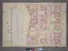
Plate 7, Part of Section 4: [Bounded by W. 83rd Street, Amsterdam Avenue, W. 77th Street, West End Avenue and Riverside Drive.]
from Atlas of the city of New York, borough of Manhattan. From actual surveys and official plans / by George W. and Walter S. Bromley.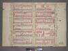
Plate 5, Part of Section 4: [Bounded by W. 77th Street, Central Park West, W. 71st Street and Amsterdam Avenue.]
from Atlas of the city of New York, borough of Manhattan. From actual surveys and official plans / by George W. and Walter S. Bromley.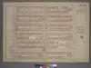
Plate 5, Part of Section 4: [Bounded by W. 77th Street, Central Park West, W. 71st Street and Amsterdam Avenue.]
from Atlas of the city of New York, borough of Manhattan. From actual surveys and official plans / by George W. and Walter S. Bromley.
Manhattan, V. 7, Plate No. 64 [Map bounded by Central Park West, 5th Ave.]
From Atlas 120. Vol. 7, 1902.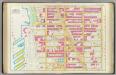
Pl. 25: ward 22.
1 : 1800 Bromley, George Washington; Bromley, Walter Scott
Part of Section 4 : Plate 95.
from Atlas of the borough of Manhattan, city of New York.
Part of Section 4 : Plate 90.
from Atlas of the borough of Manhattan, city of New York.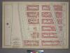
![Manhattan, V. 7, Plate No. 7 [Map bounded by W. 81st St., Columbus Ave., W. 76th St., Amsterdam Ave.]](https://images-2.georeferencer.com/images/iiif/945299102972/full/,300/0/native.jpg)

