Maps of Queens County
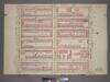
Plate 5, Part of Section 4: [Bounded by W. 77th Street, Central Park West, W. 71st Street and Amsterdam Avenue.]
from Atlas of the city of New York, borough of Manhattan. From actual surveys and official plans / by George W. and Walter S. Bromley.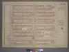
Plate 5, Part of Section 4: [Bounded by W. 77th Street, Central Park West, W. 71st Street and Amsterdam Avenue.]
from Atlas of the city of New York, borough of Manhattan. From actual surveys and official plans / by George W. and Walter S. Bromley.
[Plate 91: Bounded by W. 77th Street, Central Park West, W. 71st Street, Broadway, and Amsterdam Avenue.]
from Atlas of the borough of Manhattan, city of New York.
Manhattan, V. 7, Plate No. 3 [Map bounded by Amsterdam Ave., W. 76th St., Columbus Ave., W. 72nd St.]
From Atlas 120. Vol. 7, 1902.
Manhattan, V. 7, Plate No. 4 [Map bounded by W. 76th St., Central Park West, W. 72nd St., Columbus Ave.]
From Atlas 120. Vol. 7, 1902.
Manhattan V. 7, Plate No. 8 [Map bounded by Columbus Ave., Manhattan Sq., Central Park West, W. 75th St.]
From Atlas 121. Vol. 7, pt. 1, 1912.
Manhattan, V. 6, Double Page Plate No. 117 [Map bounded by W. 72nd St., Central Park West, W. 67th St., Amsterdam Ave.]
From Atlas 117. Vol. 6, 1892.
Plate 117: Map bounded by West 72nd Street, Eighth Avenue, West 67th Street, Tenth Avenue
from Maps of the city of New York.
Manhattan, V. 7, Plate No. 2 [Map bounded by W. 76th St., Amsterdam Ave., W. 72nd St., W. End Ave.]
From Atlas 120. Vol. 7, 1902.
Manhattan, V. 7, Plate No. 8 [Map bounded by W. 81st St., Central Park West, W. 76th St., Columbus Ave.]
From Atlas 120. Vol. 7, 1902.
Manhattan, V. 7, Plate No. 7 [Map bounded by W. 81st St., Columbus Ave., W. 76th St., Amsterdam Ave.]
From Atlas 120. Vol. 7, 1902.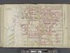
Manhattan, Double Page Plate No. 25 [Map bounded by W. 75th St., Central Park W., W. 64th St., Hudson River]
From Atlas of the city of New York, Manhattan Island. From actual surveys and official plans
[Plate 25: Bounded by W. 75th Street, Central Park West (8th Avenue), W. 64th Street, [Hudson River Piers E-I], W. 72nd Street, and Riverside Avenue.]
from Atlas of the city of New York, borough of Manhattan. From actual surveys and official plans / by George W. and Walter S. Bromley.
[Plate 25: Bounded by W. 75th Street, Central Park West (8th Avenue), W. 64th Street and (Hudson River) Twelfth Avenue.]
from Atlas of the city of New York, Manhattan Island. From actual surveys and official plans / by George W. and Walter S. Bromley.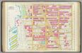
Pl. 25: ward 22.
1 : 1800 Bromley, George Washington; Bromley, Walter Scott
Part of Section 4 : Plate 93.
from Atlas of the borough of Manhattan, city of New York.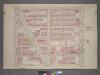
Plate 4, Part of Section 4: [Bounded by W. 77th Street, Central Park West, W. 65th Street and Amsterdam Avenue.]
from Atlas of the city of New York, borough of Manhattan. From actual surveys and official plans / by George W. and Walter S. Bromley.
Part of Section 4 : Plate 89.
from Atlas of the borough of Manhattan, city of New York.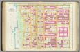
Pl. 26: ward 22.
1 : 1800 Bromley, George Washington; Bromley, Walter Scott
Plate 8, Part of Section 4: [Bounded by W. 83rd Street, Central Park West, W. 77th Street and Amsterdam Avenue.]
from Atlas of the city of New York, borough of Manhattan. From actual surveys and official plans / by George W. and Walter S. Bromley.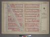
Plate 4, Part of Section 4: [Bounded by W. 71st Street, Central Park West, W. 65th Street and Amsterdam Avenue.]
from Atlas of the city of New York, borough of Manhattan. From actual surveys and official plans / by George W. and Walter S. Bromley.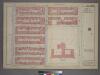
Plate 8, Part of Section 4: [Bounded by W. 83rd Street, Central Park West, W. 77th Street and Amsterdam Avenue.]
from Atlas of the city of New York, borough of Manhattan. From actual surveys and official plans / by George W. and Walter S. Bromley.
M-T-10-119: [Bounded by West 74th Street, West 75th Street, West 76th Street, West Drive, and The Lake.]
from Topographical survey of portion of Central Park, Boro. of Manhattan ... / City of New York, Department of Parks, Topographical Division.
Part of Section 4 : Plate 90.
from Atlas of the borough of Manhattan, city of New York.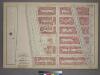
Plate 6, Part of Section 4: [Bounded by W. 77th Street, Amsterdam Avenue, W. 71st Street and (Riverside Park) Riverside Drive.]
from Atlas of the city of New York, borough of Manhattan. From actual surveys and official plans / by George W. and Walter S. Bromley.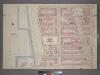
Plate 6, Part of Section 4: [Bounded by W. 77th Street, Amsterdam Avenue, W. 71st Street, West End Avenue, W. 72nd Street and Riverside Drive.]
from Atlas of the city of New York, borough of Manhattan. From actual surveys and official plans / by George W. and Walter S. Bromley.
M-T-10-121: [Bounded by West 70th Street, West 71st Street, West 72nd Street, West 73rd Street and the Lake.]
from Topographical survey of portion of Central Park, Boro. of Manhattan ... / City of New York, Department of Parks, Topographical Division.
M-T-10-117: [Bounded by Central Park West, Transverse Road No. 2 and West Drive.]
from Topographical survey of portion of Central Park, Boro. of Manhattan ... / City of New York, Department of Parks, Topographical Division.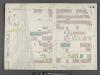
Manhattan, V. 6, Double Page Plate No. 115 [Map bounded by W. 72nd St., Amsterdam Ave., W. 67th St., 12th Ave.]
From Atlas 117. Vol. 6, 1892.
![Plate 5, Part of Section 4: [Bounded by W. 77th Street, Central Park West, W. 71st Street and Amsterdam Avenue.]](https://images-2.georeferencer.com/images/iiif/429619187056/full/,300/0/native.jpg)

