Maps of Richmond County

Staten Island, V. 2, Plate No. 147 [Map bounded by Dongan Ave., Little Clove Rd., Chestnut Ave., Todt Hill Rd., Fairview Ave.]
From Atlas 163.1. Vol. 2, 1917.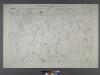
Sheet No. 39.[Includes Ocean Terrace, Manor Road, Egbert Avenue, Walkers lane Todt Hill Road in Todt Hill and Dongan Hills.]; Borough of Richmond, Topographical Survey.
from Borough of Richmond, Topographical Survey. Staten Island. Topographical Bureau.,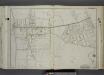
Part of Wards 1 & 2. [Map bound by Dongan Ave, Fairview Ave, Knox PL (1st St), Slosson Ave, Richmond Turnpike, Clove Road, Schoharie St, Cayuga St, Oswego St, Saratoga Ave, Little Clove Road, Ocean Terrace, Chestnut Ave, Todt Hill Ro
from Atlas of the city of New York, borough of Richmond, Staten Island. From actual surveys and original plans, by George W. and Walter S. Bromley.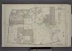
Part of Ward 1. [Map bound by Cherry Lane, Forest Ave, Lowell Ave, Davis Ave, Pelton Ave, Bard Ave, Glove Road, Richmond Turnpike, Jewett Ave]
from Atlas of the borough of Richmond, city of New York.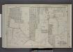
Part of Wards 2 & 3. [Map bound by Richmond Turnpike, Chestnut Ave, Todt Hill Road, Ocean Terrace, Manor Road, Egbert Ave, New Road, Willow Brook Road, Woodward Ave]
from Atlas of the borough of Richmond, city of New York.
Section 12
from Atlas of Staten Island, Richmond County, New York, from official records and surveys; compiled and drawn by F. W. Beers.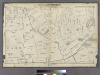
Section 7.
from Atlas of Staten Island, Richmond County, New York, from official records and surveys; compiled and drawn by F. W. Beers.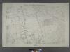
Borough of Richmond, Topographical Survey.
from Borough of Richmond, Topographical Survey.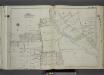
Part of Ward 1. [Map bound by Egbert Ave, Brookside Ave, Forest Ave, Clove Road, Purcell St, Raleigh Ave (Division Ave), Broadway, 1st St, Bement Ave, Britton Ave, Slosson Ave, Fairview Ave, Potter Ave, Manor Road, Marlboro PL, Palmer Ave, Wina
from Atlas of the city of New York, borough of Richmond, Staten Island. From actual surveys and original plans, by George W. and Walter S. Bromley.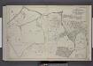
Part of Wards 2 & 4. [Map bound by Richmond Turnpike, Clove Oak St, Richmond Road, Clove Ave, The Staten Island Railway Co., Old Town Road, Ocean Terrace, Todt Hill Road, Chestnut Ave]
from Atlas of the borough of Richmond, city of New York.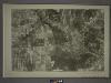
21C - N.Y. City (Aerial Set).
from Sectional aerial maps of the City of New York / [photographed and assembled under the direction of the chief engineer, July 1st, 1924].
Height District Map Section No. 21; Height district map / City of New York, Board of Estimate and Apportionment.
from Height district map / City of New York, Board of Estimate and Apportionment. New York (N.Y.). Board of Estimate and Apportionment,
Area District Map Section No. 21; Area district map / City of New York, Board of Estimate and Apportionment.
from Area district map / City of New York, Board of Estimate and Apportionment. New York (N.Y.). Board of Estimate and Apportionment,
Use District Map Section No. 21; Use district map / City of New York, Board of Estimate and Apportionment.
from Use district map / City of New York, Board of Estimate and Apportionment. New York (N.Y.). Board of Estimate and Apportionment,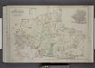
Part of Wards 2, 3, & 4. [Map bound by Forest Hill Road, New Road, Willow Brook Road, Manor Road, Ocean Terrace, Richmond Road, Amboy Road, Fresh Kills Road, Richmond Hill Road; Sub Plan - Summit Ave, Beacon Ave, Grand Ave, Walden PL, Pleasant
from Atlas of the borough of Richmond, city of New York.
General map of the borough of Richmond (Staten Island) in the city of New York : showing in addition to the existing topographical features of the borough a tentative and preliminary plan for a street system of the same.
from Staten Island
Brighton Heights, Clifton, Fort Wadsworth, Fox Hills, Grymes hill, Livingston, New Brighton, Randall Manor, Rosebank, Shore Acres, St. George, Stapleton, Tompkinsville, Ward hill, West New Brighton. (cont.)
From District 2
Map of the Village of New Brighton, Richmond Co., New York City, NY.
From Staten Island
The Narrows
1 : 24000
The Narrows
1 : 24000
The Narrows
1 : 24000
The Narrows
1 : 24000
The Narrows
1 : 24000
The Narrows
1 : 24000
The Narrows
1 : 24000
The Narrows
1 : 24000
The Narrows
1 : 24000
Map of Staten Island o Richmond County. 16 views of buildings on border. Also view of Elliottville the property of Dr. S. M. Elliott.
From Staten Island
Staten Island South.
1 : 253440 Dripps, Matthew
![Staten Island, V. 2, Plate No. 147 [Map bounded by Dongan Ave., Little Clove Rd., Chestnut Ave., Todt Hill Rd., Fairview Ave.]](https://images-2.georeferencer.com/images/iiif/267722609284/full/,300/0/native.jpg)

